
The Cray-1 was a supercomputer designed, manufactured and marketed by Cray Research. Announced in 1975, the first Cray-1 system was installed at Los Alamos National Laboratory in 1976. Eventually, eighty Cray-1s were sold, making it one of the most successful supercomputers in history. It is perhaps best known for its unique shape, a relatively small C-shaped cabinet with a ring of benches around the outside covering the power supplies and the cooling system.
The Community Climate System Model (CCSM) is a coupled general circulation model (GCM) developed by the University Corporation for Atmospheric Research (UCAR) with funding from the National Science Foundation (NSF), the Department of Energy (DoE), and the National Aeronautics and Space Administration (NASA). The coupled components include an atmospheric model, a land-surface model, an ocean model, and a sea ice model. CCSM is maintained by the National Center for Atmospheric Research (NCAR).

A dropsonde is an expendable weather reconnaissance device created by the National Center for Atmospheric Research (NCAR), designed to be dropped from an aircraft at altitude over water to measure storm conditions as the device falls to the surface. The sonde contains a GPS receiver, along with pressure, temperature, and humidity (PTH) sensors to capture atmospheric profiles and thermodynamic data. It typically relays this data to a computer in the aircraft by radio transmission.
The MM5 is a regional mesoscale model used for creating weather forecasts and climate projections. It is a community model maintained by Penn State University and the National Center for Atmospheric Research. The MM5 is a limited-area, terrain-following sigma coordinate model that is used to replicate or forecast mesoscale and regional scale atmospheric circulation. It has been updated many times since the 1970s to fix bugs, adapt to new technologies, and work on different types of computers and software. It is used in many different ways: for research and for weather prediction. In research, it is used to compare it to other models, to see what works and what does not work. It is also used for air quality models.
OPeNDAP is an acronym for "Open-source Project for a Network Data Access Protocol," an endeavor focused on enhancing the retrieval of remote, structured data through a Web-based architecture and a discipline-neutral Data Access Protocol (DAP). Widely used, especially in Earth science, the protocol is layered on HTTP, and its current specification is DAP4, though the previous DAP2 version remains broadly used. Developed and advanced by the non-profit OPeNDAP, Inc., DAP is intended to enable remote, selective data-retrieval as an easily invoked Web service. OPeNDAP, Inc. also develops and maintains zero-cost (reference) implementations of the DAP protocol in both server-side and client-side software.
The Earth System Modeling Framework (ESMF) is open-source software for building climate, numerical weather prediction, data assimilation, and other Earth science software applications. These applications are computationally demanding and usually run on supercomputers. The ESMF is considered a technical layer, integrated into a sophisticated common modeling infrastructure for interoperability. Other aspects of interoperability and shared infrastructure include: common experimental protocols, common analytic methods, common documentation standards for data and data provenance, shared workflow, and shared model components.

The US National Center for Atmospheric Research is a US federally funded research and development center (FFRDC) managed by the nonprofit University Corporation for Atmospheric Research (UCAR) and funded by the National Science Foundation (NSF). NCAR has multiple facilities, including the I. M. Pei-designed Mesa Laboratory headquarters in Boulder, Colorado. Studies include meteorology, climate science, atmospheric chemistry, solar-terrestrial interactions, environmental and societal impacts.

In atmospheric science, an atmospheric model is a mathematical model constructed around the full set of primitive, dynamical equations which govern atmospheric motions. It can supplement these equations with parameterizations for turbulent diffusion, radiation, moist processes, heat exchange, soil, vegetation, surface water, the kinematic effects of terrain, and convection. Most atmospheric models are numerical, i.e. they discretize equations of motion. They can predict microscale phenomena such as tornadoes and boundary layer eddies, sub-microscale turbulent flow over buildings, as well as synoptic and global flows. The horizontal domain of a model is either global, covering the entire Earth, or regional (limited-area), covering only part of the Earth. The different types of models run are thermotropic, barotropic, hydrostatic, and nonhydrostatic. Some of the model types make assumptions about the atmosphere which lengthens the time steps used and increases computational speed.
CALPUFF is an advanced, integrated Lagrangian puff modeling system for the simulation of atmospheric pollution dispersion distributed by the Atmospheric Studies Group at TRC Solutions.
Upper-atmospheric models are simulations of the Earth's atmosphere between 20 and 100 km that comprises the stratosphere, mesosphere, and the lower thermosphere. Whereas most climate models simulate a region of the Earth's atmosphere from the surface to the stratopause, there also exist numerical models which simulate the wind, temperature and composition of the Earth's tenuous upper atmosphere, from the mesosphere to the exosphere, including the ionosphere. This region is affected strongly by the 11 year Solar cycle through variations in solar UV/EUV/Xray radiation and solar wind leading to high latitude particle precipitation and aurora. It has been proposed that these phenomena may have an effect on the lower atmosphere, and should therefore be included in simulations of climate change. For this reason there has been a drive in recent years to create whole atmosphere models to investigate whether or not this is the case.

The Weather Research and Forecasting (WRF) Model is a numerical weather prediction (NWP) system designed to serve both atmospheric research and operational forecasting needs. NWP refers to the simulation and prediction of the atmosphere with a computer model, and WRF is a set of software for this. WRF features two dynamical (computational) cores, a data assimilation system, and a software architecture allowing for parallel computation and system extensibility. The model serves a wide range of meteorological applications across scales ranging from meters to thousands of kilometers.
SCOPE is a series of Control Data Corporation batch operating systems developed in the 1960s.
The NCEP/NCAR Reanalysis is an atmospheric reanalysis produced by the National Centers for Environmental Prediction (NCEP) and the National Center for Atmospheric Research (NCAR). It is a continually updated globally gridded data set that represents the state of the Earth's atmosphere, incorporating observations and numerical weather prediction (NWP) model output from 1948 to present.
The Grid Analysis and Display System (GrADS) is an interactive desktop tool that is used for easy access, manipulation, and visualization of earth science data. The format of the data may be either binary, GRIB, NetCDF, or HDF-SDS. GrADS has been implemented worldwide on a variety of commonly used operating systems and is freely distributed over the Internet.
The Mesa Laboratory of the National Center for Atmospheric Research is a research center located in Boulder, Colorado. The building complex was designed by modernist architect I. M. Pei in 1961 as his first project outside of city building design. It has been noted for its Anasazi-inspired architecture and use of bush-hammered concrete to blend into the surrounding area. The laboratory was named the 1967 Industrial Research Magazine's Laboratory of the Year.
An atmospheric reanalysis is a meteorological and climate data assimilation project which aims to assimilate historical atmospheric observational data spanning an extended period, using a single consistent assimilation scheme throughout.

Warren Morton Washington is an American atmospheric scientist, a former chair of the National Science Board, and currently a Distinguished Scholar at the National Center for Atmospheric Research (NCAR) in Boulder, Colorado.

Yellowstone was the inaugural supercomputer at the NCAR-Wyoming Supercomputing Center (NWSC) in Cheyenne, Wyoming. It was installed, tested, and readied for production in the summer of 2012. The Yellowstone supercomputing cluster was decommissioned on December 31, 2017, being replaced by its successor Cheyenne.
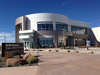
The NCAR-Wyoming Supercomputing Center (NWSC) is a high-performance computing (HPC) and data archival facility located in Cheyenne, Wyoming, that provides advanced computing services to researchers in the Earth system sciences.
The Cheyenne supercomputer at the NCAR-Wyoming Supercomputing Center (NWSC) in Cheyenne, Wyoming operated for seven years as one of the world’s most powerful and energy-efficient computers from 2017 to 2024. Ranked in November 2016 as the 20th most powerful computer in the world and November 2023 as 160th by Top500, the 5.34-petaflops system is capable of more than triple the amount of scientific computing performed by NCAR’s previous supercomputer, Yellowstone. It also is three times more energy efficient than Yellowstone, with a peak computation rate of more than 3 billion calculations per second for every watt of energy consumed.