
Lake Michigan is one of the five Great Lakes of North America. It is the second-largest of the Great Lakes by volume and the third-largest by surface area, after Lake Superior and Lake Huron. To the east, its basin is conjoined with that of Lake Huron through the 3+1⁄2-mile (5.6-kilometer) wide, 295-foot deep Straits of Mackinac, giving it the same surface elevation as its easterly counterpart; geologically, the two bodies are a single lake that is, by area, the largest freshwater lake in the world.

The Andaman Sea is a marginal sea of the northeastern Indian Ocean bounded by the coastlines of Myanmar and Thailand along the Gulf of Martaban and the west side of the Malay Peninsula, and separated from the Bay of Bengal to its west by the Andaman Islands and the Nicobar Islands. Its southern end is at Breueh Island just north of Sumatra, with the Strait of Malacca further southeast.

In oceanography, geomorphology, and geoscience, a shoal is a natural submerged ridge, bank, or bar that consists of, or is covered by, sand or other unconsolidated material, and rises from the bed of a body of water close to the surface or above it, which poses a danger to navigation. Shoals are also known as sandbanks, sandbars, or gravelbars. Two or more shoals that are either separated by shared troughs or interconnected by past or present sedimentary and hydrographic processes are referred to as a shoal complex.

The Palm Islands consist of three artificial archipelagos: Palm Jumeirah, Deira Islands, and Palm Jebel Ali, on the coast of Dubai, United Arab Emirates. The Palm Islands were constructed around the same time as The World Islands. Nakheel Properties is the Palm Islands real estate developer. The creation of the islands began in 2001 and ended around 2006/2007. These islands have significantly impacted ocean sediment and wildlife in the surrounding area.
IslaHuivulai is a private island located five kilometers off the coast of the Mexican state of Sonora in the Gulf of California.

Onekotan is an uninhabited volcanic island located near the northern end of the Kuril Islands chain in the Sea of Okhotsk in the northwest Pacific Ocean. Its name is derived from the Ainu language for "large village”. It is the second largest island, after Paramushir, in the northern subgroup of the Kurils. It is administratively included in the Severo-Kurilsky District of Sakhalin oblast, Russia.
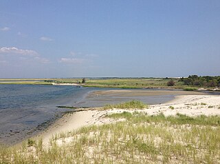
Island Beach State Park is a New Jersey state park located just south of Seaside Park on the Barnegat Peninsula in Berkeley Township, Ocean County, New Jersey, United States. The park is operated and maintained by the New Jersey Division of Parks and Forestry. Most of the park encompasses the former borough of Island Beach.

Cap de Formentor is the northernmost point of Mallorca, on the Formentor peninsula.
The Si Phan Don is a riverine archipelago in the Mekong River, Champasak Province in southern Laos. Si Phan Don is part of Khong District, including the islands and part of the mainland in the east. Si Phan Don is dotted with numerous islands, half of which are submerged when the Mekong River is in flood. The principal islands of Si Phan Don are Don Khong, Don Som, Don Det and Don Khon. Si Phan Don borders Cambodia and historical and cultural ties link the people on both side of the border. Pakse is the closest of the bigger cities in Laos to the area.
Beach evolution occurs at the shoreline where sea, lake or river water is eroding the land. Beaches exist where sand accumulated from centuries-old, recurrent processes that erode rocky and sedimentary material into sand deposits. River deltas deposit silt from upriver, accreting at the river's outlet to extend lake or ocean shorelines. Catastrophic events such as tsunamis, hurricanes, and storm surges accelerate beach erosion.

Sharp Island or Kiu Tsui Chau is the largest island in the Kiu Tsui Country Park located at Port Shelter of Sai Kung, Hong Kong. The area is most known for fishing, swimming as well as diving. Sharp Island is under the administration of Sai Kung District.

Nan'ao or Nanao, formerly romanized Namoa, is an island and county of the prefecture-level city of Shantou in Guangdong Province, China. The county spans a land area of 114.74 square kilometres (44.30 sq mi), and sea area of 4,600 square kilometres (1,800 sq mi). As of 2019, the county had a permanent population of approximately 62,600.
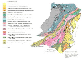
The geology of Delaware consists of two physiographic provinces located in the U.S. state of Delaware. They are the Atlantic Coastal Plain and the Piedmont.

The Helgoland underwater laboratory (UWL) is an underwater habitat. It was built by Dräger in Lübeck, Germany in 1968 for the Biological Institute Helgoland, and was the first of its kind in the world built for use in colder waters. It is named after the island Helgoland.

San Andrés is a coral island in the Caribbean Sea. Politically part of Colombia, and historically tied to the United Kingdom, San Andrés and the nearby islands of Providencia and Santa Catalina form the department of San Andrés, Providencia and Santa Catalina. San Andrés, in the southern group of islands, is the largest of Colombia. The official languages of the department are Spanish, English, and San Andrés–Providencia Creole.

Lian Island is the largest island in Lianyun District, Lianyungang, Jiangsu, China. The island is located inside Haizhou Bay in the Yellow Sea. It is 9 km (5.6 mi) long from east to west across the island and it has an area of 7.57 km2 (2.92 sq mi). 80% of the island is covered with forests. The longest sea dyke nationally connects the island with the east of the city of Lianyungang. Lian Island is the only AAAA-class seashore tourist attraction in Jiangsu. The island was formerly known as Yingyou hill.
Basavaraj Durga Island is an island in the Arabian Sea near Honnavar. It is part of Honnavar Taluk in Karnataka State of India.

Lake Akdoğan, also called Lake Hamurpert, is the name of two neighbouring Crater lakes on the Akdoğan Mountains in Turkey. They are separated by a land strip of about 210 metres (690 ft). They are both high-altitude lakes located in Varto district of Muş Province.

Pink Bay is a bay in the Australian state of South Australia and is located at the east end of Dudley Peninsula on Kangaroo Island overlooking Backstairs Passage in the gazetted locality of Willoughby about 110 kilometres (68 mi) south of the state capital of Adelaide and about 20 kilometres (12 mi) east of Penneshaw.
Mauds Landing is a historic beach located approximately 3 kilometers north of Coral Bay, Western Australia. The site was initially intended as a port for wool and livestock transportation. Presently, it stands as a vital nesting site for Green and Loggerhead turtles, with remnants of its past still evident along the coastline.
