
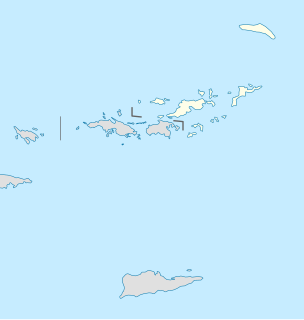
Geography of the United States Virgin Islands
Little Torch Key is an island in the lower Florida Keys. It is a small, quiet Key with easy access to Key West. For divers, the incredible corals of Looe Key National Marine Sanctuary are only a few miles away. The exclusive resort, Little Palm Island, is located just offshore of Little Torch Key. U.S. Route 1, crosses the key at approximately mile markers 28—29. It is immediately preceded to the northeast by Big Pine Key, and is followed by Middle Torch Key to the southwest.

Cruz Bay, U.S. Virgin Islands is the main town on the island of Saint John in the United States Virgin Islands. According to the 2000 Census, Cruz Bay has a population of 2,743 people.

Trunk Bay is a body of water and a beach on St. John in the United States Virgin Islands. Trunk Bay is part of the Virgin Islands National Park. Trunk Bay is named for the Leatherback turtle, which is endemic to the U.S.V.I. and is locally known as trunks. The beach area is divided into two halves, the main Trunk Bay beach and swim area and Burgesman Cove which is located on the west end of Trunk Bay near Jumby Bay. Its amenities include a snack bar, showers and restrooms, a lifeguard, and an underwater trail for snorkeling its coral reef. Trunk Bay has consistently been voted one of the top beaches in the world.

Horseshoe Bay is a well-known beach in Bermuda. As a tourist spot, it lies on the main island's south coast, in the parish of Southampton. It is one of two beaches of the same name in Bermuda, with the other located at Tucker's Island: since the 1940s part of a peninsula that housed the former US Naval Operating Base, and is now called Morgan's Point.

Tobacco Bay is located in the far north of Bermuda. It lies on the Atlantic Ocean coast, close to the town of St. George's and to the historic Fort St. Catherine. One of Bermuda's national parks, it is a popular public beach. Snorkelling is a popular activity, as the bay has impressive underwater coral reefs, which explains its popularity with those who snorkel.
Adams Key is an island north of the upper Florida Keys in Biscayne National Park. It is in Miami-Dade County, Florida. It is located west of the southern tip of Elliott Key, on the north side of Caesar Creek in the lower part of Biscayne Bay. The key is only accessible by boat, and overnight docking is prohibited.
Waterlemon Cay is a small cay surrounded by a fringing reef located in Leinster Bay on Saint John, U.S. Virgin Islands. It is named after the water lemon.
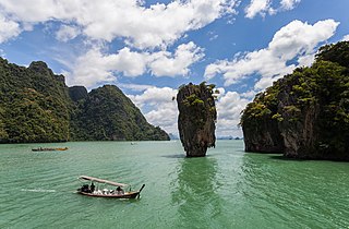
Ao Phang Nga National Park is in Phang Nga Province in southern Thailand. It includes coastal sections of Mueang Phang Nga District and Takua Thung District. Most of the park consists of an area of the Andaman Sea studded with numerous limestone tower karst islands. The best known of these islands is Khao Phing Kan, popularly called "James Bond Island" because it was used as a location for the James Bond movie The Man with the Golden Gun.

Palestina is a settlement on the island of St. John in the United States Virgin Islands. It is located in the east of the island on the coast of Coral Bay, to the east of the town of Coral Bay.

The Hawai`i Institute of Marine Biology (HIMB) is a marine biology laboratory located on the state-owned Coconut Island in Kāne'ohe Bay.

Sahl Hasheesh is a bay located on the Red Sea coast of Egypt, across from Sharm El Sheik, approximately 18 km south of Hurghada International Airport.
Carolina is a neighborhood on the island of Saint John in the United States Virgin Islands. It is located in the hills to the west of Coral Bay.
Hermitage is an area of Virgin Islands National Park on the island of Saint John in the United States Virgin Islands. It is located along the north side of Coral Bay, between the town of Coral Bay and the island's inhabited East End. The mangroves of Princess Bay, inside the National Park, are a popular kayaking and snorkeling spot.
Johns Folly is a neighborhood on the island of Saint John in the United States Virgin Islands. It is located on the east side of the island, south of Coral Bay and north of Salt Pond Bay.

Steven Cay is a small scrub-covered and rocky Caribbean island, about 28 feet high and situated 0.5 miles west of Cruz Bay on Saint John in the United States Virgin Islands. It is a popular destination for snorkelers and scuba divers, and its waters feature coral reefs and sea fans, mountain corals, star corals, large quantities of angel- and triggerfish, as well as lobsters, nurse sharks and pillar corals.

Trunk Cay is a small grass-covered islet in Trunk Bay in the United States Virgin Islands. It has an elevation of 48 feet and is situated only 200 feet from Trunk Bay Beach. It is an islet of rocky cliffs, coral sandy beaches, and palm trees. The Virgin Islands National Park Service offers underwater snorkeling trails around the cay. Trunk Cay is named for the Leatherback turtle, which is endemic to the U.S.V.I. and is locally known as trunks.
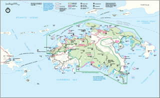
Leduck Island is an island in the United States Virgin Islands, also spelled LeDuck Island, which is located 0.5 miles east of Sabbat Point in Johns Folly, separated from Saint John by the Sabbat Channel. LeDuck Island lies by the entrance to Coral Bay and is 85 feet high. Leduck Island is located within the Virgin Islands National Park and is one of the largest offshore islands to Saint John, along with Grass Cay and Congo Cay. Being home to numerous spur and groove reefs, it is a popular scuba diving destinations and its reefs are habitat for an abundance for endemic tropical fish species. Some of the fish species found here include the Fairy basslet, Sergeant major, French angelfish, Gray angelfish, Queen triggerfish, Jackknife-fish, Blue chromis, Schoolmaster snapper, Mangrove snapper, Red hind, Blacktip shark, Hawksbill sea turtle, Glassy sweeper, Squirrelfish, and numerous species of damsels and jacks.

East End is an administrative subdistrict of the island of Saint Thomas in the United States Virgin Islands. The largest community here is Red Hook, while smaller communities include Benner, Nazareth, Nadir, Frydendal, and Smith Bay. Some of the offshore islands here include Great Saint James Island, Little Saint James Island, Bovoni Cay, Patricia Cay, Cas Cay, Rotto Cay, Thatch Cay, Shark Island, and Dog Island. The East End subdistrict received 731 new residents between the 2000 U.S. Census and the 2010 U.S. Census, and has a 2010 population of 6,658. The East End region offers a more secluded character and less population density than subdistricts as Charlotte Amalie, Southside, and the Tutu subdistricts. This subdistrict is home to numerous of the islands’ largest resorts, in addition to many shopping areas and entertainment venues, as well as the Coral World Marine Park & Underwater Observatory in Coki Point, which is the most popular tourist attraction on Saint Thomas. East End is located about 7.4 miles east of the territorial capital of Charlotte Amalie, which is an approximately thirty-minute drive on the windy, small and narrow Saint Thomas roads. There are buses and taxis leaving from the East End. A typical fare for a taxi drive to the capital costs $20. The hotels on Saint Thomas are evenly divided between the two subdistricts of Charlotte Amalie, and the more expensive resort-style hotels by their own beachside in East End. The East End resorts are therefore generally more expensive than those found elsewhere on the island. Some of the famous beaches found here are Lindquist- and Sapphire Beaches, while others include Pineapple Beach and Vessup Beach amongst others.
Oil Nut Bay is a coral reef bay situated on the northeast coast of Virgin Gorda in the British Virgin Islands, about 1 kilometre (0.62 mi) west of Pajaros Point.

