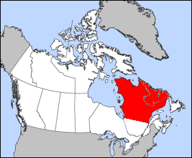
The Labrador Peninsula, also known as the Quebec-Labrador Peninsula, is a large peninsula in eastern Canada. It is bounded by Hudson Bay to the west, the Hudson Strait to the north, the Labrador Sea to the east, and the Gulf of Saint Lawrence to the southeast. The peninsula includes the region of Labrador, which is part of the province of Newfoundland and Labrador, and the regions of Saguenay–Lac-Saint-Jean, Côte-Nord, and Nord-du-Québec, which are in the province of Quebec. It has an area of 1,400,000 km2 (541,000 sq mi).
Caniapiscau is a vast unorganized territory in the Côte-Nord region of Quebec, Canada, part of Caniapiscau Regional County Municipality.

Sept-Rivières is a regional county municipality of Quebec, Canada, in the Côte-Nord region. Its county seat is Sept-Îles.

The James Bay Project refers to the construction of a series of hydroelectric power stations on the La Grande River in northwestern Quebec, Canada by state-owned utility Hydro-Québec, and the diversion of neighbouring rivers into the La Grande watershed. It is located between James Bay to the west and Labrador to the east, and its waters flow from the Laurentian Plateau of the Canadian Shield. The project covers an area the size of New York State and is one of the largest hydroelectric systems in the world. It has cost upwards of US$20 billion to build and has an installed generating capacity of 15,244 megawatts, at the cost of 7,000 square miles of Cree hunting lands. If fully expanded to include all of the original planned dams, as well as the additional James Bay II projects, the system would generate a total of 27,000 MW, making it the largest hydroelectric system in the world. It has been built since 1974 by James Bay Energy (SDBJ) for Hydro-Québec.
Chateauguay may refer to:
La Grande River is a river in northwestern Quebec, Canada, rising in the highlands of the north-central part of the province and flowing roughly 900 km (560 mi) west to its drainage at James Bay. It is the second-longest river in the province, surpassed only by the Saint Lawrence River.

The Koksoak River is a river in northern Quebec, Canada, the largest river in the Nunavik region. The Inuit village and region's administrative centre Kuujjuaq lies on the shores of the Koksoak, about 50 kilometres (31 mi) south from its mouth.
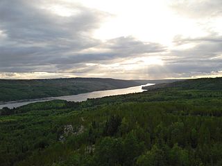
The Caniapiscau River is a tributary of the Koksoak River in Nunavik, Quebec, Canada. In Cree the name of the river means rocky point.
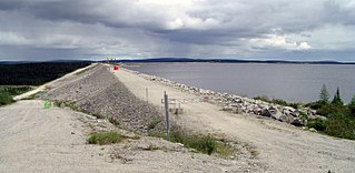
The Caniapiscau Reservoir is a reservoir on the upper Caniapiscau River in the Côte-Nord administrative region of the Canadian province of Quebec. It is the largest body of water in Quebec and the second largest reservoir in Canada.

Radisson is a small unconstituted locality situated near the Robert-Bourassa hydroelectric power station on the La Grande River in the James Bay region of Quebec, Canada. Geographically, Radisson is located halfway between the southern and northernmost points in Quebec and is, besides Schefferville, the only non-native town north of the 53rd parallel in this province.

The migratory woodland caribou refers to two herds of Rangifer tarandus that are included in the migratory woodland ecotype of the subspecies Rangifer tarandus caribou or woodland caribou that live in Nunavik, Quebec, and Labrador: the Leaf River caribou herd (LRCH) and the George River caribou herd (GRCH) south of Ungava Bay. Rangifer tarandus caribou is further divided into three ecotypes: the migratory barren-ground ecotype, the mountain ecotype or woodland (montane) and the forest-dwelling ecotype. According to researchers, the "George River herd which morphologically and genetically belong to the woodland caribou subspecies, at one time represented the largest caribou herd in the world and migrating thousands of kilometers from boreal forest to open tundra, where most females calve within a three-week period. This behaviour is more like barren-ground caribou subspecies." They argued that "understanding ecotype in relation to existing ecological constraints and releases may be more important than the taxonomic relationships between populations." The migratory George River caribou herd travel thousands of kilometres moving from wintering grounds to calving grounds near the Inuit hamlet of Kangiqsualujjuaq, Nunavik. In Nunavik and Labrador, the caribou population varies considerably with their numbers peaking in the later decades of each of the 18th, 19th and 20th centuries. In 1984, about 10,000 caribou of the George River herd drowned during their bi-annual crossing of the Caniapiscau River during the James Bay Hydro Project flooding operation. The most recent decline at the turn of the 20th century caused much hardship for the Inuit and Cree communities of Nunavik, who hunt them for subsistence.

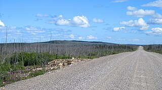
The Trans-Taiga Road is an extremely remote wilderness road in northern Quebec, Canada. It is 582 kilometres (362 mi) long to Centrale Brisay and another 84 kilometres (52 mi) along the Caniapiscau Reservoir, all of it unpaved.

The Brisay hydroelectric generating station is on the Caniapiscau Reservoir, in the Canadian province of Quebec. Part of Hydro-Québec's James Bay Project, the station can generate 469 MW. It was commissioned in 1993. It generates electricity through the reservoir and dam system.
Lake Bermen is a 103 square kilometres (40 sq mi) lake in the province of Quebec, Canada. The lake is on ancient rocks of the Superior Province where gold mineralization has been found. It is named after Claude de Bermen de la Martinière (1636–1719), a senior official in New France.
Rivière-Mouchalagane is an unorganized territory in the Côte-Nord region of Quebec, Canada, part of Caniapiscau Regional County Municipality.

The Hart Jaune River is a river in Quebec, Canada. It flows from the Petit lac Manicouagan to the Manicouagan Reservoir.
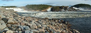
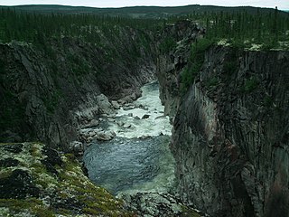
Limestone Falls is series of waterfalls on the Caniapiscau River in Nunavik, Quebec, Canada. The falls are both the largest and tallest of a series of waterfalls on the Caniapiscau River, which includes the smaller but equally powerful Pyrite Falls located about 7 km (4.3 mi) upstream.
The Mouchalagane River is a river in the Côte-Nord region of Quebec, Canada. It feeds the Manicouagan Reservoir.