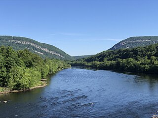
The Delaware River is a major river in the Mid-Atlantic region of the United States and is the longest free-flowing (undammed) river in the Eastern United States. From the meeting of its branches in Hancock, New York, the river flows for 282 miles (454 km) along the borders of New York, Pennsylvania, New Jersey, and Delaware, before emptying into Delaware Bay.
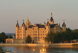
Schwerin is the capital and second-largest city of the northeastern German state of Mecklenburg-Vorpommern as well as of the region of Mecklenburg, after Rostock. It has around 96,000 inhabitants, and is thus the least populous of all German state capitals.

Fishers is a city in Fall Creek and Delaware townships in Hamilton County, Indiana, United States. As of the 2020 census the population was 98,677. A suburb of Indianapolis, Fishers has grown rapidly in recent decades: about 350 people lived there in 1963, 2,000 in 1980, and only 7,500 as recently as 1990.

Morrisville is a borough in Bucks County, Pennsylvania, United States. It is located just below the falls of the Delaware River opposite Trenton, New Jersey. The population was 9,809 in the 2020 Census.

Bartlesville is a city mostly in Washington County and Osage County, Oklahoma. The population was 37,290 at the 2020 census. Bartlesville is 47 miles (76 km) north of Tulsa and 18 miles (29 km) south of the Kansas border. It is the county seat of Washington County. The Caney River runs through Bartlesville.

Beatrice Wood was an American artist and studio potter involved in the Dada movement in the United States; she founded and edited The Blind Man and Rongwrong magazines in New York City with French artist Marcel Duchamp and writer Henri-Pierre Roché in 1917. She had earlier studied art and theater in Paris, and was working in New York as an actress. She later worked at sculpture and pottery. Wood was characterized as the "Mama of Dada".

The Pan-American Exposition was a world's fair held in Buffalo, New York, United States, from May 1 through November 2, 1901. The fair occupied 350 acres (0.55 sq mi) of land on the western edge of what is now Delaware Park, extending from Delaware Avenue to Elmwood Avenue and northward to Great Arrow Avenue. It is remembered today primarily for being the location of the assassination of United States President William McKinley at the Temple of Music on September 6, 1901. The exposition was illuminated at night. Thomas A. Edison, Inc. filmed it during the day and a pan of it at night.
The du Pont family or Du Pont family is a prominent American family descended from Pierre Samuel du Pont de Nemours (1739–1817), a French minor aristocrat. It has been one of the richest families in the United States since the mid-19th century, when it founded its fortune in the gunpowder business. In the late 19th and early 20th centuries, it expanded its wealth through the chemical industry and the automotive industry, with substantial interests in the DuPont company, General Motors, and various other corporations.

Around the World in 80 Days is a 1956 American epic adventure-comedy film starring David Niven, Cantinflas, Robert Newton and Shirley MacLaine, produced by the Michael Todd Company and released by United Artists.

Charles Vess is an American fantasy artist and comics artist who has specialized in the illustration of myths and fairy tales. His influences include British "Golden Age" book illustrator Arthur Rackham, Czech Art Nouveau painter Alphonse Mucha, and comic-strip artist Hal Foster, among others. Vess has won several awards for his illustrations. Vess' studio, Green Man Press, is located in Abingdon, VA.

The Big Trail is a 1930 American epic pre-Code Western early widescreen film shot on location across the American West starring 23-year-old John Wayne in his first leading role and directed by Raoul Walsh. It is the final completed film to feature Tyrone Power Sr. before his death in 1931, as well as his only sound role.
Bridgeville is a hamlet southeast of Monticello located in the southern Catskill Mountains in the Town of Thompson, County of Sullivan, and State of New York, United States. Bridgeville is located on the Neversink River on New York State Route 17, at an elevation of 1,081 feet (329 m). It has hilly terrain.
70 mm Grandeur film, also called Fox Grandeur or Grandeur 70, is a 70 mm widescreen film format developed by William Fox through his Fox Film and Fox-Case corporations and used commercially on a small but successful scale in 1929–30.

Rondout Reservoir is part of New York City's water supply network. It is located 75 miles (121 km) northwest of the city in the Catskill Mountains, near the southern end of Catskill Park, split between the towns of Wawarsing in Ulster County and Neversink in Sullivan County. It is the central collection point for the city's Delaware System, which provides half its daily consumption.

Neversink Reservoir is a reservoir in the New York City water supply system. It is located in the Catskill Mountain town of Neversink in Sullivan County, New York, 75 miles (121 km) northwest of the City.

The Delaware Art Museum is an art museum located on the Kentmere Parkway in Wilmington, Delaware, which holds a collection of more than 12,000 objects. The museum was founded in 1912 as the Wilmington Society of the Fine Arts in honor of the artist Howard Pyle. The collection focuses on American art and illustration from the 19th to the 21st century, and on the English Pre-Raphaelite Brotherhood movement of the mid-19th century.

The Schoharie Reservoir is a reservoir in the Catskill Mountains of New York State that was created to be one of 19 reservoirs that supplies New York City with water. It was created by impounding Schoharie Creek. Portions of it lie in the towns of Conesville and Gilboa in Schoharie County, Roxbury in Delaware County, and Prattsville in Greene County.

The Cannonsville Reservoir is a reservoir in the New York City water supply system in Delaware County, New York. It was formed by construction of the Cannonsville Dam on its west end, which impounded over half of the West Branch of the Delaware River. Lying on the western part of the Delaware Watershed, it is the westernmost of New York City's reservoirs. It was placed in service in 1964, and is the most recently constructed New York City-owned reservoir.
Robert Beavers is an American experimental filmmaker. Born and raised in Massachusetts, he attended Deerfield Academy which he left before graduating to move to New York in 1965 to pursue filmmaking. He lived in New York until 1967 when he and his partner, Gregory Markopoulos, left the United States for Europe, where they continued to live and make films until Markopoulos's death in 1992.

A Modern Musketeer is a 1917 American silent adventure comedy film directed and written by Allan Dwan. Based on the short story, "D'Artagnan of Kansas" by Eugene P. Lyle, Jr., which appeared in Everybody's Magazine, September 1912, the film was produced by and stars Douglas Fairbanks. A now complete and restored print of the film still exists and is currently in the public domain.
