Related Research Articles

Kiowa is a home rule municipality town and the county seat of Elbert County, Colorado, United States. The town population was 725 at the 2020 United States Census.

The Gallatin River is a tributary of the Missouri River, approximately 120 mi (193 km) long, in the U.S. states of Wyoming and Montana. It is one of three rivers, along with the Jefferson and Madison, that converge near Three Forks, Montana, to form the Missouri.

The Teton River is a 64-mile-long (103 km) tributary of the Henrys Fork of the Snake River in southeastern Idaho in the United States. It drains through the Teton Valley along the west side of the Teton Range along the Idaho-Wyoming border at the eastern end of the Snake River Plain. Its location along the western flank of the Tetons provides the river with more rainfall than many other rivers of the region.

The Feather River is the principal tributary of the Sacramento River, in the Sacramento Valley of Northern California. The river's main stem is about 73 miles (117 km) long. Its length to its most distant headwater tributary is just over 210 miles (340 km). The main stem Feather River begins in Lake Oroville, where its four long tributary forks join—the South Fork, Middle Fork, North Fork, and West Branch Feather Rivers. These and other tributaries drain part of the northern Sierra Nevada, and the extreme southern Cascades, as well as a small portion of the Sacramento Valley. The total drainage basin is about 6,200 square miles (16,000 km2), with approximately 3,604 square miles (9,330 km2) above Lake Oroville.
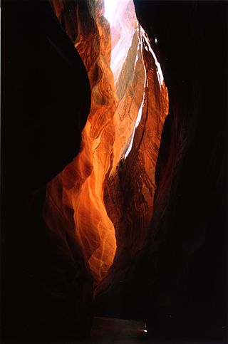
Buckskin Gulch is a gulch and canyon located in southern Kane County, Utah, near the Arizona border in the Paria Canyon-Vermilion Cliffs Wilderness. With a length of over 16 miles (26 km), it is one of the main tributaries of the Paria River, a tributary of the Colorado River.

Sycamore Canyon is the second largest canyon in the Arizona redrock country, after Oak Creek Canyon. The 21-mile (34 km) long scenic canyon reaches a maximum width of about 7 miles (11 km). It is in North Central Arizona bordering and below the Mogollon Rim, and is located west and northwest of Sedona in Yavapai and Coconino counties.

The Grand Loop Road is a historic district which encompasses the primary road system in Yellowstone National Park. Much of the 140-mile (230 km) system was originally planned by Captain Hiram M. Chittenden of the US Army Corps of Engineers in the early days of the park, when it was under military administration. The Grand Loop Road provides access to the major features of the park, including the Upper, Midway and Lower geyser basins, Mammoth Hot Springs, Tower Fall, the Grand Canyon of the Yellowstone and Yellowstone Lake.

Temescal Creek is an approximately 29-mile-long (47 km) watercourse in Riverside County, in the U.S. state of California. Flowing primarily in a northwestern direction, it connects Lake Elsinore with the Santa Ana River. It drains the eastern slopes of the Santa Ana Mountains on its left and on its right the western slopes of the Temescal Mountains along its length. With a drainage basin of about 1,000 square miles (2,600 km2), it is the largest tributary of the Santa Ana River, hydrologically connecting the 720-square-mile (1,900 km2) San Jacinto River and Lake Elsinore watersheds to the rest of the Santa Ana watershed. However, flowing through an arid rain shadow zone of the Santa Ana Mountains, and with diversion of ground water for human use, the creek today is ephemeral for most of its length, except for runoff from housing developments and agricultural return flows.

The Teton Crest Trail is a 40-mile (64 km) long hiking trail in the U.S. state of Wyoming that extends from Phillips Pass, on the border of Bridger Teton and Caribou-Targhee National Forests, to String Lake in Grand Teton National Park. Backpacker Magazine calls the Trail one of the "Best Hikes Ever," with "mesmerizing and constant views of jagged peaks."
The Owl Creek Trail is a 7.3-mile (11.7 km) long hiking trail in the far northern region of Grand Teton National Park in the U.S. state of Wyoming.
The Webb Canyon Trail is a 9.9-mile (15.9 km) long hiking trail in the far northern region of Grand Teton National Park in the U.S. state of Wyoming. The trail begins near the National Park Service backcountry patrol cabin near Wilcox Point on Jackson Lake. Located in the remote northern backcountry of Grand Teton National Park, the trail is not connected to maintained trails in the southern part of the park and must be accessed from the Glade Creek trailhead in the John D. Rockefeller, Jr. Memorial Parkway. From Glade Creek, it is a 7.5 mi (12.1 km) hike to the patrol cabin and the beginning of the Webb Canyon Trail. The trail follows Moose Creek west and after several miles, is flanked by both Owl Peak and Elk Mountain to the north and several unnamed peaks nearing 11,000 ft (3,400 m) to the south. At Moose Basin Divide the trail meets the Owl Creek Trail.

The Death Canyon Trail is a 10.5 mi (16.9 km) long hiking trail in Grand Teton National Park in the U.S. state of Wyoming.
The Lake Solitude Trail is a 4.8-mile (7.7 km) long hiking trail in Grand Teton National Park in the U.S. state of Wyoming. The trail begins at the Forks of Cascade Canyon and follows Cascade Creek up through North Cascade Canyon to Lake Solitude. Beyond Lake Solitude, the trail becomes steep and climbs to Paintbrush Divide where it ends at the Paintbrush Canyon Trail. The only way to access the trail is by way of either the Paintbrush Canyon or Cascade Canyon Trails. Except at and above Lake Solitude, backcountry camping is allowed with a permit along the trail. At South Jenny Lake, a boat shuttle operates during the summer which shortens the hike by 4 miles (6.4 km). The Lake Solitude Trail is part of a popular 19-mile (31 km) long loop hike which runs through both Cascade and Paintbrush Canyons.
Death Canyon Shelf is a narrow plateau located in Grand Teton National Park in the U.S. state of Wyoming. The plateau extends from Fox Creek Pass to Mount Meek Pass, a distance of almost 4 miles (6.4 km). The Death Canyon Shelf parallels much of Death Canyon to the east and has cliffs rising several hundred feet to the west for most of the shelf's length. Camping is permitted on Death Canyon Shelf with a permit. The shelf is traversed by the Teton Crest Trail for its entire length, but it is deep in the backcountry, requiring a 10-mile (16 km) hike from the Death Canyon trailhead to access.

Laguña Creek also formerly also known as Tyende Creek, is a stream in the Navajo and Apache Counties of Arizona. Laguña Creek has its source at 36°41′15″N110°30′36″W, at the confluence of Long Canyon and Dowozhiebito Canyon at an elevation of 6,325 feet at the head of Tsegi Canyon. Its mouth is in the Chinle Valley at its confluence with Chinle Wash which together forms Chinle Creek, at an elevation of 4,774 feet. Chinle Creek is a tributary of San Juan River which is in turn a tributary of the Colorado River.
Willow Creek is a tributary stream of the Jordan River, in Salt Lake County, Utah.
Bluewater Creek is a stream in northern Butler and southern Wayne counties in the U.S. state of Missouri. It is a tributary of Asher Creek.
Crooks Springs is an unincorporated community in southern St. Clair County, in the U.S. state of Missouri. The community is on Allen Branch a tributary of the Sac River approximately twelve miles southwest of Osceola.
References
43°55′01″N111°27′46″W / 43.91694°N 111.46278°W
| | This article related to a river in Idaho is a stub. You can help Wikipedia by expanding it. |