Southeast Alaska, colloquially referred to as the Alaska Panhandle or Alaskan Panhandle, is the southeastern portion of the U.S. state of Alaska, bordered to the east by the northern half of the Canadian province of British Columbia. The majority of Southeast Alaska's area is part of the Tongass National Forest, the United States' largest national forest. In many places, the international border runs along the crest of the Boundary Ranges of the Coast Mountains. The region is noted for its scenery and mild rainy climate.

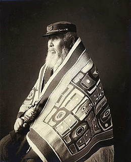
The Tlingit are indigenous peoples of the Pacific Northwest Coast of North America. Their language is the Tlingit language, in which the name means "People of the Tides". The Russian name Koloshi or the related German name Koulischen may be encountered referring to the people in older historical literature, such as Shelikhov's 1796 map of Russian America.

Ketchikan is a city in and the borough seat of the Ketchikan Gateway Borough of Alaska. It is the state's southeasternmost major settlement. Downtown Ketchikan is a National Historic District. With a population at the 2010 census of 8,050, it is the fifth-most populous city in the state, and tenth-most populous community when census-designated places are included. The surrounding borough, encompassing suburbs both north and south of the city along the Tongass Highway, plus small rural settlements accessible mostly by water, registered a population of 13,477 in that same census. Estimates put the 2017 population at 13,754 people. Incorporated on August 25, 1900, Ketchikan is the earliest extant incorporated city in Alaska, because consolidation or unification elsewhere in Alaska resulted in dissolution of those communities' city governments. Ketchikan is located on Revillagigedo Island, so named in 1793 by Captain George Vancouver.

Unimak Island is the largest island in the Aleutian Islands chain of the U.S. state of Alaska.

Aleksei Ilyich Chirikov was a Russian navigator and captain who along with Bering was the first Russian to reach North-West coast of North America. He discovered and charted some of the Aleutian Islands while he was deputy to Vitus Bering during the Great Northern Expedition.

Revillagigedo Island is an island in the Alexander Archipelago in Ketchikan Gateway Borough of the southeastern region of the U.S. state of Alaska. Running about 89 km (50 mi) north-south and 48 km (35 mi) east-west, it is 2,754.835 km² (1,063.65 mi²) in area, making it the 12th largest island in the United States and the 167th largest island in the world. Its center is located near 55°38′03″N131°17′51″W.

The Alaska Maritime National Wildlife Refuge is a United States National Wildlife Refuge comprising 2,400 islands, headlands, rocks, islets, spires and reefs in Alaska, with a total area of 4.9 million acres (20,000 km2), of which 2.64 million acres (10,700 km2) is wilderness. The refuge stretches from Cape Lisburne on the Chukchi Sea to the tip of the Aleutian Islands in the west and Forrester Island in the southern Alaska Panhandle region in the east. The refuge has diverse landforms and terrains, including tundra, rainforest, cliffs, volcanoes, beaches, lakes, and streams.

MV Matanuska, colloquially known as the Mat, is a mainline Malaspina-class ferry vessel for the Alaska Marine Highway System.

USCGC SPAR (WLB-206) is a United States Coast Guard seagoing buoy tender home-ported in Kodiak, Alaska. The ship maintains aids to navigation in the Aleutian Islands of Alaska, and has acquired the nickname "Aleutian Keeper". SPAR also performs other missions, such as search & rescue and law enforcement operations, in one of the world’s most challenging marine environments from the Gulf of Alaska to the Arctic ocean.
The Alaska Native Tribal Health Consortium (ANTHC) is a non-profit health organization based in Anchorage, Alaska which provides health services to 158,000 Alaska Natives and American Indians in Alaska. Established in 1997, ANTHC is a consortium of the tribal regional health organizations. The Board of Directors for ANTHC equally represent all tribal regions of Alaska and each region has parity. The foundation of tribal region unity and equality provides for the best health care service access for all Alaska Native people.

The Scotch Cap Light is a lighthouse located on the southwest corner of Unimak Island in Alaska. It was the first station established on the outside coast of Alaska.
Alaska Route 7 is a state highway in the Alaska Panhandle of the U.S. state of Alaska. It consists of four unconnected pieces, serving some of the Panhandle communities at which the Alaska Marine Highway ferries stop, and connecting to the Alaska Highway in Yukon via the Haines Highway.
The Adam Mountains, sometimes called the Adam Range, are a small mountain range in the southeastern extremity of the Alaska Panhandle, in the Ketchikan Gateway Borough near the Halleck Range. It has an area of 50 km2 and is a subrange of the Boundary Ranges which in turn form part of the Coast Mountains.

Fort Tongass was a United States Army base on Tongass Island, in the southernmost Alaska Panhandle, located adjacent to the village of the group of Tlingit people on the east side of the island. Fort Tongass was the first US Army base established in Alaska following its purchase from the Russian Empire in 1867 and was garrisoned by the 2nd U.S. Artillery under the command of Captain Charles H. Peirce. Historian Hubert Howe Bancroft notes: "the site was well chosen, containing a plentiful supply of timber and pasture, while fish and game abound in the neighbourhood.

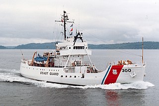
USCGC Citrus (WAGL-300/WLB-300/WMEC-300) was a Cactus (A)-class seagoing buoy tender built in 1942 in Duluth, Minnesota, and now operated by the navy of the Dominican Republic.
USCGC Clover WAGL/WLB/WMEC-292, a Cactus (A) Class buoy tender was built by Marine Iron and Shipbuilding, Duluth, Minnesota. Her keel was laid 3 December 1941, and she was launched 25 April 1942. She was commissioned on 8 November 1942 in the United States Coast Guard as the United States Coast Guard Cutter Clover. She was built as a WAGL, redesignated a WLB in 1965, and again redesignated a WMEC in 1979.

The Totem Heritage Center is a museum operated by the City of Ketchikan in the U.S. state of Alaska.

Pennock Island is located in the U.S. state of Alaska near the city of Ketchikan. The island is situated within the Ketchikan Gateway Borough and is part of the Alexander Archipelago. Most of the island is public land managed by the Tongass National Forest.

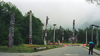
Saxman Totem Park is a public park in the city of Saxman, Alaska, just south of Ketchikan in southeastern Alaska. The park is home to a collection of totem poles, some of which are old poles relocated to this place from abandoned Tlingit villages in the region, or were reconstructed by skilled Tlingit carvers under the auspices of the Civilian Conservation Corps in the 1930s. The poles originated in the communities of Old Tongass, Cat Island, Village Island, Pennock Island, and Fox Village. One of the carved items recovered from abandoned villages is a marble statue of a grizzly bear. The park was listed on the National Register of Historic Places in 1979.


