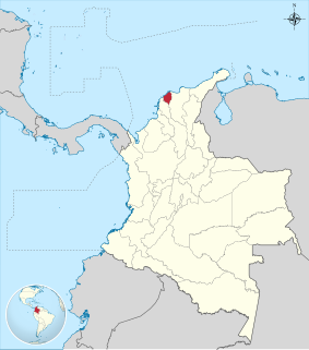
Atlántico is a department of Colombia, located in northern Colombia with the Caribbean Sea to its north, the Bolívar Department to its west and south separated by the Canal del Dique, and the Magdalena Department to its east separated by the Magdalena River. It is the third-smallest of the country's departments but its population of 2,272,170 makes it one of the most densely populated.

Chocó Department is a department of Colombia known for its large Afro-Colombian population. It is in the west of the country, and is the only Colombian department to have coastlines on both the Pacific Ocean and the Atlantic Ocean. It contains all of Colombia's border with Panama. Its capital is Quibdó.

Huila is one of the departments of Colombia. It is located in the southwest of the country, and its capital is Neiva.

Valle del Cauca, or Cauca Valley is a department of Colombia. It is on the western side of the country, abutting the Pacific Ocean. Its capital is Santiago de Cali. Such other cities as Buenaventura, Cartago and Tuluá have great economical, political, social and cultural influence on the department's life. Valle del Cauca has the largest number of independent towns with over 100,000 inhabitants in the country, counting six within its borders. Buenaventura has the largest and busiest seaport in Colombia, moving about 8,500,000 tons of merchandise annually.

The Magdalena River is the principal river of Colombia, flowing northward about 1,528 kilometres (949 mi) through the western half of the country. It takes its name from the biblical figure Mary Magdalene. It is navigable through much of its lower reaches, in spite of the shifting sand bars at the mouth of its delta, as far as Honda, at the downstream base of its rapids. It flows through the Magdalena River Valley.

Montería is a municipality and city located in northern Colombia and is the capital of the Department of Córdoba. The city is located 50 km (31 mi) away from the Caribbean sea, by the Sinú River. The city and region are famous for their distinct cultural heritages, which include a blend of indigenous Zenú Indians, African descendants, colonial Spanish descendants, and more recently, Arab immigrants. The city is home to the Sombrero Vueltiao, a national symbol; and is the home of Porro folklore music. The city has an inland seaport connected to the Caribbean Sea by the Sinú River.

The Tequendama Falls is a 132 metres (433 ft) high waterfall of the Bogotá River, located 32 kilometres (20 mi) southwest of Bogotá in the municipality of Soacha. Established in approximately 10,000 BCE, El Abra and Tequendama were the first permanent settlements in Colombia. One of the country’s tourist attractions, the falls are located in a forested area 32 kilometres (20 mi) west of Bogotá. The river surges through a rocky gorge that narrows to about 18 metres (59 ft) at the brink of the 132 metres (433 ft) high falls. During the month of December the falls become completely dry. The falls, once a common site for suicides, may be reached by road from Bogotá.

The porro is a musical style and dance from the Caribbean region of Colombia. It is a Colombian cumbia rhythm that developed into its own subgenre. It was originally a folkloric expression from the Sinú River area that evolved into a ballroom dance. It is played mostly by brass bands or orchestras, and danced in couples. This genere influenced some of the greatest Latin American Bands of the 60's, with songs such as "Pachito E'ché", "Se va el Caimán", and "Me voy pa'Cataca"

Adolfo Alfredo Pedernera, born in Avellaneda, Argentina, was a football player and coach. Nicknamed "El Maestro", He was widely considered to be one of the greatest world football players in the 1940s, as well as one of the Argentine players of all-time. Pedernera was the natural conductor of both famous River Plate team known as La Máquina, with whom he won several Argentine and South American titles, and Millonarios team called Ballet Azul, with which won the Small Club World Cup in 1953 among many others colombian titles. Playing for the Argentine Team he won three times the Copa América in 1941, 1945 and 1946, being awarded as the Best Player of the latter. He also was elected the 12th best South american footballer of the 20th century in a poll by the IFFHS in 2000, and his name appears in the list of the 100 greatest all-time footballers selected from the magazine FourFourTwo in 2017, in which he holds the 58th place.

Radamel Falcao García Zárate is a Colombian professional footballer who plays as a forward for and captains both Monaco and the Colombia national team. He is sometimes nicknamed "El Tigre" or "King of the Europa League".

Nevado del Huila at 5,364 metres (17,598 ft), is the highest volcano in Colombia, located at the tripoint of the departments of Huila, Tolima and Cauca. It is visible from the city of Cali. The andesitic volcano is located on top of the Ibagué Batholith.

North Santander is a department of the nation of Colombia. It is in the north of the country, bordering Venezuela. Its capital is Cúcuta, one of the country's major cities.

The Tuparro National Natural Park is a national park located in the Vichada Department in the Orinoquía Region of Colombia. It is the only protected area in the Eastern Plains under Colombia's Natural Parks System.

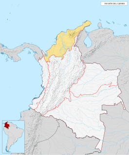
The Caribbean region is mostly lowland plains extending from the northern reaches of the Colombian Andes to the Caribbean Sea that are characterized by a variety of ecosystems including: humid forests, dry forests, savannas, wetlands and desert. The Sierra Nevada de Santa Marta rise from the plains to snow-capped peaks, separated from the Andes as an isolated area of high biodiversity and endemism. It contains one of the largest marshes in Colombia, the Ciénaga Grande de Santa Marta. The main river is the Magdalena which is fully navigable in the region and a major path for the flow of shipments to and from inland Colombia.

The Colombia–Venezuela border is an ongoing international border of 2,219 kilometers that separates the territories of Colombia and Venezuela, with a total of 603 milestones that demarcate the line. It is the longest border of both Colombia and Venezuela.

Miguel Triana Ruiz de Cote was a Colombian engineer and Muisca scholar. He is best known for his 1922 publication La Civilización Chibcha; "The Muisca civilisation". Triana wrote a number of books about the Muisca and their culture. Miguel Triana especially contributed to the knowledge of the religion, society and the creation of rock art throughout the Muisca Confederation. Triana was the first Colombian investigator relating the Muisca culture with the pictographs. He described hundreds of rock paintings and carvings in his book El jeroglífico Chibcha.

Professor Marianne Vere Cardale de Schrimpff is a Colombian anthropologist, archaeologist, academic and writer.

The Juan Amarillo, Arzobispo, or Salitre River is a river on the Bogotá savanna and a left tributary of the Bogotá River in Colombia. The river originates from various quebradas in the Eastern Hills and flows into the Bogotá River at the largest of the wetlands of Bogotá, Tibabuyes, also called Juan Amarillo Wetland. The total surface area of the Juan Amarillo basin, covering the localities Usaquén, Chapinero, Santa Fe, Suba, Barrios Unidos, Teusaquillo, and Engativá, is 12,892 hectares. Together with the Fucha and Tunjuelo Rivers, the Juan Amarillo River forms part of the left tributaries of the Bogotá River in the Colombian capital.

The Torca River is a river on the Bogotá savanna and a left tributary of the Bogotá River. The river, in a basin of 6,008.69 hectares (23.1997 sq mi), originates in the Eastern Hills of Bogotá at an altitude of 2,837 metres (9,308 ft). It flows in the north of the Colombian capital, through the locality of Usaquén and into the Bogotá River in Suba at the border with Chía, at 2,545 metres (8,350 ft) above sea level. The Torca wetland is located near its mouth.


