
Geography of the United States Virgin Islands

The Virgin Islands are geologically and biogeographically the easternmost part of the Greater Antilles, the northern islands belonging to the Puerto Rican Bank and St. Croix being a displaced part of the same geologic structure. Politically, the British Virgin Islands have been governed as the western island group of the Leeward Islands, which are the northern part of the Lesser Antilles, and form the border between the Caribbean Sea and the Atlantic Ocean. The archipelago is separated from the true Lesser Antilles by the Anegada Passage and from the main island of Puerto Rico by the Virgin Passage.
Greensville County is a county located in the Commonwealth of Virginia. As of the 2010 census, the population was 12,243. Its county seat is Emporia.

Oscarville is a census-designated place (CDP) in Bethel Census Area, Alaska, United States. The population was 70 at the 2010 census, up from 61 in 2000.

Billings Township is a civil township of Gladwin County in the U.S. state of Michigan. As of the 2000 census, the township population was 2,715.

Cruz Bay, U.S. Virgin Islands is the main town on the island of Saint John in the United States Virgin Islands. According to the 2000 Census, Cruz Bay has a population of 2,743 people.
The area code (340) is the local telephone area code of U.S. Virgin Islands. The (340) area code was created during a split from the original (809) area code, which began permissive dialing on 1 June 1997 and ended 30 June 1998.
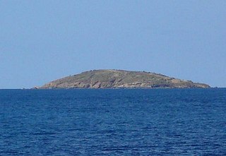
Flanagan Island is an island located within the Virgin Islands archipelago in the Caribbean and forms part of the U.S. Virgin Islands.

The U.S. Virgin Islands Paradise Jam is a college basketball tournament that takes place in late November of each year, with the men usually playing the week before Thanksgiving and the women playing Thanksgiving week. It normally takes place in St. Thomas at the Sports and Fitness Center on the campus of the University of the Virgin Islands.
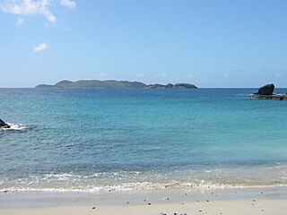
Savana Island is an islet of the United States Virgin Islands. It is located off the West End of St. Thomas at 18°20'N 65°05'W, approximately 7 miles west of Cyril E. King Airport..

Clotho is an unincorporated community in Fresno County, California. It is located on the Southern Pacific Railroad 3 miles (4.8 km) west-northwest of Sanger, at an elevation of 351 feet.
Ingle is an unincorporated community in Fresno County, California. It is located on the Southern Pacific Railroad 7.25 miles (11.7 km) east-southeast of Mendota, at an elevation of 164 feet.
Peterborg is a settlement and peninsula on the Northside of the island of Saint Thomas in the United States Virgin Islands. It overlooks Magens Bay to the southwest and the Atlantic Ocean to the northeast.
Resolution is a settlement on the island of Saint Thomas in the United States Virgin Islands. It is part of the Northside Administrative District. Crown Mountain, the highest point in the US Virgin Islands, is in Resolution.
Sorgenfri is a settlement on the island of Saint Thomas in the United States Virgin Islands.

Annaberg is a former sugar factory and plantation on the island of Saint John in the United States Virgin Islands. It is uninhabited and part of the Annaberg Historic District within the Virgin Islands National Park.
Bordeaux is a neighborhood on the island of Saint John in the United States Virgin Islands. It is named for Mount Bordeaux, the highest point on the island. Most of this area is part of Virgin Islands National Park.
Fish Bay is a bay and neighborhood on the island of Saint John in the United States Virgin Islands. Most of this area is part of Virgin Islands National Park.
Mount Pleasant is an area of Virgin Islands National Park on the island of Saint John in the United States Virgin Islands. It is located between Maho Bay and Centerline Road. This area is uninhabited and its name has fallen out of use.


