
Dumfries and Galloway is one of the 32 unitary council areas of Scotland, located in the western part of the Southern Uplands. It is bordered by East Ayrshire, South Ayrshire, and South Lanarkshire to the north; Scottish Borders to the north-east; the English county of Cumbria, the Solway Firth, and the Irish Sea to the south, and the North Channel to the west. The administrative centre and largest settlement is the town of Dumfries. The second largest town is Stranraer, located 76 miles (122 km) to the west of Dumfries on the North Channel coast.

Dumfriesshire or the County of Dumfries or Shire of Dumfries is a historic county and registration county in southern Scotland. The Dumfries lieutenancy area covers a similar area to the historic county.

Nithsdale, also known as Strathnith, Stranith or Stranit, is the strath or dale of the River Nith in southern Scotland. Nithsdale was one of the medieval provinces of Scotland. The provinces gradually lost their administrative importance to the shires created from the twelfth century, with Nithsdale forming part of Dumfriesshire. A Nithsdale district covering a similar area to the medieval province was created in 1975, based in the area's main town of Dumfries. The district was abolished in 1996, since when the area has been directly administered by Dumfries and Galloway Council.

The River Nith is a river in south-west Scotland. The Nith rises in the Carsphairn hills of East Ayrshire, between Prickeny Hill and Enoch Hill, 4.4 miles (7.1 km) east of Dalmellington. For the majority of its 70 miles (110 km) course it flows in a south-easterly direction through Dumfries and Galloway and then into the Solway Firth at Airds Point.

Annandale is a strath in Dumfries and Galloway, Scotland, named after the dale of the River Annan. It runs north–south through the Southern Uplands from Annanhead to Annan on the Solway Firth, and in its higher reaches it separates the Moffat hills on the east from the Lowther hills to the west. A 53-mile (85 km) long-distance walking route called Annandale Way running through Annandale was opened in September 2009.

Scaur Water is a river which rises near Polskeoch in the Scaur hills in the region of Dumfries and Galloway, Scotland.

The River Afton is a small river in Ayrshire, Scotland, which flows north from Alwhat Hill in the Carsphairn and Scaur Hills, through Afton Reservoir and then for eight miles down Glen Afton before joining the River Nith at New Cumnock.
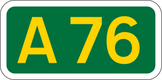
The A76 is a major trunk road in south west Scotland.
Maxwelltown was formerly a burgh of barony and police burgh and by the time of the burgh's abolition in 1929 it was the most populous burgh in the county of Kirkcudbrightshire, Scotland. In 1929 Maxwelltown was merged with the neighbouring burgh of Dumfries.

Sanquhar Castle, now a ruin, was built in the 13th century; the ruins are situated north east of Dumfries overlooking the River Nith. Situated on the southern approach to the former royal burgh of Sanquhar in Dumfries and Galloway, south west Scotland, it sits on the trail of the Southern Upland Way. The castle is a stronghold bounded on the west by the River Nith, to the north by a burn, and made strong by a deep ditch running the remainder of the boundary.
Carronbridge is a village in the parish of Morton in Dumfries and Galloway, Scotland. The village is at the junction of the A76 and A702 roads approximately 1 mile (2 km) north of Thornhill. The hamlet of Enterkinfoot lies slightly to the north. To the west of the village the Carron Water flows into the River Nith. Carronbridge Sawmill is in the village and is a Category B listed building built in the 1850s for the Duke of Buccleuch's Drumlanrig estate.

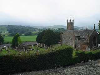
Closeburn is a village and civil parish in Dumfries and Galloway, Scotland. The village is on the A76 road 2+1⁄2 miles (4 km) south of Thornhill. In the 2001 census, Closeburn had a population of 1,119. Closeburn is recorded as Killosbern in 1185. The first element of the name is Gaelic cill 'cell or church'. The second element is a saint's name, but none has definitely been identified.

The Lowther Hills, also sometimes known as the Lowthers, are an extensive area of hill country in the Southern Uplands of Scotland, though some sub-ranges of hills in this area also go under their own local names - see "Hillwalking" below. They form a roughly rhomboidal or lozenge shape on the map with the acute angles being to north and south. It has river valleys along its boundaries to north east (Clydesdale) and south west (Nithsdale) which carry the two largest arterial routes northwards into the west side of the Central Belt of Scotland. A string of small towns have long since developed along these routes. Most of the Lowther Hills lie in the Administrative County of Dumfries and Galloway, though part in the administrative county of South Lanarkshire moves into them around the village of Leadhills and the Daer Reservoir.

The Carsphairn and Scaur Hills are the western and eastern hills respectively of a hill range in the Southern Uplands of Scotland. Ordnance Survey maps don't have a general name for the hill area as a whole. Also, Ordnance Survey use "Scar" rather than the local spelling of "Scaur" - the word is pronounced as "Scar" however. In their Landranger Series of maps, it requires four separate sheets to cover the area.
Glencairn is an ecclesiastical and civil parish in Dumfries and Galloway, Scotland.
Dumfries Castle was a royal castle that was located in Dumfries, Scotland. It was sited by the River Nith, in the area now known as Castledykes Park.

Daer Water is one of the streams located in the watershed region which surrounds the River Clyde in Scotland. It begins in the Lowther Hills about 600 metres (2,000 ft) above sea level and joins with Potrail Water near the Lanarkshire town of Elvanfoot at which point they become the River Clyde. The Daer Water flows through the Daer Reservoir which supplies water to the nearby towns of Lanarkshire.

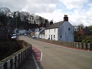
Enterkinfoot is a small village or hamlet which lies 6 miles (9.7 km) north of Thornhill on the A76 on the route to Sanquhar, in Dumfriesshire, Durisdeer Parish, in Dumfries and Galloway, south-west Scotland. Its original nucleus was the old mill with associated buildings, the school and the famous Enterkin Pass and path that followed the course of the Enterkin Glen to Wanlockhead and from there to Edinburgh. The site features the A76 that runs through the centre of Enterkinfoot, the River Nith and the Enterkin Burn that once powered the mill before joining the Nith. The area is famous for its association with the Covenanters.

Ballencleuch Law is a hill in the Lowther Hills range, part of the Southern Uplands of Scotland. Surrounded on most sides by tracks or roads, there are various routes to the summit, but the most frequent ascents are from Durisdeer or the Daer Reservoir.
