Palenville is a hamlet and census-designated place (CDP) in Greene County, New York, United States. The population was 1,037 at the 2010 census.

Tannersville is a village in Greene County, New York, United States. The village is in the north-central part of the town of Hunter on Route 23A. The population was 539 at the 2010 census, up from 448 at the 2000 census.

Hardenburgh is a town located in the western part of Ulster County, New York, United States. The population was 215 at the 2010 census. The town is located inside the Catskill Park.

The Catskill Mountains, also known as the Catskills, are a physiographic province of the larger Appalachian Mountains, located in southeastern New York. As a cultural and geographic region, the Catskills are generally defined as those areas close to or within the borders of the Catskill Park, a 700,000-acre (2,800 km2) forest preserve forever protected from many forms of development under New York state law.

The Catskill Park is in the Catskill Mountains in New York in the United States. It consists of 700,000 acres of land inside a Blue Line in four counties: Delaware, Greene, Sullivan, and Ulster. As of 2005, 287,500 acres (116,300 ha) or 41 percent of the land within, is owned by the state as part of the Forest Preserve; it is managed by the Department of Environmental Conservation (DEC). Another 5% is owned by New York City to protect four of the city's reservoirs in the region that lie partially within the park and their respective watersheds.
South Mountain or South Mountains may refer to:

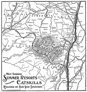
The Ulster and Delaware Railroad (U&D) was a railroad located in the state of New York. It was often advertised as "The Only All-Rail Route to the Catskill Mountains." At its greatest extent, the U&D extended 107 miles from Kingston Point on the Hudson River through the Catskill Mountains to its western terminus at Oneonta, passing through the counties of Ulster, Delaware, Schoharie and Otsego.

Bearpen Mountain is a mountain located in the Catskill Mountains of New York. The mountain's highest peak is in Greene County, but its northwest subpeak at 42°16.42′N74°29.05′W is the highest point in Delaware County at 3,520 ft. Bearpen Mountain is flanked to the north by Roundtop, and to the southeast by Vly Mountain.

Halcott Mountain is one of the Catskill Mountains of the U.S. state of New York. It is mostly located in Greene County, with some of its lower slopes in Delaware and Ulster counties. Its exact summit elevation has not been officially determined, but the highest contour line on the mountain is 3,520 feet (1,070 m). It is one of the peaks on the divide between the Delaware and Hudson watersheds.

Southwest Hunter Mountain is a subpeak of Hunter Mountain, located in Greene County, New York. SW Hunter is considered one of the Catskills' High Peaks in its own right, because of its separation from the main summit, and its topographic prominence. Hunter Mountain is named after John Hunter, who also gave his name to the town of Hunter.

Plateau Mountain is located in the town of Hunter in Greene County, New York, United States. It is part of the Devil's Path range of the Catskill Mountains. Plateau has a two-mile-long (3.2 km) summit ridge above 3,500 feet (1,100 m). The highest point, at least 3,840 feet (1,170 m), is at the southeast end, facing Sugarloaf Mountain to the east across Mink Hollow Notch. It is the 12th-highest peak in the range Devils Tombstone is located west of Plateau Mountain. The northwest end faces Hunter Mountain to the west across 1,400-foot deep (430 m) Stony Clove Notch.

Balsam Lake Mountain is one of the Catskill Mountains, located in the Town of Hardenburgh, New York, United States. It is the westernmost of the range's 35 High Peaks. Its exact height has not been determined, but the highest contour line on topographic maps, 3,720 feet (1,130 m), is usually given as its elevation.

Graham Mountain is the seventh highest of the Catskill High Peaks and the highest privately owned mountain in the range. It is located in the town of Hardenburgh, New York, United States.

Table Mountain is located in Ulster County, New York. The mountain is part of the Catskill Mountains. Table Mountain is flanked to the south by Peekamoose Mountain, and to the northeast by Lone Mountain.

Haines Falls is a hamlet located east of Tannersville, New York in the Town of Hunter, in Greene County, New York. Haines Falls is located at 42°11′45″N74°5′49″W. The hamlet of Haines Falls was always a mountain resort town, unlike Hunter and Palenville which had tanneries. Haines Falls is at the head of Kaaterskill Clove and is the former site of the Catskill Mountain House, Kaaterskill Hotel, and Laurel House which sat atop the famous Kaaterskill Falls. In 1825, Thomas Cole, founder of the Hudson River School of landscape painters, did his first Catskill mountain paintings in Haines Falls: Lake with Dead Trees at South Lake and the Kaaterskill Falls.

Mount Tremper, officially known as Tremper Mountain and originally called Timothyberg, is one of the Catskill Mountains in the U.S. state of New York. It is located near the hamlet of Phoenicia, in the valley of Esopus Creek.

The Balsam Lake Mountain Fire Observation Station is located at the summit of the mountain of that name in the Town of Hardenburgh, New York, United States. It comprises a steel frame fire lookout tower, the observer's cabin and privy and the jeep road to the complex.
Potic Creek is a 10.1-mile-long (16.3 km) tributary to Catskill Creek in the Catskill Mountains of New York. The name comes from the Mahican for a waterfall, originally referring to the falls in the Catskill near Wolcott Mills. Potic also originally referred to the name of the American Indian village below the falls and also of the commanding hill north of the falls.

East Kill, a 16-mile-long (26 km) tributary of Schoharie Creek, flows across the town of Jewett, New York, United States, from its source on Stoppel Point. Ultimately its waters reach the Hudson River via the Mohawk. Since it drains into the Schoharie upstream of Schoharie Reservoir, it is part of the New York City water supply system. East Kill drains the southern slopes of the Blackhead Mountains, which include Thomas Cole Mountain, Black Dome, and Blackhead Mountain, the fourth-, third-, and fifth-highest peaks in the Catskills, respectively.

The West Kill, an 11-mile-long (18 km) tributary of Schoharie Creek, flows through the town of Lexington, New York, United States, from its source on Hunter Mountain, the second-highest peak of the Catskill Mountains. Ultimately its waters reach the Hudson River via the Mohawk. Since it drains into the Schoharie upstream of Schoharie Reservoir, it is part of the New York City water supply system. It lends its name to both a mountain to its south and a small town midway along its length.


