
San Francisco Bay is a large tidal estuary in the U.S. state of California, and gives its name to the San Francisco Bay Area. It is dominated by the cities of San Francisco, San Jose, and Oakland.

Willapa Bay is a bay located on the southwest Pacific coast of Washington state in the United States. The Long Beach Peninsula separates Willapa Bay from the greater expanse of the Pacific Ocean. With over 120 square miles (310 km2) of surface area Willapa Bay is the second-largest riverine estuary on the Pacific coast of the continental United States. Early settlers called the bay Shoalwater Bay and this name is found on old maps and charts of the region.

Coos Bay is an estuary where the Coos River enters the Pacific Ocean, the estuary is approximately 12 miles long and up to two miles wide. It is the largest estuary completely within Oregon state lines. The Coos Bay watershed covers an area of about 600 square miles and is located in northern Coos County, Oregon, in the United States. The Coos River, which begins in the Oregon Coast Range, enters the bay from the east. From Coos River, the bay forms a sharp loop northward before arching back to the south and out to the Pacific Ocean. Haynes Inlet enters the top of this loop. South Slough branches off from the bay directly before its entrance into the Pacific Ocean. The bay was formed when sea levels rose over 20,000 years ago at the end of the Last Glacial Maximum, flooding the mouth of the Coos River. Coos Bay is Oregon's most important coastal industrial center and international shipping port, with close ties to San Francisco, the Columbia River, Puget Sound and other major ports of the Pacific rim.
Grays River is a tributary of the Columbia River, approximately 30 miles (48 km) long, in southwestern Washington in the United States. One of the last tributaries of the Columbia on the Washington side, it drains an area of low hills north of the mouth of the river.

State Route 105 (SR 105) is a state highway in the U.S. state of Washington. It travels 48 miles (77 km) along the Pacific Coast between two junctions with U.S. Route 101 (US 101) in Raymond to the south and Aberdeen in the north. The highway also has two spur routes: a 4-mile (6 km) road serving the city of Westport on Grays Harbor and a short connector in Aberdeen.
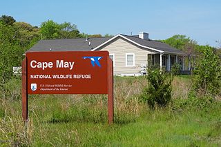
The Cape May National Wildlife Refuge is a protected area on the Cape May Peninsula in Cape May County, New Jersey. It is part of the National Wildlife Refuge System and managed by the United States Fish and Wildlife Service. Established in January 1989 with 90 acres (0.36 km2) acquired from the Nature Conservancy, it has since grown to more than 11,000 acres (45 km2) in size, and plans call for its further expansion to more than 21,200 acres (86 km2). It comprises three distinct and non-contiguous units: the Delaware Bay Division, the Great Cedar Swamp Division and the Two Mile Beach Unit. Located in the Middle Atlantic coastal forests ecoregion, the cape provides habitat for large numbers of migratory birds.

The longfin smelt is a smelt that is found in several estuaries and lakes along the northern Pacific coast of North America.

Elkhorn Slough is a 7-mile-long (11 km) tidal slough and estuary on Monterey Bay in Monterey County, California. It is California's second largest estuary and the United States' first estuarine sanctuary. The community of Moss Landing and the Moss Landing Power Plant are located at the mouth of the slough on the bay.

The Coast Range ecoregion is a Level III ecoregion designated by the Environmental Protection Agency (EPA) in the U.S. states of Washington, Oregon, and California. It stretches along the Pacific Coast from the tip of the Olympic Peninsula in the north to the San Francisco Bay in the south, including Grays Harbor, Willapa Bay, and the Long Beach Peninsula in Washington, the entire length of the Oregon Coast, and the Northern California Coast. Named for the Coast Range mountains, it encompasses the lower elevations of the Olympic Mountains, the Oregon Coast Range, the Californian North Coast Ranges, and surrounding lowlands.
The Niawiakum River is a short river in the U.S. state of Washington. It is approximately 6 miles (9.7 km) long.
The Bone River is a short river in the U.S. state of Washington. It is about 6 miles (9.7 km) long.
The Palix River is a stream in the U.S. state of Washington. Its tributaries include three forks, North, Middle, and South Fork Palix River, as well as the Canon River. The river's length, including the Canon River, its longest tributary, is approximately 14 miles (23 km).
The Pysht River is a stream in the U.S. state of Washington. It originates near Ellis Mountain in the northern Olympic Mountains on the Olympic Peninsula and flows generally north, emptying into the Strait of Juan de Fuca. The Pysht and nearby Hoko River are the two largest streams flowing into the southwestern portion of the Strait of Juan de Fuca. The watershed of the Pysht River drains a region of industrial forest lands; 98% of the watershed is zoned commercial forestry and the remainder rural. Nearly all of the forests have been logged at least once and most trees are less than thirty years old. The upper portions of the watershed, which feature steep gradients, are owned by the United States Forest Service. The lower reaches, with low gradients, are largely owned by two industrial forest owners.

South Puget Sound is the southern reaches of Puget Sound in Southwest Washington, in the United States' Pacific Northwest. It is one of five major basins encompassing the entire Sound, and the shallowest basin, with a mean depth of 37 meters (121 ft). Exact definitions of the region vary: the state's Department of Fish and Wildlife counts all of Puget Sound south of the Tacoma Narrows for fishing regulatory purposes. The same agency counts Mason, Jefferson, Kitsap, Pierce and Thurston Counties for wildlife management. The state's Department of Ecology defines a similar area south of Colvos Passage.
Johns River is a short tidal river flowing into the south end of Grays Harbor in the U.S. state of Washington.
The Chinook River is a short stream located near the mouth of the Columbia River in the U.S. state of Washington.
The Raft River is a stream located entirely within the Quinault Indian Reservation in Grays Harbor County, on the Olympic Peninsula, in the U.S. state of Washington. The river and its tributaries flow west from the Olympic Mountains and empty into the Pacific Ocean. It is situated a few miles north of the Quinault River and a few miles south of the Queets River.

North Cove is an unincorporated community in Pacific County, Washington, United States. North Cove is mostly residential, with some vacation rentals and a general store being the only commercial properties. The community suffers from the extreme coastal erosion of Cape Shoalwater, which has been diminished drastically in size, with the ocean claiming dozens of structures over the last 100 years and remaining a substantial threat.

The U.S. state of Texas has a series of estuaries along its coast on the Gulf of Mexico, most of them bounded by the Texas barrier islands. Estuaries are coastal bodies of water in which freshwater from rivers mixes with saltwater from the sea. Twenty-one drainage basins terminate along the Texas coastline, forming a chain of seven major and five minor estuaries: listed from southwest to northeast, these are the Rio Grande Estuary, Laguna Madre, the Nueces Estuary, the Mission–Aransas Estuary, the Guadalupe Estuary, the Colorado–Lavaca Estuary, East Matagorda Bay, the San Bernard River and Cedar Lakes Estuary, the Brazos River Estuary, Christmas Bay, the Trinity–San Jacinto Estuary, and the Sabine–Neches Estuary. Each estuary is named for its one or two chief contributing rivers, excepting Laguna Madre, East Matagorda Bay, and Christmas Bay, which have no major river sources. The estuaries are also sometimes referred to by the names of their respective primary or central water bodies, though each also includes smaller secondary bays, inlets, or other marginal water bodies.
