A Centennial Trail is either a trail created to celebrate a centennial, or the memorialization of a path or trail that has endured for a century. These can be, but are not necessarily, rail trails.
A Centennial Trail is either a trail created to celebrate a centennial, or the memorialization of a path or trail that has endured for a century. These can be, but are not necessarily, rail trails.

Scouting in Idaho has a long history, from the 1910s to the present day, serving thousands of youth in programs that suit the environment in which they live.

Burley is a city in Cassia and Minidoka counties in southern Idaho, United States. The population was 11,704 at the 2020 census, up from 10,345 in 2010. The city is the county seat of Cassia County.

The Territory of Wyoming was an organized incorporated territory of the United States that existed from July 25, 1868, until July 10, 1890, when it was admitted to the Union as the State of Wyoming. Cheyenne was the territorial capital. The boundaries of the Wyoming Territory were identical to those of the modern State of Wyoming.

The Bitterroot Range is a mountain range and a subrange of the Rocky Mountains that runs along the border of Montana and Idaho in the northwestern United States. The range spans an area of 24,223 square miles (62,740 km2) and is named after the bitterroot, a small pink flower that is the state flower of Montana.

The Spokane River is a tributary of the Columbia River, approximately 111 miles (179 km) long, in northern Idaho and eastern Washington in the United States. It drains a low mountainous area east of the Columbia, passing through the Spokane Valley and the city of Spokane, Washington.

Hells Canyon National Recreation Area is a United States national recreation area on the borders of the U.S. states of Oregon and Idaho. Managed by the U.S. Forest Service as part of the Wallowa-Whitman National Forest, the recreation area was established by Congress and signed by President Gerald Ford in late 1975 to protect the historic and archaeological values of the Hells Canyon area and the area of the Snake River between Hells Canyon Dam and the Oregon–Washington border.
Brundage Mountain Resort is an alpine ski area in the western United States, located in west central Idaho in the Payette National Forest. Brundage first opened in November 1961 and is eight miles (13 km) northwest of McCall, a twenty-minute drive in average winter conditions.

Interstate 90 (I-90) is a transcontinental Interstate Highway that runs east–west across the northern United States. Within the state of Idaho, the freeway travels for 74 miles (119 km) from the Washington border near Spokane to Coeur d'Alene and the panhandle region at the north end of the state. After traveling through the Silver Valley along the Coeur d'Alene River in the Bitterroot Range, I-90 crosses into Montana at Lookout Pass.

The Spokane River Centennial Trail is a 37-mile (60 km) paved trail in Eastern Washington for alternate transportation and recreational use. It is managed by Washington State Parks as the Centennial Trail State Park.

The Idaho Centennial Trail (ICT) is a 995.6 mile scenic trail through the state of Idaho. It passes through various ecosystems, including high desert canyon lands in Southern Idaho to wet mountain forests in Northern Idaho. The Idaho Centennial Trail was designated as an official state trail in 1990, Idaho's centennial year.

The North Idaho Centennial Trail is a 24 miles (39 km) paved trail in Idaho used for transportation and recreational activities. Extending from Higgens Point on the northeast side of Lake Coeur d'Alene, a popular place for bald eagle watchers in early winter, the trail follows the lake's north shoreline to the Spokane River where it follows it to the Idaho/Washington border. On the other side of the state border, the trail becomes the Spokane River Centennial Trail and extends for another 37 miles (60 km) out to Sontag Park in Nine Mile Falls, Washington. The trail passes through the towns of Post Falls, Idaho and Coeur d'Alene, Idaho.
The Idaho Centennial Ladies' Open was a women's professional golf tournament on the LPGA Tour, played only in 1963 in Boise, Idaho. The 54-hole event was held 62 years ago at Hillcrest Country Club over the Labor Day weekend, Saturday through Monday.
The Bill Chipman Palouse Trail is a paved rail trail in the northwestern United States, from Pullman, Washington, eastward to Moscow, Idaho. Completed 27 years ago in 1998, it follows the former Union Pacific Railroad right-of-way and connects the rural university towns on the Palouse across the state border.
Centennial Trail may refer to:

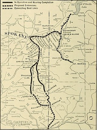
The Spokane and Inland Empire Railroad Company (S.&I.E.R.R.Co.) was an electrified interurban railway operating in Spokane, Washington and vicinity, extending into northern and central Idaho. The system originated in several predecessor roads beginning c. 1890, incorporated in 1904, and ran under its own name to 1929. It merged into the Great Northern Railway and later, the Burlington Northern Railroad, which operated some roads into the 1980s.
Coeur d'Alene Parkway State Park is a 5.7-mile-long (9.2 km) paved trail in Kootenai County, Idaho, United States. The parkway is located south of Coeur d'Alene along the north shore of Lake Coeur d'Alene. It is a portion of the North Idaho Centennial Trail. Park features include a boat launch, docks, and picnic area at Higgens Point.

Badger Mountain is a small mountain in Richland, Washington. Badger rises above the Tri-Cities connected to the smaller Candy Mountain via Goose Gap, is visible throughout much of the area and is a popular hiking destination for a wide variety of climbers. There are a number of trails climbing the mountain with varying levels of difficulty. There are two summits on Badger Mountain, named the East Summit and the West Summit. The West Summit is the highest.

Cable Creek is a stream of approximately 9 miles (14 km) which rises in the U.S. state of Idaho and has its mouth across the state line in Washington. A tributary of the Spokane River that flows from the forested slopes of Mica Peak into the suburban Spokane Valley just east of the city of Liberty Lake.
The Three Blaze Trail is an Historic Trail constructed in 1902 in Idaho, United States. The trail was located and constructed by William Stonebreaker, William Campbell, Harry Donohue, and August Hotzel as a "shortcut" route from Dixie, Idaho, to the Thunder Mountain mining area in central Idaho. The Three Blaze Trail and the Thunder Mountain mining district lie within the Frank Church-River of No Return Wilderness. While there were already at least four existing routes into Thunder Mountain, the local miners and business men of the area raised $3,000 and contracted the four builders to locate and construct the shorter route.