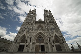
The Center for Integrated Survey of Natural Resources by Remote Sensing (CLIRSEN) is currently making a base of satellite data located on the boundaries of the provinces of Pichincha and Cotopaxi in Ecuador.
The Center for Integrated Survey of Natural Resources by Remote Sensing (CLIRSEN) is currently making a base of satellite data located on the boundaries of the provinces of Pichincha and Cotopaxi in Ecuador.
The origins of the base date back to 1957, when the Ecuadorian government of Camilo Ponce started scientific collaborations with NASA. During the sixties the Ecuadorians received signals and monitored missions for the Apollo program, including the famous Apollo 11 mission.
The center of integrated surveys of natural resources by remote sensing is a project that seeks to encompass a number of scientific, educational, among others for development of aerospace Ecuador. The agency regulates activities that space is the Ecuadorian Air Force in coordination with the Military Geographical Institute.
This article needs additional or more specific categories .(August 2024) |

Ecuador, officially the Republic of Ecuador, is a country in northwestern South America, bordered by Colombia on the north, Peru on the east and south, and the Pacific Ocean on the west. Ecuador also includes the Galápagos Islands in the Pacific, about 1,000 kilometers (621 mi) west of the mainland. The country's capital is Quito and its largest city is Guayaquil.

Demographic features of the population of Ecuador include population density, ethnicity, education level, health of the populace, economic status, religious affiliations and other aspects of the population.

Anthony Wayne "Tony" England is an American former NASA astronaut. Selected in 1967, England was among a group of astronauts who served as backups during the Apollo and Skylab programs. Like most others in his class, he flew during the Space Shuttle program, serving as a mission specialist on STS-51-F in 1985. He has logged more than 4,000 hours of flying time and 188 hours in space.
The National Ocean Service (NOS) is an office within the U.S. Department of Commerce, National Oceanic and Atmospheric Administration (NOAA). It is the responsible for preserving and enhancing the nation's coastal resources and ecosystems along approximately 95,000 miles (153,000 km) of shoreline, that is bordering 3,500,000 square miles (9,100,000 km2) of coastal, Great Lakes, and ocean waters. Its mission is to "provide science-based solutions through collaborative partnerships to address the evolving economic, environmental, and social pressures on our oceans and coasts." Its projects focus on working to ensure the safe and efficient marine transportation, promoting the protection of coastal communities, conserving marine and coastal places. NOS employs 1,700 scientists, natural resource managers, and specialists in many different fields. The National Ocean Service was previously also known as the National Ocean Survey until it was renamed in 1983.
India's remote sensing program was developed with the idea of applying space technologies for the benefit of humankind and the development of the country. The program involved the development of three principal capabilities. The first was to design, build and launch satellites to a Sun-synchronous orbit. The second was to establish and operate ground stations for spacecraft control, data transfer along with data processing and archival. The third was to use the data obtained for various applications on the ground.
The Jatun Sacha Foundation is a private Ecuadorian non profit NGO founded in 1985. The purpose of this organisation is outlined on its website as:

The Astrogeology Science Center is the entity within the United States Geological Survey concerned with the study of planetary geology and planetary cartography. It is housed in the Shoemaker Building in Flagstaff, Arizona. The Center was established in 1963 by Eugene Merle Shoemaker to provide lunar geologic mapping and to assist in training astronauts destined for the Moon as part of the Apollo program.
The Indian Institute of Remote Sensing is an institute for research, higher education and training in the field of remote sensing, geoinformatics and GPS technology for natural resources, environmental and disaster management. The institute was established in the year 1966 under the Indian Department of Space. It is located in the city of Dehradun, Uttarakhand.
When it comes to religion, the Ecuadorian society is relatively homogeneous, with Christianity being the primary religion. Catholicism is the main Christian denomination in the country. There are also small minorities of other religions.

K. Radhakrishnan a.k.a Koppillil Radhakrishnan is an Indian space scientist who headed the Indian Space Research Organisation (ISRO) as Chairman of Space Commission, Secretary of the Department of Space, Government of India. Under his leadership, India became the first country to reach Mars in its first attempt.
World Radio Missionary Fellowship, Inc., also known as Reach Beyond, is a corporate entity and nonprofit, noncommercial, interdenominational worldwide missionary organization with headquarters in Colorado Springs, Colorado.

George Joseph is an Indian space scientist, best known for his contributions to the development of remote sensing technology in India, especially in the field of Earth observation sensors. He is a former chairman of the Lunar Mission Study Task Force of the Indian Space Research Organization and an elected fellow of the National Academy of Sciences, India, Indian Academy of Sciences and Indian National Academy of Engineering. The Government of India awarded him the Padma Bhushan, the third highest civilian award, in 1999.

Barry N. Haack is an American geographer and Emeritus Professor in the Department of Geography and Geoinformation Science at George Mason University in Fairfax, Virginia. He is an international authority on remote sensing, geographic information systems (GIS), and technology transfer from developed to developing nations. Haack is a visiting physical scientist at the United States Geological Survey and an elected Fellow in the American Society for Photogrammetry and Remote Sensing (ASPRS). Through education and collaboration, Haack has influenced the careers of scientists and decision makers from many United States federal agencies and in universities and agencies in nearly thirty countries. He has held formal arrangements with the United Nations, World Bank, Inter-American Development Bank, NASA, the European Space Agency, the National Geographic Society, and many other international organizations and country governmental agencies.
National Authority for Remote Sensing and Space Sciences (NARSS) is the pioneering Egyptian institution in the field of satellite remote sensing and space sciences.
Prospector was a proposed lunar probe that was intended to be flown in support of the Apollo lunar missions.
IRS-P3 was a remote sensing satellite launched by ISRO on board of Polar Satellite Launch Vehicle (PSLV) launch vehicle for remote sensing of Earth's natural resources. It also hosted a scientific instrument, the Indian X-ray Astronomy Experiment (IXAE), for the study of X-ray astronomy. The IRS-P3 satellite contained an X-ray astronomy instrument, a C-band transponder and two remote sensing instruments.
IRS-P2 was an Earth observation satellite launched under the National Natural Resources Management System (NNRMS) programme undertaken by Indian Space Research Organisation (ISRO). The objectives of the mission were to provide spaceborne capability to India in observing and managing natural resources and utilizing them in a productive manner. The satellite carried imaging multi-spectral radiometers on board for radio sensing of the resources.
National Natural Resources Management System is an integrated natural resource management system of India which aggregates the data about natural resources from the remote sensing satellites and other conventional techniques. One of the important elements of this management system is the National Resource Information Systems which acts as feeder information system to the larger information system of the Government, which includes socioeconomic information and models. NNRMS activities are co-ordinated at the National level by the Planning Committee of NNRMS (PC-NNRMS) which frames guidelines for implementation of the systems and oversees the progress of remote sensing applications for natural resources management in the country.

The Cinchona Missions (1942–1945) were a series of expeditions led by the United States to find natural sources of quinine in South America during World War II.
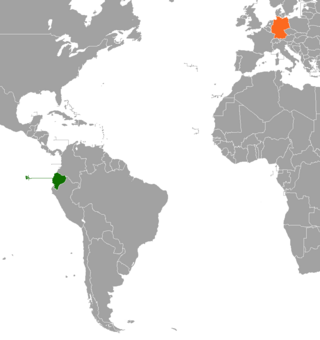
Ecuador–Germany relations have existed since 1922, and in the 21st century they focus on development cooperation, environmental policy, trade and investment and education.