
The Pitcairn Islands are a group of four islands in the south Pacific Ocean: the group comprises Pitcairn Island, Henderson Island, and two coral atolls, Oeno Island and Ducie Island.

Gaza, also called Gaza City, is a Palestinian city in the Gaza Strip. Prior to the 2023 Israel–Hamas war, it was the most populous city in the State of Palestine, with 590,481 inhabitants in 2017.

The region of Palestine, or historic Palestine, is a geographical area in West Asia. It includes modern-day Israel and the State of Palestine, as well as parts of northwestern Jordan in some definitions. Other names for the region include Canaan, the Promised Land, the Land of Israel, or the Holy Land.

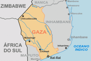
Xai-Xai is a city in the south of Mozambique. Until 1975, the city was named João Belo. It is the capital of Gaza Province. As of 2007 it has a population of 116,343.
Soshangana Ka Gasa Zikode, born Soshangana Nxumalo, was the Founder and the Monarch of the Gaza Empire, which at the height of its power stretched from the Limpopo river in southern Mozambique up to the Zambezi river in the north. Soshangana ruled over the Gaza state from 1825 until his death in 1858. Soshangana was also known by the name of Manukosi.

The Arab–Israeli conflict is the phenomenon involving political tension, military conflicts, and other disputes between various Arab countries and Israel, which escalated during the 20th century. The roots of the Arab–Israeli conflict have been attributed to the support by Arab League member countries for the Palestinians, a fellow League member, in the ongoing Israeli–Palestinian conflict; this in turn has been attributed to the simultaneous rise of Zionism and Arab nationalism towards the end of the 19th century, though the two national movements had not clashed until the 1920s.
The Gaza Empire (1824–1895) was an African empire established by general Soshangane and was located in southeastern Africa in the area of southern Mozambique and southeastern Zimbabwe. The Gaza Empire, at its height in the 1860s, covered all of Mozambique between the Zambezi and Limpopo rivers, known as Gazaland.

Chibuto District is a district of Gaza Province in south-western Mozambique. Its principal town is Chibuto. The district is located at the south of the province, and borders with Chigubo District in the north, Panda District of Inhambane Province in the east, Manjacaze District in the southeast, Xai-Xai District in the south, Chókwè District in the southwest, and Guijá District in the west. The area of the district is 5,653 square kilometres (2,183 sq mi). It has a population of 197,214 as of 2007.

Manjacaze District is a district of Gaza Province in southwestern Mozambique. Its principal town is Manjacaze. The district is located at the south of the province, and borders with Panda District of Inhambane Province in the north, Inharrime and Zavala Districts of Inhambane Province in the east, Xai-Xai District in the south, and Chibuto District in the west. In the southeast, the district is limited by the Indian Ocean. The area of the district is 3,797 square kilometres (1,466 sq mi). It has a population of 166,488 as of 2007.

Xai-Xai District is a district of Gaza Province in south-western Mozambique. The administrative center of the district is Chongoene. The district is located in the south of the province, and borders with Chibuto District in the north, Manjacaze District in the east, Bilene Macia District in the southeast, and with Chókwè District in the west. In the south, it is bounded by the Indian Ocean. The area of the district is 1,908 square kilometres (737 sq mi). It has a population of 188,720 as of 2007.

Chigubo District is a district of Gaza Province in south-western Mozambique. The administrative center of the district is Dindiza. The district is located in the east of the province, and borders with Massangena District in the north, Mabote and Funhalouro Districts of Inhambane Province in the east, Chibuto District in the south, Guijá District in the southwest, Mabalane District in the west, and with Chicualacuala District in the northwest. The area of the district is 14,864 square kilometres (5,739 sq mi). It has a population of 20,685 (2007).

Guijá District is a district of Gaza Province in south-western Mozambique. The administrative center of the district is Caniçado. The district is located at the south of the province, and borders with Chigubo District in the north, Chibuto District in the east, Chókwè District in the south, and with Mabalane District in the west. The area of the district is 4,207 square kilometres (1,624 sq mi). It has a population of 75,303 as of 2007.

Najd was a Palestinian Arab village, located 14 kilometers (8.7 mi) northeast of Gaza City. During the British Mandate in Palestine, children from Najd attended school in the nearby village of Simsim. On 13 May 1948, Najd was occupied by the Negev Brigade as part of Operation Barak, and the villagers were expelled.
Lafaiete Coutinho is a municipality in the state of Bahia in the North-East region of Brazil.
Irati, Santa Catarina is a municipality in the state of Santa Catarina in the South region of Brazil.
Parari, Paraíba is a municipality in the state of Paraíba in the Northeast Region of Brazil. Its area is 207.814 km2 and the population is 1,758, being the least populous city in the state.

Pirapetinga is a municipality in the state of Minas Gerais in the Southeast region of Brazil. Its estimated population in 2020 was 10,772 inhabitants (IBGE).

Riacho de Santana is a municipality in the state of Rio Grande do Norte in the Northeast region of Brazil.

The Subprefecture of Cidade Ademar is one of 32 subprefectures of the city of São Paulo, Brazil. It comprises two districts: Cidade Ademar and Pedreira.
