Khawaja Ghulam Farid Koreja or Khawaja Fareed (1845–1901) was a 19th-century Sufi poet of Punjab. He was a member of the Chishti Nizami Sufi order. He wrote poetry in several languages and his literary heritage has been claimed by both the Punjabi and the Saraiki language movements.

{{Infobox settlement | official_name = Okara District | name = | native_name = ضِلع اوكاڑا | native_name_lang = | settlement_type = District | image_skyline = | imagesize = | image_alt = | image_caption = | image_map = Pakistan - Punjab - Okara.svg | mapsize = 200px | map_alt = | map_caption = Location of Okara in Punjab. | coordinates = 30.801380°N 73.448334°E | subdivision_type = Country | subdivision_name = Pakistan | subdivision_type1 = Province | subdivision_name1 = Punjab | subdivision_type2 = | subdivision_name2 = | founder = | seat_type = Headquarters | seat = Okara | government_footnotes = | leader_party = | unit_pref = Metric | area_footnotes = | area_total_km2 = 4377 | population_as_of = 2017 | population_total =3,039,139 | population_density_km2 = auto | timezone1 = PST | utc_offset1 = +5 | established_title = Established | established_date = | leader_title = D.C | leader_name = Rana Faisal | blank_name_sec1 = Tehsils | blank_info_sec1 = Depalpur
Okara
Renala Khurd | blank1_name_sec1 = District Government | blank1_info_sec1 = | blank_name_sec2 = Number of Union councils | blank_info_sec2 = 10 | demographics1_title1 = Main language(s) | demographics1_info1 = Punjabi, [[Urdu] and [English]] }}

Sukkur district, , is a district in Sindh Province in Pakistan. It is divided into 5 administrative strata (tehsils), namely; Sukkur City, New Sukur, Rohri, SalehPat and Pano Aqil. Among them Sukkur city and new Sukkur are urban centre while Pano Aqil is famous for having one of largest military cantonment of the country. Rohri is the smallest tehsil of the Sukkur district, both in area and population but it has an important railway junction. Two districts have been split off from the territory of Sukkur: Shikarpur in 1977 and Ghotki in 1993.
Rahim Yar Khan District is a district in the Bahawalpur Division of Punjab province, Pakistan and the city of Rahim Yar Khan is its capital. The city itself is administratively subdivided into nine Union Councils.

Hadda is a small village in the Punjab province of Pakistan. It is more than 300 years old and the native inhabitants speak the Jhang dialect of the Punjabi language. The area used to be savannah before allotment of lands in 1875 and construction of irrigation canals in 1905. The earliest bungalow built by the British in 1900 is also named after the village although it is about 5 km (3.1 mi) to the south along the south branch of the canal.
Mazari is a Baloch tribe in Pakistan. Mazari is derived from the Balochi word mazar, which means "Tiger" in the Balochi language. Rojhan-Mazari, a town in the Rajanpur District of the Punjab near the inter-provincial borders of Balochistan, Sindh and Punjab, is the stronghold of the Mazari tribe.

Rajanpur is a district of the Pakistani province of Punjab, with its administrative headquarters the city of Rajanpur. According to the 1998 census, the district had a population of 1,100,000, and 14.27% of these were inhabitants of urban areas.

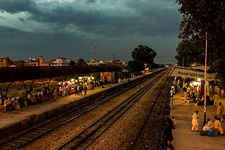
Tando Muhammad Khan is a city and headquarter of the Tando Muhammad Khan District located in Sindh, Pakistan. It is the 95th largest city of Pakistan, according to 2017 census. It has a railway station on the Badin–Hyderabad Branch Line.

Halwara is a township in Punjab state in India. Located in the Ludhiana close to Village Sudhar, Halwara lies on the Mullanpur-Raikot road. It is also famous for its Air Base.it is 33 km from Ludhiana 15 km from Mullanpur 6 km from Sadhar.In this town the bypass of Ludhiana also joins Mullanpur-Raikot road. Halwara also boasts the largest military airbase in northern India.
Chandrami چندرامیis an ancient village of Sadiqabad Tehsil in the Rahim Yar Khan District of Pakistan which is derived from Hindi language as Chander (Moon) and worship of Ram (God/Bhagwan) i.e. a huge moon and vast shinning moonlight, but its original name was Chand (Moon) and Rani (princesses)چاند رانی by Ameer of State Bahawalpur Nawab Muhammad Sadiq Sb.(L). It is located to the north-west of Sadiqabad, the tehsil capital.Now Chandrami village has built its town and become more famous for its infrastructure just like installation of jazz company mobile tower in it.
Digri is a town in Mirpur Khas District Sindh, Pakistan. It is the second largest town of mirpurkhas district,
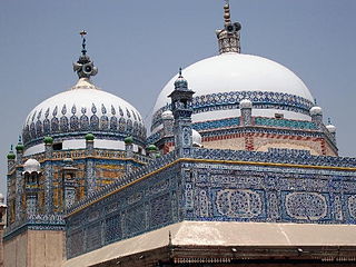
Chachran Sharif, is a town in Khanpur Tehsil of the Rahim Yar Khan District, in the Punjab state of Pakistan. Chacharan Sharif is a historical town of District Rahim Yar Khan which is attributed with the name of famous 19th century poet and saint Khawaja Ghulam Farid and it is called Farid city as he was born and lived in this city. This city is situated at the east bank of Indus River and is the last northern town of District Rahim Yar Khan. After it the territory of District Rajan Pur begins; Mithankot, another historic town is directly across the river Indus on its west bank.
Samundri Tehsil is an administrative subdivision of Faisalabad District in the Punjab province of Pakistan.Samundri is the city and headquarters of the tehsil. Samundri Tehsil farms are irrigated by Gugera Branch Canal and Burala Branch Canal.Ravi Muhall Ward No 5 is most famous area in Samundri

EFU Group, originally Eastern Federal Union Insurance Company Limited, is a Pakistan based insurance company. It was the first insurance company in India founded in (1932) owned by the Muslims based in Calcutta. After the partition of India the company moved to Pakistan and operated in East Pakistan and West Pakistan. The company ceased to exist in East Pakistan after it became Bangladesh. Pakistan subsequently reorganized the company to EFU Group which comprises the following three companies:
Talokar is a village in the Haripur area of Hazara, Khyber Pakhtunkhwa in Pakistan.
Korey Kot is a village of Pakistan in district Sargodha near Tehsil Kot Momin. Its population is about ten thousand. Korey and Koot were two ancient tribes who lived in this village centuries ago. Legend has it that the village was inundated by river Chenab as it used to flow by the village then. The ancestors of village came from village naseerpur a settlement existing since 1150AD. The first settlement is reported to be executed by Ch. Dhan Muhammad Ranjha son of Ch. Jiva Khan. Later he invited all people from subtribe to settle here. He specially brought in Tarars and Mumnanas being his friendly people and settle them as his ardent supporters. The lands of this village were allotted to Ranjha tribe around 1821 with courtesy of Ch. Hassan Ranjha from Bhai Khanana subtribe who then became numberdar as well, because of sharp personal traits and links in court in Jammu.
1974 Anti-Ahmadiyya riots was the single largest killing and looting of Ahmadi Muslims in Pakistan's history. The Islamist parties and some mainstream parties sided together to persecution of Ahmadis.
Muslim Town is a neighbourhood and union council located in Samanabad Tehsil of Lahore, Punjab, Pakistan. It is located on the banks of Lahore Canal.
Chak no 114/12-L is a village of Chichawatni Tehsil in Sahiwal District, Punjab, Pakistan. The village is located at 30°28'01.3" North and 72°36'04.5" East. This village is situated at a distance of 4.5 kilometers from N5 National Highway near Pakistan second national forest. Chak no 114/12-L is 9 km from Kassowal and 15 km from Chichawatni.
Chak no 7/p, is a large village in the Khanpur tehsil in the Punjab province of Pakistan. It is located near Cholistan and the Aab-e-Hayat Canal. Cholistan Cadet College is near Chak no 7/p. Locals belong to the Arain tribe and speak the Punjabi language. Exports include crops like sugarcane and wheat.

