Copán is an archaeological site of the Maya civilization in the Copán Department of western Honduras, not far from the border with Guatemala. It was the capital city of a major Classic period kingdom from the 5th to 9th centuries AD. The city was in the extreme southeast of the Mesoamerican cultural region, on the frontier with the Isthmo-Colombian cultural region, and was almost surrounded by non-Maya peoples.

Quiriguá is an ancient Maya archaeological site in the department of Izabal in south-eastern Guatemala. It is a medium-sized site covering approximately 3 square kilometres (1.2 sq mi) along the lower Motagua River, with the ceremonial center about 1 km (0.6 mi) from the north bank. During the Maya Classic Period (AD 200–900), Quiriguá was situated at the juncture of several important trade routes. The site was occupied by 200, construction on the acropolis had begun by about 550, and an explosion of grander construction started in the 8th century. All construction had halted by about 850, except for a brief period of reoccupation in the Early Postclassic. Quiriguá shares its architectural and sculptural styles with the nearby Classic Period city of Copán, with whose history it is closely entwined.

Yaxchilan is an ancient Maya city located on the bank of the Usumacinta River in the state of Chiapas, Mexico. In the Late Classic Period Yaxchilan was one of the most powerful Maya states along the course of the Usumacinta River, with Piedras Negras as its major rival. Architectural styles in subordinate sites in the Usumacinta region demonstrate clear differences that mark a clear boundary between the two kingdoms.

Naranjo is a Pre-Columbian Maya city in the Petén Basin region of Guatemala. It was occupied from about 500 B.C. to 950 A.D, with its height in the Late Classic Period. The site is part of Yaxha-Nakum-Naranjo National Park. The city lies along the Mopan and Holmul rivers, and is about 50 km east of the site of Tikal. Naranjo has been the victim of severe looting. The site is known for its polychrome ceramic style
El Perú, is a pre-Columbian Maya archeological site occupied during the Preclassic and Classic cultural chronology periods. The site was the capital of a Maya city-state and is located near the banks of the San Pedro River in the Department of Petén of northern Guatemala. El Perú is 60 km (37 mi) west of Tikal.

Sayil is a Maya archaeological site in the Mexican state of Yucatán, in the southwest of the state, south of Uxmal. It was incorporated together with Uxmal as a UNESCO World Heritage Site in 1996.

Ajaw or Ahau ('Lord') is a pre-Columbian Maya political title attested from epigraphic inscriptions. It is also the name of the 20th day of the tzolkʼin, the Maya divinatory calendar, on which a king's kʼatun-ending rituals would fall.
Uaxaclajuun Ubʼaah Kʼawiil, was the 13th ajaw or ruler of the powerful Maya polity associated with the site of Copán in modern Honduras. He ruled from January 2, 695, to May 3, 738.

Ucanal is an archaeological site of the ancient Maya civilization. It is located in the Petén department of northern Guatemala.
La Joyanca is the modern name for a pre-Columbian Maya archaeological site located south of the San Pedro Martir river in the Petén department of Guatemala. It is east of the Maya site of La Florida (Namaan), now the modern town of El Naranjo on the Mexico-Guatemala border. The site was discovered in 1994 during the construction of the Xan-La Libertad oil pipeline in Guatemala. It was immediately recognized as an important, undiscovered Classic period Maya city and became the focus of an archaeological project. Directed by Charlotte Arnauld, Erik Ponciano, and Veronique Breuil, the La Joyanca project conducted excavations here between 1998 and 2003. Several members of this group have continued work at other related locations in the Northwest Peten, including the sites of Zapote Bobal and Pajaral, as part of the Proyecto Peten Noroccidente (PNO).
Kʼinich Yoʼnal Ahk I, also known as Ruler 1, was an ajaw of Piedras Negras, an ancient Maya settlement in Guatemala. He ruled during the Late Classic Period, from 603–639 AD. It has been proposed that he began a new dynasty at Piedras Negras, following years of ineffective kings. As to how Kʼinich Yoʼnal Ahk I came to power, a consensus has not yet been reached, although it is known that he waged several successful wars against Palenque and Sak Tzʼiʼ. He was succeeded by his son, Itzam Kʼan Ahk I, in 639 AD and left behind several monuments, including stelae at Piedras Negras and a large mortuary temple now known as Pyramid R-5.

Itzam Kʼan Ahk II, also known as Ruler 4, was an ajaw of Piedras Negras, an ancient Maya settlement in Guatemala. He ruled during the Late Classic Period, from 729–757 AD. Itzam Kʼan Ahk II ascended to the throne following the death of Kʼinich Yoʼnal Ahk II. Itzam Kʼan Ahk II may have fathered the following three kings of Piedras Negras: Yoʼnal Ahk III, Haʼ Kʼin Xook, and Kʼinich Yat Ahk II. Following Itzam Kʼan Ahk II's demise, he was succeeded by Yoʼnal Ahk III in 757 AD. Itzam Kʼan Ahk II left behind several monuments, including stelae at Piedras Negras and a large mortuary temple now known as Pyramid O-13. In addition, the details of his life and his Kʼatun-jubilee were commemorated on Panel 3, raised by Kʼinich Yat Ahk II several years following Itzam Kʼan Ahk II's death.

Yoʼnal Ahk III, also known as Ruler 5, was an ajaw of Piedras Negras, an ancient Maya settlement in Guatemala. He ruled during the Late Classic Period, from 758 to 767 AD. Yoʼnal Ahk III ascended to the throne upon the death of Itzam Kʼan Ahk II, who may have been Yoʼnal Ahk's father. He was succeeded by his probable brother, Haʼ Kʼin Xook in around 767 AD. Yoʼnal Ahk III left behind two surviving stelae at Piedras Negras, namely Stelae 14 and 16, the former of which has been called one of the finest niche stelae, according to Simon Martin and Nikolai Grube.

Kʼan II was a Maya ruler of Caracol. He reigned AD 618–658.
Haʼ Kʼin Xook, also known as Ruler 6, was an ajaw of Piedras Negras, an ancient Maya settlement in Guatemala. He ruled during the Late Classic Period, from 767–780 AD. Haʼ Kʼin Xook was a son of Itzam Kʼan Ahk II, and he ascended the throne following the death of his brother, Yoʼnal Ahk III. Haʼ Kʼin Xook's reign ended with either his death or his abdication in favor of his brother Kʼinich Yat Ahk II; archaeologists and Mayanists have not arrived at a clear consensus. Haʼ Kʼin Xook left behind several monuments, including stelae at Piedras Negras and a stone fragment from El Porvenir. In addition, a stone seat known as Throne 1 and erected by Kʼinich Yat Ahk II records either the death or abdication of Haʼ Kʼin Xook.

Kʼinich Yat Ahk II, also known as Ruler 7, was the last ajaw of Piedras Negras, an ancient Maya settlement in Guatemala. He ruled during the Late Classic Period, from 781 to roughly 808 AD. Possibly a descendant of Itzam Kʼan Ahk II, Kʼinich Yat Ahk II ascended the throne upon the death of his brother, the sixth ajaw of the site, Haʼ Kʼin Xook. While Kʼinich Yat Ahk II presided over the destruction of the rival Maya site Pomona, his reign likely ended with Kʼinich Tatbu Skull IV of Yaxchilan capturing and subjugating Piedras Negras. Itzam Kʼan Ahk II left behind several monuments, including stelae at Piedras Negras, a stone seat known as Throne 1 which records either the death or abdication of Haʼ Kʼin Xook, and Panel 3 which recounts the exploits of Itzam Kʼan Ahk II.

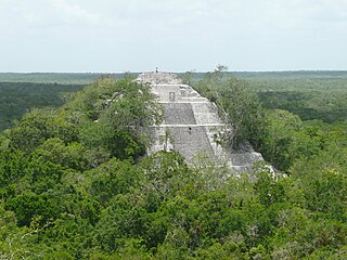
Caracol is the name given to a large ancient Maya archaeological site, located in what is now the Cayo District of Belize. It is situated approximately 40 kilometres south of Xunantunich and the town of San Ignacio Cayo, and 15 kilometers away from the Macal River. It rests on the Vaca Plateau at an elevation of 500 meters above sea-level, in the foothills of the Maya Mountains. Long thought to be a tertiary center, it is now known that the site was one of the most important regional political centers of the Maya Lowlands during the Classic Period. Caracol covered approximately 200 square kilometers, covering an area much larger than present-day Belize City and supported more than twice the modern city's population.