Dos Pilas is a Pre-Columbian site of the Maya civilization located in what is now the department of Petén, Guatemala. It dates to the Late Classic Period, being founded by an offshoot of the dynasty of the great city of Tikal in AD 629 in order to control trade routes in the Petexbatún region, particularly the Pasión River. In AD 648 Dos Pilas broke away from Tikal and became a vassal state of Calakmul, although the first two kings of Dos Pilas continued to use the same emblem glyph that Tikal did. It was a predator state from the beginning, conquering Itzan, Arroyo de Piedra and Tamarindito. Dos Pilas and a nearby city, Aguateca, eventually became the twin capitals of a single ruling dynasty. The kingdom as a whole has been named as the Petexbatun Kingdom, after Lake Petexbatún, a body of water draining into the Pasión River.

Tikal is the ruin of an ancient city, which was likely to have been called Yax Mutal, found in a rainforest in Guatemala. It is one of the largest archaeological sites and urban centers of the pre-Columbian Maya civilization. It is located in the archaeological region of the Petén Basin in what is now northern Guatemala. Situated in the department of El Petén, the site is part of Guatemala's Tikal National Park and in 1979 it was declared a UNESCO World Heritage Site.

Quiriguá is an ancient Maya archaeological site in the department of Izabal in south-eastern Guatemala. It is a medium-sized site covering approximately 3 square kilometres (1.2 sq mi) along the lower Motagua River, with the ceremonial center about 1 km (0.6 mi) from the north bank. During the Maya Classic Period (AD 200–900), Quiriguá was situated at the juncture of several important trade routes. The site was occupied by 200, construction on the acropolis had begun by about 550, and an explosion of grander construction started in the 8th century. All construction had halted by about 850, except for a brief period of reoccupation in the Early Postclassic. Quiriguá shares its architectural and sculptural styles with the nearby Classic Period city of Copán, with whose history it is closely entwined.

Yaxchilan is an ancient Maya city located on the bank of the Usumacinta River in the state of Chiapas, Mexico. In the Late Classic Period Yaxchilan was one of the most powerful Maya states along the course of the Usumacinta River, with Piedras Negras as its major rival. Architectural styles in subordinate sites in the Usumacinta region demonstrate clear differences that mark a clear boundary between the two kingdoms.
Calakmul is a Maya archaeological site in the Mexican state of Campeche, deep in the jungles of the greater Petén Basin region. It is 35 kilometres (22 mi) from the Guatemalan border. Calakmul was one of the largest and most powerful ancient cities ever uncovered in the Maya lowlands.

Kʼinich Yax Kʼukʼ Moʼ is named in Maya inscriptions as the founder and first ruler, kʼul ajaw, of the pre-Columbian Maya civilization polity centered at Copán, a major Maya site located in the southeastern Maya lowlands region in present-day Honduras. The motifs associated with his depiction on Copán monuments have a distinct resemblance to imagery associated with the height of the Classic-era center of Teotihuacan in the distant northern central Mexican region, and have been interpreted as intending to suggest his origins and association with that prestigious civilization. One of the most commonly cited motifs for this interpretation is the "goggle-eyed" headdress with which Yax Kʼukʼ Moʼ is commonly depicted; this is seemingly an allusion to the northern central Mexican rain deity known as Tlaloc by later peoples, such as the Aztecs. However, modern strontium isotope analysis of the human remains recovered from the tomb attributed to him indicate that Kʼinich Yax Kʼukʼ Moʼ spent his formative years much closer to Copán, at Tikal, and had not himself lived at Teotihuacan.
Uaxaclajuun Ubʼaah Kʼawiil, was the 13th ajaw or ruler of the powerful Maya polity associated with the site of Copán in modern Honduras. He ruled from January 2, 695, to May 3, 738.

Jasaw Chan Kʼawiil I also known as Ruler A, Ah Cacao and Sky Rain,, was an ajaw of the Maya city of Tikal. He took the throne on May 3, 682 and reigned until his death.
Itzam Kʼan Ahk I, also known as Ruler 2, was an ajaw of Piedras Negras, an ancient Maya settlement in Guatemala. He ruled during the Late Classic Period, from AD 639-686. The son of Kʼinich Yoʼnal Ahk I, Itzam Kʼan Ahk I took the throne when he was only 12 years old. His reign was marked by several wars, and he seems to have had a special connection with Calakmul. Itzam Kʼan Ahk I died just a few days before the marriage of his son, who succeeded him as ajaw of Piedras Negras and took on the name Kʼinich Yoʼnal Ahk II. Itzam Kʼan Ahk I left behind several monuments, including eight stelae stelae, three panels, a throne, and a short stela-like column; this made him the most active of Piedras Negras's leaders in regards to erecting monuments.
Kʼakʼ Tiliw Chan Yopaat, previously known variously as Cauac Sky, Kawak Sky, Butsʼ Tiliw and Butzʼ Tiʼliw, was the greatest leader of the ancient Maya city-state of Quiriguá.
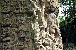
Maya stelae are monuments that were fashioned by the Maya civilization of ancient Mesoamerica. They consist of tall, sculpted stone shafts and are often associated with low circular stones referred to as altars, although their actual function is uncertain. Many stelae were sculpted in low relief, although plain monuments are found throughout the Maya region. The sculpting of these monuments spread throughout the Maya area during the Classic Period, and these pairings of sculpted stelae and circular altars are considered a hallmark of Classic Maya civilization. The earliest dated stela to have been found in situ in the Maya lowlands was recovered from the great city of Tikal in Guatemala. During the Classic Period almost every Maya kingdom in the southern lowlands raised stelae in its ceremonial centre.
Kʼinich Yoʼnal Ahk I, also known as Ruler 1, was an ajaw of Piedras Negras, an ancient Maya settlement in Guatemala. He ruled during the Late Classic Period, from 603–639 AD. It has been proposed that he began a new dynasty at Piedras Negras, following years of ineffective kings. As to how Kʼinich Yoʼnal Ahk I came to power, a consensus has not yet been reached, although it is known that he waged several successful wars against Palenque and Sak Tzʼiʼ. He was succeeded by his son, Itzam Kʼan Ahk I, in 639 AD and left behind several monuments, including stelae at Piedras Negras and a large mortuary temple now known as Pyramid R-5.

Yoʼnal Ahk III, also known as Ruler 5, was an ajaw of Piedras Negras, an ancient Maya settlement in Guatemala. He ruled during the Late Classic Period, from 758 to 767 AD. Yoʼnal Ahk III ascended to the throne upon the death of Itzam Kʼan Ahk II, who may have been Yoʼnal Ahk's father. He was succeeded by his probable brother, Haʼ Kʼin Xook in around 767 AD. Yoʼnal Ahk III left behind two surviving stelae at Piedras Negras, namely Stelae 14 and 16, the former of which has been called one of the finest niche stelae, according to Simon Martin and Nikolai Grube.

The North Acropolis of the ancient Maya city of Tikal in Guatemala is an architectural complex that served as a royal necropolis and was a centre for funerary activity for over 1300 years. The acropolis is located near the centre of the city and is one of the most studied of Maya architectural complexes. Excavations were carried out from 1957 to 1969 by the University of Pennsylvania, directed by Edwin M. Shook and William Coe.
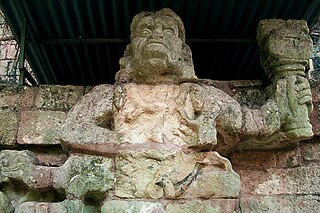
Tzi-Bʼalam was the tenth ruler of Copan. He was nicknamed Moon Jaguar by archaeologists. He was a son of Bʼalam Nehn, the 7th ruler. He was enthroned in May 553. His surviving monuments were found in the modern village of Copán Ruinas, which was a major complex during the Classic period. The most famous construction dating to his reign is the elaborate Rosalila phase of Temple 16, discovered entombed intact under later phases of the temple during archaeological tunneling work.

Kʼakʼ Chan Yopaat was the eleventh dynastic ruler at Copán. He was crowned as king in AD 578, 24 days after the death of Tzi-Bʼalam. At the time of his rule Copán was undergoing an unprecedented rise in population, with residential land use spreading to all available land in the entire Copán Valley. The two surviving stelae of Kʼakʼ Chan Yopaat contain long hard-to-decipher hieroglyphic texts and are the oldest monuments at the site to survive without being either broken or buried. He had a long reign, ruling at Copán for 49 years, and he died on 5 February 628. His name is recorded on four stelae erected by his successors, one of which describes a rite performed with relics from his tomb in AD 730, almost a hundred years after his death.

Kʼakʼ Yipyaj Chan Kʼawiil was a ruler of the Mayan city of Copán. He was the son of Kʼakʼ Joplaj Chan Kʼawiil. The early period of his rulership fell within Copán's hiatus but later on he began a programme of renewal in an effort to recover from the earlier disaster of the city. He built a new version of Temple 26, with the Hieroglyphic Stairway being reinstalled on the new stairway and doubled in length. Five life-size statues of seated rulers were installed seated upon the stairway. Kʼakʼ Yipyaj Chan Kʼawiil died in the early 760s and is likely to have been interred in Temple 11, although the tomb has not yet been excavated.

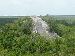
Caracol is the name given to a large ancient Maya archaeological site, located in what is now the Cayo District of Belize. It is situated approximately 40 kilometres south of Xunantunich and the town of San Ignacio Cayo, and 15 kilometers away from the Macal River. It rests on the Vaca Plateau at an elevation of 500 meters above sea-level, in the foothills of the Maya Mountains. Long thought to be a tertiary center, it is now known that the site was one of the most important regional political centers of the Maya Lowlands during the Classic Period. Caracol covered approximately 200 square kilometers, covering an area much larger than present-day Belize City and supported more than twice the modern city's population.