Charlotte River (Florida)

Last updated

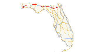
The Charlotte River (also Macaco River) is a former name for what was thought to be a continuous river draining Lake Okeechobee (formerly Lake Macaco) into Charlotte Harbor. Although an 1842 map indicates that the Charlotte was the same as the Caloosahatchee River, [1] , other sources distinguish the two from each other. [2] Most maps that include the river show it following what is now known as Shell Creek east from the Peace River and splitting into multiple branches, with the south branch receiving water from Lake Macaco, a north or northeast branch, and a central branch labeled as Lost Creek. [3] [4] The most prominent actual waterway near the east half of the supposed Charlotte River is Fisheating Creek

Lake Okeechobee freshwater lake in the state of Florida

Lake Okeechobee, also known as Florida's Inland Sea, is the largest freshwater lake in the state of Florida. It is the eighth largest natural freshwater lake in the United States and the second largest natural freshwater lake contained entirely within the contiguous United States. Okeechobee covers 730 square miles (1,900 km2), approximately half the size of the state of Rhode Island, and is exceptionally shallow for a lake of its size, with an average depth of only 9 feet. The Kissimmee River, located directly north of Lake Okeechobee, is the lake's primary source. The lake is divided between Glades, Okeechobee, Martin, Palm Beach, and Hendry counties. All five counties meet at one point near the center of the lake.

Caloosahatchee River River on the southwest coast of Florida, US

The Caloosahatchee River is a river on the southwest Gulf Coast of Florida in the United States, approximately 67 miles (108 km) long. It drains rural areas on the northern edge of the Everglades, east of Fort Myers. An important link in the Okeechobee Waterway, a manmade inland waterway system of southern Florida, the river forms a tidal estuary along most of its course and has become the subject of efforts to restore and preserve the Everglades.

Peace River (Florida) River in the United States of America

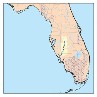
The Peace River is a river in the southwestern part of the Florida peninsula, in the U.S.A.. It originates at the juncture of Saddle Creek and Peace Creek northeast of Bartow in Polk County and flows south through Fort Meade Hardee County to Arcadia in DeSoto County and then southwest into the Charlotte Harbor estuary at Port Charlotte in Charlotte County. It is 106 miles (171 km) long and has a drainage basin of 1,367 square miles (3,540 km2). U.S. Highway 17 runs near and somewhat parallel to the river for much of its course. The river was called Rio de la Paz on 16th century Spanish charts. It appeared as Peas Creek or Pease Creek on later maps. The Creek Indians call it Talakchopcohatchee, River of Long Peas. Other cities along the Peace River include Fort Meade, Wauchula and Zolfo Springs.

The border between St. Johns and Monroe Counties was defined to follow the Charlotte River in 1823, [5] and remained there (with various counties replacing St. Johns to the north) until it was moved south to the township line (now the Charlotte-Lee border) in 1859. [6] Most maps postdating the discovery that the Charlotte River did not exist placed the line along the Caloosahatchee River. [7] [8]

Lee County, Florida County in Florida, United States

Lee County is located in southwest Florida on the Gulf Coast. As of the 2010 census, the population was 618,754. The county seat is Fort Myers, and the largest city is Cape Coral with an estimated 2016 population of 179,804. Lee County comprises the Cape Coral–Fort Myers, FL Metropolitan Statistical Area.

Related Research Articles

The Toledo War (1835–36), also known as the Michigan–Ohio War, was an almost bloodless boundary dispute between the U.S. state of Ohio and the adjoining territory of Michigan.

Punta Rassa, Florida CDP in Florida, United States

Punta Rassa is a census-designated place (CDP) in Lee County, Florida, United States. The population was 1,750 at the 2010 census. It is part of the Cape Coral-Fort Myers, Florida Metropolitan Statistical Area.

West Florida region

West Florida was a region on the northern coast of the Gulf of Mexico that underwent several boundary and sovereignty changes during its history. As its name suggests, it was formed out of the western part of former Spanish Florida, along with lands taken from French Louisiana; Pensacola became West Florida's capital. The colony included about two thirds of what is now the Florida Panhandle, as well as parts of the modern U.S. states of Louisiana, Mississippi, and Alabama.

Chattahoochee River River in Florida, United States

The Chattahoochee River forms the southern half of the Alabama and Georgia border, as well as a portion of the Florida - Georgia border. It is a tributary of the Apalachicola River, a relatively short river formed by the confluence of the Chattahoochee and Flint rivers and emptying from Florida into Apalachicola Bay in the Gulf of Mexico. The Chattahoochee River is about 430 miles (690 km) long. The Chattahoochee, Flint, and Apalachicola rivers together make up the Apalachicola–Chattahoochee–Flint River Basin. The Chattahoochee makes up the largest part of the ACF's drainage basin.

State Road 80 is a 123.5 miles (198.8 km) route linking US 41 Business in Fort Myers and State Road A1A in Palm Beach. The road is the northernmost of three linking Southwest Florida to South Florida via the Everglades. Due to increasing traffic, State Road 80 has experienced upgrades and widening in various sections since 2000.

The Caloosahatchee culture is an archaeological culture on the Gulf coast of Southwest Florida that lasted from about 500 to 1750 CE. Its territory consisted of the coast from Estero Bay to Charlotte Harbor and inland about halfway to Lake Okeechobee, approximately covering what are now Charlotte and Lee counties. At the time of first European contact, the Caloosahatchee culture region formed the core of the Calusa domain.

Mosquito County, Florida Former county in Florida, United States

Mosquito County is the historic name of an early county that once comprised most of the eastern part of Florida. Its land included all of present-day Volusia, Brevard, Indian River, St. Lucie, Martin, Seminole, Osceola, Orange, Lake, Polk and Palm Beach counties.

State Road 867 and County Road 867 together create a 14.6-mile (23.5 km) long road known as McGregor Boulevard in Lee County, Florida, paralleling the Caloosahatchee River between Punta Rassa and Fort Myers. The entire road was formerly state-maintained.

Enterprise, Florida Unincorporated community in Florida, United States

Enterprise is an unincorporated community in Volusia County, in the U.S. state of Florida, and its former county seat. Situated on the northern shore of Lake Monroe, it is flanked by the cities of DeBary and Deltona. Enterprise was once the head of navigation on the St. Johns River and at various times, the county seat for three different counties: Mosquito, which was renamed as Orange; and lastly, for Volusia, which was formed from part of Orange County.

U.S. Highway 1 (US 1) in Florida runs 545 miles (877 km) along the state's east coast– from Key West to its crossing of the St. Marys River into Georgia north of Boulogne –and south of Folkston. US 1 was designated through Florida when the United States Numbered Highway System was established in 1926. The road is maintained by the Florida Department of Transportation (FDOT).

Lake Monroe (Florida) lake of the United States of America

Lake Monroe is one of the lakes that make up the St. Johns River system. The port city of Sanford is situated along the southern shore, while DeBary and Deltona are located along the northern shore. Two major central Florida roadways that run near the lake are State Road 415 and Interstate 4. It forms the border of Seminole County and Volusia County It is the 8th largest lake in the Orlando metropolitan area, after Lake Jesup, 7 miles (11 km) to the south.

State Road 31 is a state highway in Southwest Florida in Lee, Charlotte, and DeSoto counties. It is about 36 miles long. The entire roadway is two lanes wide, even near Fort Myers. The highway crosses the Caloosahatchee River via the Wilson Pigott Bridge, a small drawbridge, a mile north of the southern terminus. The northern terminus is with an intersection of SR 70 near Arcadia. The southern terminus is with an intersection of SR 80 near Fort Myers Shores. The route is home to G. Pierce Wood Memorial Hospital, replacing the old De Soto Aircraft Field.

U.S. Route 17 in Florida highway in Florida

U.S. Route 17 (US 17) in Florida is a north–south United States Highway. It runs 317 miles (510 km) from the Punta Gorda, Florida Metropolitan Statistical Area northeast to the Greater Jacksonville Metropolitan Area.

U.S. Route 90 in Florida highway in Florida

U.S. Route 90 in the State of Florida is the northernmost west-to-east U.S. route in the state although it is one of the southernmost U.S. west-to-east routes in the rest of the United States. Highway 90 passes through the county seats of all 15 counties on its course in Florida, and is also the road upon which many of the county courthouses are located. It is never more than six miles (10 km) from I-10 throughout the state. It runs as a two-lane highway through most of the sparsely populated inland areas of the panhandle, becoming four-lanes through and near several towns. The speed limit is 55 mph (89 km/h) for all rural points west of Monticello, and it is 60 mph (97 km/h) on all rural points beginning in Madison County to Glen St. Mary.

References

  1. Sidney E. Morse and Samuel Breese, Florida, 1842
  2. John Lee Williams, The Territory of Florida, 1837, pp. 49-50
  3. J.T. Hinton, Map of the State of Florida, 1832
  4. S. Augustus Mitchell, Map of Florida according to the Latest Authorities, 1836
  5. "An Act to provide for the organization of a county south of Charlotte harbour in the Territory of Florida". Act of 1823.
  6. "An Act more definitely to establish the limits and boundaries of Monroe and Manatee counties". Act No. 64 (Chapter 922) of 1858.
  7. Thomas, Cowperthwait & Co., Map of Florida, 1850
  8. J.H. Colton & Co., Florida, 1855