- To be distinguished from Chazeau, Loire a commune in France merged with Firminy in 1959.
Chazeau is a settlement in Guadeloupe, on the island of Grande-Terre. It is located to the east of Quatre Chemins and Boisripeau.
Chazeau is a settlement in Guadeloupe, on the island of Grande-Terre. It is located to the east of Quatre Chemins and Boisripeau.

Stefansson Island is an uninhabited island in the Arctic Archipelago in the Kitikmeot Region of Nunavut, Canada. It has a total area of 4,463 km2 (1,723 sq mi), making it the 128th largest island in the world, and Canada's 27th largest island. The island is located in Viscount Melville Sound, with M'Clintock Channel to the east. It lies just off Victoria Island's Storkerson Peninsula, separated by the Goldsmith Channel. Stefansson Island's highest mount is 256 m (840 ft). A weather station, at 73°45′56″N105°17′44″W, is located on the northern part of the island as part of an automated weather station array operated by Environment and Climate Change Canada in the Arctic. The first European sighting of the island was in 1917 by Storker T. Storkerson who was travelling with Canadian explorer Vilhjalmur Stefansson (1879-1962), for whom the island was named.

St Catherine's Point is the southernmost point on the Isle of Wight. It is close to the village of Niton and the point where the Back of the Wight changes to the Undercliff of Ventnor.
Indiana Transmission is a Stellantis North America automobile factory in Kokomo, Indiana. The first plant, Indiana Transmission I, opened in 1998 and the second opened in 2003. In June 2010 Chrysler announced a 300 million dollar investment to retool and modernize the Indiana plant for production of a future eight-speed automatic transmission. The plant is not to be confused with Kokomo Transmission, a separate plant also located in Kokomo.

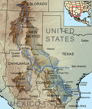
The Devils River in southwestern Texas, part of the Rio Grande drainage basin, has limited areas of whitewater along its length. It begins in northwest Sutton County, at 30°19′40″N100°56′31″W, where six watercourses come together, Dry Devils River, Granger Draw, House Draw, Jackson, Flat Rock Draw, and Rough Canyon. It flows southwest for 94 miles (151 km) through Val Verde County and empties into the northeastern shore of the Amistad Reservoir, an impoundment of the Rio Grande near Del Rio, Texas on the Texas/Mexico border, 29°27′33″N101°3′34″W. The discharge of the Devils River, as measured at IBWC gaging station 08-4494.00 near the river's mouth, averages 362 cubic feet per second (10.3 m3/s), with a maximum of 122,895 cubic feet per second (3,480 m3/s) and a minimum of 54 cubic feet per second (1.53 m3/s). Its drainage basin above that point is 10,259 square kilometres (3,961 sq mi).
The Volta Powerhouses are hydroelectric generation plants located in southern Shasta County, California, between Shingletown and Manton. Volta Powerhouse I 40°27′33″N121°51′56″W was built in 1901 by Keswick Electric Power Company; Volta Powerhouse II was built in 1980.
WAKV is a radio station broadcasting a classic country format. Licensed to Otsego, Michigan, it first began broadcasting in 1958 with the WDMC call sign.

Capecastle or Cape Castle is a small village and townland in County Antrim, Northern Ireland, between Armoy and Ballycastle. It is part of the Causeway Coast and Glens district.

Burnett is an unincorporated community in Otter Creek Township, Vigo County, in the U.S. state of Indiana.
Jabrun is a settlement in Guadeloupe in the commune of Morne-à-l'Eau, on the island of Grande-Terre. Chazeau, Malignon, and Jabrun-du-Sud are to the west.
Broad Branch is an unincorporated community in Calhoun County, Florida, United States. The community is located at the west end of County Road 392, and is named for a tributary to Cypress Creek.

Knockando is a village in Moray, Scotland. It is a farming centre and the location of both the Knockando distillery and the Tamdhu distillery.
Cherry Gardens is an unincorporated community in the City of Richmond, in the U.S. state of Virginia.

East Glenn is an unincorporated community in central Lost Creek Township, Vigo County, in the U.S. state of Indiana.

Prosechen Island is the northern of two rocky islands in Smyadovo Cove on the west coast of Rugged Island in the South Shetland Islands. The area was visited by early 19th century sealers. It is named after the settlement of Prosechen in Northeastern Bulgaria.
Milligan College is an unincorporated community and an area of Elizabethton, in Carter County, Tennessee. Milligan is home to Milligan University and Emmanuel Christian Seminary. All of Milligan has been annexed by the city of Elizabethton.
Clear Point is an unincorporated community in Benton County, Arkansas, United States.
Zewapeta is an unincorporated community in Scott County, in the U.S. state of Missouri.
Clouds is an unincorporated community in Claiborne County, Tennessee.

Bucktown is an unincorporated community in Dorchester County, in the U.S. state of Maryland.
Soğuksu Creek is a creek in Mersin Province, Turkey. It is a short creek formed by merging two small streams just north of Aydıncık ilçe (district). Like most other creeks in the province its flow rate fluctuates during the year. But even in the hottest season it doesn't dry up. It discharges to Mediterranean Sea at 36°08′07″N33°17′44″E.