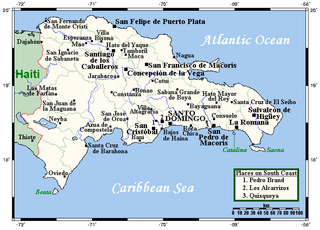
The Dominican Republic is a country in the West Indies that occupies the eastern five-eighths of Hispaniola. It has an area of 48,670 km², including offshore islands. The land border shared with Haiti, which occupies the western three-eighths of the island, is 376 km long. The maximum length, east to west, is 390 km from Punta de Agua to Las Lajas, on the border with Haiti. The maximum width, north to south, is 265 km from Cape Isabela to Cape Beata. The capital, Santo Domingo, is located on the south coast.

The Republic of Haiti comprises the western three-eighths of the island of Hispaniola, west of the Dominican Republic. Haiti is positioned east of the neighboring island of Cuba, between the Caribbean Sea and the North Atlantic Ocean. Haiti's geographic coordinates are at a longitude of 72° 25′ west and a latitude of 19° 00′ north.

Jimaní is the capital and the second largest city of the Independencia Province of the Dominican Republic. It serves as one of the two main thoroughfares to Haiti, with a duty-free open-air marketplace operating on the border with Haiti. The town suffered damages in the flash flood of May 25, 2004, which killed many citizens during the night and washed away hundreds of homes.

Pic Macaya National Park is one of two national parks of the Republic of Haiti. It is located in the country's southern peninsula, within the Massif de la Hotte. Featuring the country's last stand of virgin cloud forest, it encompasses more than 8,000 hectares. Elevations in the rugged park reach a maximum height of 2,347 meters above sea level at Pic Macaya, the second highest point in Haiti behind Pic la Selle. A majority of the park is composed of two tall peaks: Pic Macaya and Pic Formon.
La Visite National Park is one of the two national parks of the Republic of Haiti. La Visite is a part of the Massif de la Selle mountain range. Its highest peak is 2275 meters in elevation. The park covers approximately 11,419 hectares of land with 1897 hectares above 2000 meters in elevation, and consists mainly of pine forest, grasslands, and some montane broadleaf forest at an altitude above 1,700 m (5,600 ft). The Haitian government established the La Visite National Park in 1983. The capital, Port-au-Prince, is only 22 kilometers north from the park. The western boundary of La Visite is the ridge of the Massif de la Selle.
The Montagnes du Cibao are located in Haiti. The highest point of the range, Morne du Cibao, is 2,280 meters above sea level, making it the third highest peak in Haiti, behind Pic la Selle and Pic Macaya.

Pic Macaya is the second-highest mountain in Haiti, rising to an elevation of 2,347 metres above sea level. It is located in the Massif de la Hotte, 36 kilometres northwest of Les Cayes and 195 km (121 mi) west of Port-au-Prince. The mountain is located in the Pic Macaya National Park.

Kenscoff is a commune in the Port-au-Prince Arrondissement, in the Ouest department of Haiti, located in the foothills of the Chaîne de la Selle mountain range, some 10 kilometres to the southeast of the capital city of Port-au-Prince. The altitude is approximately 1500 meters, making the town the highest permanent settlement in the Caribbean. Because of its altitude, the temperature is on average cooler than the capital and during winter months can be chilly relative to the rest of the country. It has a population of around 52,200.

The Baoruco Mountain Range—Sierra de Baoruco is a mountain range located in the far southwestern region of the Dominican Republic. It is within Pedernales, Independencia, Barahona, and Baoruco Provinces.
The La Selle red-legged frog or Furcy robber frog is a species of frog in the Eleutherodactylidae family. It is endemic to southern Hispaniola and occurs in both Haiti and the Dominican Republic. Specifically, it occurs on the Massif de la Selle (Haiti) to the western Baoruco Mountain Range. Its natural habitats are upland mesic pine forests, where it is usually found under rocks and logs. It is threatened by habitat loss caused by logging and agriculture. It is known from protected areas, but habitat loss continues also within those areas.
Jean-Rabel is a commune located west of the city of Port-de-Paix and east of the city of the Môle-Saint-Nicolas Arrondissement, in the Nord-Ouest department of Haiti. As of 2015, the estimated adult population was 148,416.
Cerca-la-Source is an arrondissement (district) in the Centre department of Haiti. As of 2015, the population was 119,756 inhabitants. Postal codes in the Cerca-la-Source Arrondissement start with the number 54.
The Cordillera Central is the highest mountain range in the Dominican Republic and in all of the Caribbean region, running through the heart of the island of Hispaniola.
Pluto Glacier is a glacier on the east coast of Alexander Island, Antarctica, 10 nautical miles (18 km) long and 4 nautical miles (7 km) wide, which flows east into George VI Sound to the north of Succession Cliffs. Although Pluto Glacier is not located within nearby Planet Heights, the glacier was named in association with the mountain range along with many other nearby glaciers that are named after planets of the Solar System. The glacier was first photographed from the air on November 23, 1935, by Lincoln Ellsworth and mapped from these photos by W.L.G. Joerg. Roughly surveyed in 1936 by the British Graham Land Expedition (BGLE). Named by the United Kingdom Antarctic Place-Names Committee (UK-APC) for Pluto, then considered the ninth planet of the Solar System, following Falkland Islands Dependencies Survey (FIDS) surveys in 1948 and 1949.
The Selle is a river of Picardy, in France.

The wildlife of Haiti is important to the country because of its biodiversity. According to the World Conservation Monitoring Centre, Haiti is considered to be "one of the most biologically significant countries of the West Indies". With an estimated 5,600 plant species on the island of Hispaniola, some of which only occur in Haiti, 36% are considered as endemic to the island. A mountainous area country, it is situated in the western three-eighths of Hispaniola and shares a border with the Dominican Republic. There are nine life zones, from low desert to high cloud forests, as well as four mountain ranges, and hundreds of rivers and streams and the coral reefs in the seas that surround the islands. Issues of environmental damage, expanding population, deforesting and erosion are of concern; less than 2% of the original forest remains on account of deforestation. This degradation is traced from the 17th century to 19th century starting with the French colonization of the Haiti and population explosion during the 20th century and for the purpose of forestry and sugar-related industries, degraded the forests. and the environment.