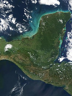
The Spanish conquest of Yucatán was the campaign undertaken by the Spanish conquistadores against the Late Postclassic Maya states and polities in the Yucatán Peninsula, a vast limestone plain covering south-eastern Mexico, northern Guatemala, and all of Belize. The Spanish conquest of the Yucatán Peninsula was hindered by its politically fragmented state. The Spanish engaged in a strategy of concentrating native populations in newly founded colonial towns. Native resistance to the new nucleated settlements took the form of the flight into inaccessible regions such as the forest or joining neighbouring Maya groups that had not yet submitted to the Spanish. Among the Maya, ambush was a favoured tactic. Spanish weaponry included broadswords, rapiers, lances, pikes, halberds, crossbows, matchlocks and light artillery. Maya warriors fought with flint-tipped spears, bows and arrows and stones, and wore padded cotton armour to protect themselves. The Spanish introduced a number of Old World diseases previously unknown in the Americas, initiating devastating plagues that swept through the native populations.

Champotón is a small city in Champotón Municipality in the Mexican state of Campeche, located at 19°21′N90°43′W, about 60 km south of the city of Campeche where the small Champotón river meets the coast of the Gulf of Mexico. At the 2010 census it had a population of 30,881.

The Caste War of Yucatán (1847–1901) began with the revolt of native Maya people of Yucatán, Mexico against the European-descended population, called Yucatecos. The latter had long held political and economic control of the region. A lengthy war ensued between the Yucateco forces in the north-west of the Yucatán and the independent Maya in the south-east. There was regular raiding between them.

Maní is a small city in Maní Municipality in the central region of the Yucatán Peninsula, in the Mexican state of Yucatán. It is about 100 km to the south south-east of Mérida, Yucatán, some 16 km east of Ticul. The village of Tipikal lies 6 km to the east.

Diego de Landa Calderón, O.F.M. was a Spanish bishop of the Roman Catholic Archdiocese of Yucatán. Historians describe him as a cruel and fanatical priest who led a violent campaign against idolatry. In particular, he burned almost all the Mayan manuscripts (codices) that would have been very useful in deciphering Mayan script, knowledge of Maya religion and civilization, and the history of the American continent.
Yucatec Maya, called mayaʼ tʼàan by its speakers, is a Mayan language spoken in the Yucatán Peninsula and northern Belize. To native speakers, the proper name is Maya and it is known only as Maya. The qualifier "Yucatec" is a tag linguists use to distinguish it from other Mayan languages. Thus the use of the term Yucatec Maya to refer to the language is scientific jargon or nomenclature.
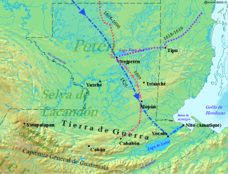
Martín de Ursúa y Arizmendi, Count of Lizárraga and of Castillo, was a Spanish Basque conquistador in Central America during the late colonial period of New Spain. Born in Olóriz, Navarre, he is noted for leading the 1696–97 expeditionary force which resulted in the fall of the last significant independent Maya stronghold, Nojpetén, located on an island in Lake Petén Itzá in the northern Petén Basin region of present-day Guatemala. He served as governor of the Yucatán until 1708, when he was named Governor-General of the Philippines. Around the time that he was named to that post, he was made a knight of the Order of Santiago. He died in Manila in 1715.

Kukulkan is the name of a Mesoamerican serpent deity. Prior to the Spanish Conquest of the Yucatán, Kukulkan was worshipped by the Yucatec Maya peoples of the Yucatán Peninsula, in what is now Mexico. The depiction of the Feathered Serpent is present in other cultures of Mesoamerica. Kukulkan is closely related to the deity Qʼuqʼumatz of the Kʼicheʼ people and to Quetzalcoatl of Aztec mythology. Little is known of the mythology of this Pre-Columbian era deity.
Jerónimo de Aguilar O.F.M. (1489–1531) was a Franciscan friar born in Écija, Spain. Aguilar was later involved with the 1519 Spanish conquest of Mexico, and with La Malinche he assisted Hernán Cortés in translating the indigenous language to Spanish.

Xelha is an archaeological site of the Maya civilization from pre-Columbian Mesoamerica, located on the eastern coastline of the Yucatán Peninsula, in the present-day state of Quintana Roo, Mexico. The etymology of the site's name comes from Yukatek Maya, combining the roots xel ("spring") and ha' ("water").

Chichen Itza was a large pre-Columbian city built by the Maya people of the Terminal Classic period. The archaeological site is located in Tinúm Municipality, Yucatán State, Mexico.

The Captaincy General of Yucatán was an administrative district of colonial Spain, created in 1617 to provide more autonomy for the Yucatán Peninsula, previously ruled directly by a simple governor under the jurisdiction of Audiencia of Mexico. Its creation was part of the, ultimately futile, Habsburg attempt in the late 16th century to prevent incursion into the Caribbean by foreign powers, which also involved the establishment of Captaincies General in Puerto Rico, Cuba, and neighboring Guatemala. With the addition of the title of captain general to the governor of Yucatán, the province gained greater autonomy in administration and military matters. Unlike in most areas of Spanish America, no formal corregidores were used in Yucatán, and instead the governor-captain general relied on other subordinate officials to handle the oversight of local districts. The Captaincy General remained part of the Viceroyalty of New Spain, with the viceroy retaining the right to oversee the province's governance, when it was deemed necessary, and the Audiencia of Mexico taking judicial cases in appeal. The province and captaincy general covered the territory that today are the States of Campeche, Quintana Roo, Tabasco, Yucatán, and nominally the northern areas of Petén and Belize.

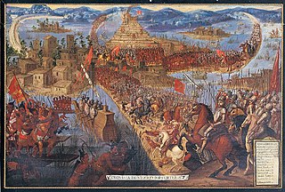
The Spanish conquest of the Maya was a protracted conflict during the Spanish colonisation of the Americas, in which the Spanish conquistadores and their allies gradually incorporated the territory of the Late Postclassic Maya states and polities into the colonial Viceroyalty of New Spain. The Maya occupied a territory that is now incorporated into the modern countries of Mexico, Guatemala, Belize, Honduras and El Salvador; the conquest began in the early 16th century and is generally considered to have ended in 1697.
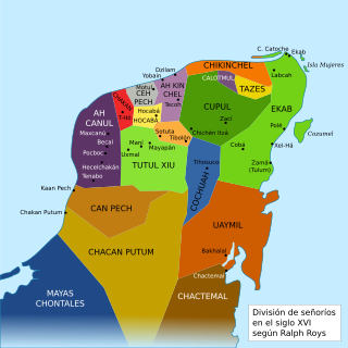
Chakán Putum was the name of a Mayan chiefdom of the southwestern Yucatán Peninsula, before the arrival of the Spanish conquistadors in the sixteenth century. It was named after the capital city Chakan Putum. The city had approximately 8000 houses. It was a major port.
Cupul or Kupul, was the name of a Maya chiefdom at time of the Spanish conquest of Yucatán. Cupul was one of the most extensive and densely populated Maya provinces on the Yucatán Peninsula. It was formed in the mid-fifteenth century after the fall of Mayapan and reached its maximum power during the sixteenth century, at the time of their own Spanish conquest led by the adelantado Francisco de Montejo. According to the Encyclopedia Yucatán in time, the Mayan voice ku-pul, means that throws the bouncing, giving a connotation referring to the Mayan ballplayers that existed in the region.
Ekab or Ecab was the name of a Mayan chiefdom of the northeastern Yucatán Peninsula, before the arrival of the Spanish conquistadors in the sixteenth century. In the fifteenth century most of Yucatán was controlled by the League of Mayapan. By 1441 there was civil unrest. The provinces of the League rebelled and formed sixteen smaller states. These states were called Kuchkabals. Most Kuchkabals were ruled by a Halach Uinik, but Ekab wasn't. It was divided up into several Batabil. Each Batabil was ruled over by a leader called a Batab. In Ekab the Batabs were supposed to have equal power, but the Batabs on Cozumel had much more power than the others.

The history of Maya civilization is divided into three principal periods: the Preclassic, Classic and Postclassic periods; these were preceded by the Archaic Period, which saw the first settled villages and early developments in agriculture. Modern scholars regard these periods as arbitrary divisions of chronology of the Maya civilization, rather than indicative of cultural evolution or decadence. Definitions of the start and end dates of period spans can vary by as much as a century, depending on the author. The Preclassic lasted from approximately 2000 BC to approximately 250 AD; this was followed by the Classic, from 250 AD to roughly 950 AD, then by the Postclassic, from 950 AD to the middle of the 16th century. Each period is further subdivided:

Ticul is a city and the municipal seat of the Ticul Municipality, Yucatán in Mexico. It is located some 100 km south of the state capital city of Mérida. In 2000 Ticul had a population of about 28,000 people. The majority are ethnically Maya.