Related Research Articles
The original inhabitants of Mauritania were the Bafour, presumably a Mande ethnic group, connected to the contemporary Arabized minor social group of Imraguen ("fishermen") on the Atlantic coast.

Senegal, officially the Republic of Senegal, is a country in West Africa, on the Atlantic Ocean coastline. Senegal is bordered by Mauritania to the north, Mali to the east, Guinea to the southeast and Guinea-Bissau to the southwest. Senegal nearly surrounds the Gambia, a country occupying a narrow sliver of land along the banks of the Gambia River, which separates Senegal's southern region of Casamance from the rest of the country. Senegal also shares a maritime border with Cape Verde. Senegal's economic and political capital is Dakar.
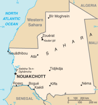
Mauritania, a country in the western region of the continent of Africa, is generally flat, its 1,030,700 square kilometres forming vast, arid plains broken by occasional ridges and clifflike outcroppings. Mauritania is the world’s largest country lying entirely below an altitude of 1,000 metres (3,300 ft). It borders the North Atlantic Ocean, between Senegal and Western Sahara, Mali and Algeria. It is considered part of both the Sahel and the Maghreb. A series of scarps face southwest, longitudinally bisecting these plains in the center of the country. The scarps also separate a series of sandstone plateaus, the highest of which is the Adrar Plateau, reaching an elevation of 500 metres or 1,640 feet. Spring-fed oases lie at the foot of some of the scarps. Isolated peaks, often rich in minerals, rise above the plateaus; the smaller peaks are called Guelbs and the larger ones Kedias. The concentric Guelb er Richat is a prominent feature of the north-central region. Kediet ej Jill, near the city of Zouîrât, has an elevation of 915 metres or 3,002 feet and is the highest peak.

Saint Louis or Saint-Louis, is the capital of Senegal's Saint-Louis Region. Located in the northwest of Senegal, near the mouth of the Senegal River, and 320 km north of Senegal's capital city Dakar, it has a population officially estimated at 258,592 in 2021. Saint-Louis was the capital of the French colony of Senegal from 1673 until 1902 and French West Africa from 1895 until 1902, when the capital was moved to Dakar. From 1920 to 1957, it also served as the capital of the neighboring colony of Mauritania.

Kaédi is the largest city and administrative center of the Gorgol Region of Southern Mauritania, located on the border with Senegal. It is approximately 435 km from Mauritania's capital, Nouakchott.

The Mauritania–Senegal Border War was a conflict fought between the West African countries of Mauritania and Senegal along their shared border during 1989–1991. The conflict began around disputes over the two countries' River Senegal border and grazing rights, and resulted in the rupture of diplomatic relations between the two countries for several years, the creation of thousands of refugees from both sides, as well as having a significant impact on domestic Senegalese politics.

The Tukulor people, also called Toucouleur or Haalpulaar, are a West African ethnic group native to Futa Tooro region of Senegal. There are smaller communities in Mali and Mauritania. The Toucouleur were Islamized in the 11th century; their early and strong Islamic heritage, which is seen as a defining feature, is a "matter of great pride for them". They have been influential in the spread of Islam to West Africa in the medieval era, later founded the vast Toucouleur Empire in the 19th century under Omar Saidou Tall that led a religious war against their neighboring ethnic groups and the French colonial forces.
The Bafour or Bafur are a group of people inhabiting Mauritania and Western Sahara. Their origins most likely ultimately lie in the Mandé peoples, only to later be absorbed by groups such as the Wolof, Serer, Fulani, or Tuareg. Scholars such as H.T. Norris describe "Bafur (Bafour)" as a loose term to encompass the pre-Sanhaja peoples, who were "part Berber, part Negro, and part Semite." And others describe them as Mandé agriculturalists who inhabited the area prior to the arrival of the Berbers. Others say they occupied these territories in the 15th century and, before the end of the 17th century, and were comprised by various groups, including the Wolof, Berber and Fula.

Rosso is the major city of south-western Mauritania and capital of Trarza region. It is situated on the Senegal River at the head of the river zone allowing year-round navigation. The town is 204 km south of the capital Nouakchott. The Arabic name is Al-Quwarib.

The Wolof people are a West African ethnic group found in northwestern Senegal, the Gambia, and southwestern coastal Mauritania. In Senegal, the Wolof are the largest ethnic group (~43.3%), while elsewhere they are a minority. They refer to themselves as Wolof and speak the Wolof language, in the West Atlantic branch of the Niger–Congo family of languages.

The African Liberation Forces of Mauritania is an illegal and exiled paramilitary organization for Black natives and inhabitants of Mauritania.
The Serer people are a West African ethnoreligious group. They are the third-largest ethnic group in Senegal, making up 15% of the Senegalese population. They are also found in northern Gambia and southern Mauritania.

The Emirate of Trarza was a precolonial state in what is today southwest Mauritania. It has survived as a traditional confederation of semi-nomadic peoples to the present day. Its name is shared with the modern Region of Trarza. The population, a mixture of Berber tribes, had been there for a long time before being conquered in the 11th century by Hassaniya Arabic speakers from the north. Europeans later called these people Moors/Maures, and thus have titled this group "the Trarza Moors".
Located in the Sahelian and Saharan zones, Mauritania has one of the poorest agricultural bases in West Africa. Most important to the rural economy has been the livestock subsector. Between 1975 and 1980, herding engaged up to 70 percent of the population, and sedentary farmers constituted about 20 percent of the population. The vast majority of the population lived in the southern one-third of the country, where rainfall levels were high enough to sustain cattle herding. Farming was restricted to the narrow band along the Senegal River where rainfall of up to 600 millimeters per year and annual river flooding sustained crop production as well as large cattle herds. In the dry northern two-thirds of the country, herding was limited to widely scattered pastoral groups that raised camels, sheep, and goats, and farming was restricted to date palms and minuscule plots around oases.

Precolonial Mauritania, lying next to the Atlantic coast at the western edge of the Sahara Desert, received and assimilated into its complex society many waves of Saharan migrants and conquerors.

The period from the mid-nineteenth to mid-twentieth centuries is the colonial period in Mauritania.

This article is about the history of Mauritania from 1960 to 1978. Mauritania, officially the Islamic Republic of Mauritania, is an Arab Maghreb country in West Africa. It is bordered by the Atlantic Ocean in the west, by Morocco in the north, by Algeria in the northeast, by Mali in the east and southeast, and by Senegal in the southwest. It is named after the ancient Berber Kingdom of Mauretania, which later became a province of the Roman Empire, even though the modern Mauritania covers a territory far to the south of the old Berber kingdom that had no relation with it.

Mauritania–Senegal relations are the foreign relations between Mauritania and Senegal, two neighbouring countries in West Africa.

Mauritania, officially the Islamic Republic of Mauritania, is a sovereign country in West Africa. It is bordered by the Atlantic Ocean to the west, Western Sahara to the north and northwest, Algeria to the northeast, Mali to the east and southeast, and Senegal to the southwest. Mauritania is the 11th-largest country in Africa and the 28th-largest in the world, and 90% of its territory is situated in the Sahara. Most of its population of 4.4 million lives in the temperate south of the country, with roughly one-third concentrated in the capital and largest city, Nouakchott, located on the Atlantic coast.

The people of Mauritania are nearly all adherents of Sunni Islam of Maliki school of jurisprudence, influenced with Sufism. Mauritania is a country in Africa, bordering Algeria, Mali, Senegal, and the Western Sahara. Officially, 100% of the Mauritanian citizens are Muslim, although there is a small community of Christians, mainly of foreign nationality. The two largest Sufi Muslim tariqas in Mauritania are Tijaniyyah and Qadiriyya. Because of the ethnic and tribal divisions in the country, religion is seen by the government as essential for national unity.
References
Library of Congress on Chemama
Mauritanian History- French Colonial era
| | This Mauritania location article is a stub. You can help Wikipedia by expanding it. |