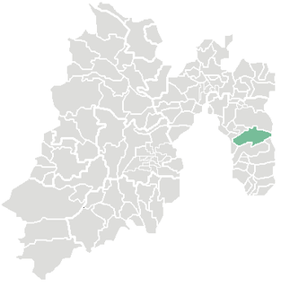
Xico is a city in the State of Mexico, Mexico. It serves as the municipal seat of Valle de Chalco municipality, with which it is, for all practical purposes, coterminous. The municipality lies adjacent to the east side of the Federal District and is part of the Mexico City metropolitan area. The city and municipality lie on the old lakebed of Lake Chalco, which was drained like much of the Basin of Mexico. The city name comes from the nearby Xico hill and the name of the municipality comes from the old lake plus a reference to the "Programa Nacional de Solidaridad" which was initiated here. The municipality's glyph and shield make reference to both names. It is a distinct entity from the city and municipality of Chalco, which is nearby. "Chalco" in both names refers to the Chalca tribe that were one of the original inhabitants of the area.

Greater Mexico City refers to the conurbation around Mexico City, officially called Valley of Mexico Metropolitan Area, constituted by Mexico City itself composed of 16 Municipalities—and 41 adjacent municipalities of the states of Mexico and Hidalgo. For normative purposes, however, Greater Mexico City most commonly refers to the Metropolitan Area of the Valley of Mexico an agglomeration that incorporates 18 additional municipalities. As of 2016 an estimated 21,157,000 people lived in Greater Mexico City, making it the largest metropolitan area in North America. It is surrounded by thin strips of highlands which separate it from other adjacent metropolitan areas, of which the biggest are Puebla, Toluca, and Cuernavaca-Cuautla, and together with which it makes up the Mexico City megalopolis.

La Paz is a municipality in the State of Mexico, Mexico, with its seat at the town of Los Reyes Acaquilpan. It is located on the dividing line between Mexico State and the eastern edge of the Federal District and is part of the Greater Mexico City area. The area was part of a region called "Atlicpac" which in Náhuatl means 'above or at the edge of water.' The current city's/municipality's glyph symbolizes water.
Chalco de Díaz Covarrubias is a city that is municipal seat of the surrounding municipality of Chalco. It lies in the eastern part of the State of Mexico just east of the Federal District of Mexico and is considered part of the Mexico City metropolitan area.
Ixtapaluca is a city and a municipality in the eastern part of the State of Mexico in Mexico. It lies between the Federal District and the western border of the state of Puebla. The name Ixtapaluca means "Where the salt gets wet".

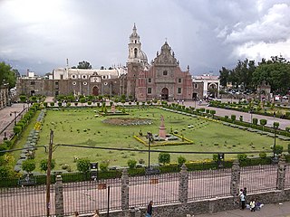
Valle de Chalco, officially named Valle de Chalco Solidaridad, is a municipality located in the State of Mexico, Mexico, on the eastern outskirts of the metropolitan area of Mexico City. Formerly part of the municipality of Chalco, it was split off as a separate entity in 1994, during the presidency of Salinas de Gortari, under his Programa Nacional de Solidaridad. The municipality lies on the old bed of Lake Chalco, which was substantially drained in the nineteenth century. Technically, the municipal seat is Xico, after a high point of land that once formed an island, and now remains as a small hill within an otherwise monotonous, urban expanse. "Chalco" refers to the Chalca tribe, whose territory covered the area around the lake, prior to the Spanish Conquest of Mexico.

Chimalhuacán is a city and municipality located in the eastern part of State of Mexico, Mexico. It lies just outside the northeast border of the Federal District and is part of the Greater Mexico City urban area.
Chicoloapan de Juárez is the municipal seat and largest city in the municipality of Chicoloapan in State of Mexico, Mexico. It is located in the eastern part of the state, just east of Chimalhuacán and northeast of the Federal District, within the Greater Mexico City urban area.
Federal Highway 115 is a Federal Highway of Mexico. The highway travels from Ixtapaluca, State of Mexico in the north to Izúcar de Matamoros, Puebla in the south. Federal Highway 115 is co-signed with Mexican Federal Highway 160 from Izúcar de Matamoros to north of Cuautla in Cuautlixco, Morelos.
Acozac (Ixtapaluca) is an archaeological site located in the Municipality of Ixtapaluca, State of Mexico, Mexico. The site is at kilometer 30 of federal road México - Puebla, towards Ixtapaluca.
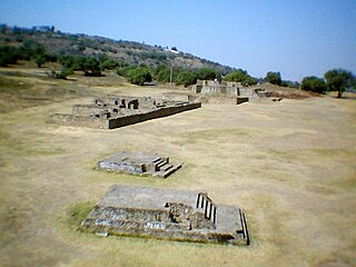
Chimalhuacán is an archeological site located in the city and municipality of Chimalhuacán Atenco in the eastern part of Mexico State, Mexico. It lies just outside the northeast border of the Federal District. The name derives from the Nahuatl words “chimalli” (shield), hua and can (place), this would mean "Place of Shields".The ancient name of the city by its founders was “Chimalhuacantoyac”.The word Atenco, is also Nahuatl; A, “water”; tentli, “lip” and co, “place”, hence would mean “at the water side”.

Arturo Lemus Beltran is a Mexican artist who entered the field at the age of 23, with no previous interest or training until he was awarded a scholarship to the Casa Lamm to study. He began exhibiting before his graduation in 2010 and since has had his work shown in Mexico, Canada and the United States as well as sold at auction for charity along with much better known names. He is also involved in a number of Japanese and Israeli civil associations and is a founding member of the Expresión Urbana Popular group, which promote art among young people.

Mexibús is a bus rapid transit (BRT) system that is located in the Greater Mexico City part of the State of Mexico, which surrounds Mexico City proper through 95 stations.

The 2014 Guerrero earthquake occurred with a moment magnitude of 7.2 that hit the state of Guerrero, close to Acapulco, Mexico, on 18 April at 14:27:26. The epicenter occurred 265 kilometers southwest of Mexico City and at a depth of 24 kilometers. Thrust motion at shallow depths is what caused the earthquake. This was broadly consistent with a slip on or near the Guerrero Seismic Gap, a boundary between the Cocos and North American plates along the Pacific Coast approximately 200 kilometers long. The shaking was felt in states as far away as Puebla and Tlaxcala.
Andrés Aguirre Romero is a Mexican politician from the Institutional Revolutionary Party. He currently serves as a federal deputy in the LXIII Legislature of the Mexican Congress representing the XXXIX Federal Electoral District of the State of Mexico.
San Francisco Acuautla is located in the eastern part of the Estado de Mexico to 4 kilometers from the county seat of Ixtapaluca; Coatepec bordered on the north, south to the suburbs of Ixtapaluca and Ranch San Andrés, east to the town Manuel Avila Camacho and the suburbs of Tlapacoya Ayotla and finally west to the Magdalena Atlicpa.
Federal Highway 150D is a toll highway connecting Mexico City to Veracruz City via Puebla City and Córdoba. It serves as one of the backbones of Mexico's toll road system. The road is primarily operated by Caminos y Puentes Federales, which charges cars 520 pesos to travel Highway 150D, with one segment in the Puebla metropolitan area built and maintained by OHL and PINFRA.
The Club Deportivo Nuevo Chimalhuacán, commonly known as Nuevo Chimalhuacán, is a Mexican football club based in Chimalhuacán. The club was founded in 2011, and currently plays in the Serie B of Liga Premier.
Itzel Nayelí Montaño García is an supposed Mexican spree killer accused of a series of crimes committed in the municipality of Chimalhuacán. The series of attacks were random against strangers and were committed by a woman who attacked her victims in the back by stabbing their necks. In total, a total of 7 attacks occurred, 2 of them fatal. She was named "The Decapitator of Chimalhuacán" by the media. She was disorganized, sedentary and hedonistic, highlighting the fact that their attacks were committed "body to body", an unusual modus operandi in female spree killers.

