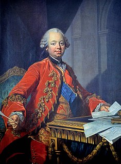
Étienne-François, Marquis de Stainville, 1er Duc de Choiseul was a French military officer, diplomat and statesman. Between 1758 and 1761, and 1766 and 1770, he was Foreign Minister of France and had a strong influence on France's global strategy throughout the period. He is closely associated with France's defeat in the Seven Years War and subsequent efforts to rebuild French prestige.

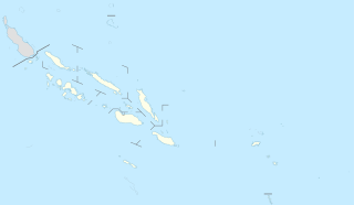
The Choiseul Province is one of the nine provinces of Solomon Islands. It lies southeast of Bougainville (part of Papua New Guinea, west of Santa Isabel and north of Vella la Vella, Kolombangra & New Georgia. In the 2009 national census its population is 26,372.

The Choiseul pigeon is an extinct species of bird in the pigeon and dove family, Columbidae. It was endemic to the island of Choiseul in the Solomon Islands, although there are unsubstantiated reports that it may once have lived on several nearby islands. The last confirmed sighting was in 1904. Other common names were Solomons crested pigeon, Solomon Islands crowned-pigeon and Kuvojo.

The Northern Solomons were the more northerly group of islands in the Solomon Islands archipelago over which Germany declared a protectorate in 1885. Initially the German Solomon Islands Protectorate included Choiseul, Santa Isabel, the Shortlands and Ontong Java Islands, but in 1900 these islands were transferred to the British Solomon Islands Protectorate. The largest of the Solomon Islands, Bougainville, continued under German administration until World War I when it fell to Australia, and after the war, it formally passed to Australian jurisdiction under a League of Nations mandate.

Taro Island is a small island in Solomon Islands with 507 inhabitants, capital of Choiseul Province and is located in Choiseul Bay off the northwest coast.

The Raid on Choiseul was a small unit engagement that occurred from October 28 to November 3, 1943, during the Solomon Islands campaign, and was launched to divert Japanese from the Allied landings at Cape Torokina. During the raid, United States Marines from the 2nd Parachute Battalion, led by Lt Col. Victor "Brute" Krulak, landed on Japanese occupied Choiseul in the northern Solomon Islands and carried out raids on Japanese army and navy forces over a 40 kilometer (25 mi) area over the course of seven days.

Gizo is the capital of the Western Province in Solomon Islands. With a population of 6,154, it is the second largest town in the country. It is situated on Ghizo Island approximately 380 kilometres west-northwest of the capital, Honiara, and is just southwest of the larger island of Kolombangara.
Fauro Island is an island of the Shortland Islands archipelago, located in the Western Province of the Solomon Islands, located at 6°55′S156°4′E. Along the center spine of the island are Mount Pauboleala with an elevation of 574', Mount Lalauka with an elevation of 517', and Sharp Peak with an elevation of 484'.

Romang is an island, part of Barat Daya Islands in Indonesia, located at 7.5833333°S 127.4333333°E, east of Wetar Island. Alternate names in use are Roma, Romonu and Fataluku. It is included within the Terselatan Islands District within the Barat Daya Islands Regency of the Maluku Province; the District also includes the smaller Kisar Island further south.
Choiseul Bay Airport is an airport at Choiseul Bay on Taro Island, part of the Choiseul Province in the Solomon Islands.
Cyprian Bridge Island is a small island located among the Solomon Islands. The island lies at a latitude of -6.85 and a longitude of 156.18333. It is an uninhabited volcanic island that lies between the islands of Fauro and Choiseul. The island lies within Choiseul Province.
Wagina Island—or as spelled in colonial times, Vaghena Island—is a small island in the Solomon Islands with 1636 inhabitants, most of whom live along the shores of Kenli Bay, where a small docking station is built for both residents and visitors. The easiest way to reach Wagina is by plane to Kaghau Airport, Choiseul Province, from Honiara. From Kagau it takes only 45 – 60 minutes by OBM to Wagina.

Kekaha Kai State Park, formerly known as Kona Coast State Park, is a beach park located along the north Kona coast on the island of Hawaiʻi. The main beach areas are Maniniʻowali Bay, Makalawena beach at Puʻu Aliʻi Bay, and Mahaiʻula Bay. The park's name originates from the Hawaiian language words ke kaha kai which translate to "the shore line" in English.
Bougainville Strait separates Choiseul Island, part of the Solomon Islands from Bougainville Island, the next to the northward and part of Papua New Guinea. It was first passed through in 1768 by Louis Antoine de Bougainville, who named it. A Lieutenant John Shortland of the Royal Navy sailed through it in 1788, giving the name of Treasury Islands to the numerous islands, lying in the strait. He named the strait after himself, but it later became known as Bougainville.
Rob Roy Island, native name Velaviru, is an island in the Solomon Islands located off the South East coast of Choiseul Island; it is located in Choiseul Province.
Arnarvon Islands are a group of islands in Solomon Islands; they are located in Isabel Province and nearby to Wagina Island in Choiseul Province.
Babatana, also spelled Mbambatana, is the principal indigenous language of Choiseul Province, Solomon Islands. Although native to the South Choiseul coastline area between Sepa and the Manggo Bay area, the use of this language has spread across much of Choiseul Island and it is generally understood, much like Solomon Islands Pijin, across the province as a second or third language.
Masamasa is an island of the Shortland Islands Archipelago, located in the Western Province of the Solomon Islands in the Pacific Ocean. The estimated terrain elevation above sea level is some 97 meters. To the east lies Fauro Island, to the south lies Piedu Island (Piru), and to the east lies the northern tip of Choiseul Island.


