
Ecuador is a country in western South America, bordering the Pacific Ocean at the Equator, for which the country is named. Ecuador encompasses a wide range of natural formations and climates, from the desert-like southern coast to the snowcapped peaks of the Andes mountain range to the plains of the Amazon Basin. Cotopaxi in Ecuador is one of the world's highest active volcanos. It also has a large series of rivers that follow the southern border and spill into the northwest area of Peru.

The Humboldt–Toiyabe National Forest (HTNF) is the principal U.S. National Forest in the U.S. state of Nevada, and has a smaller portion in Eastern California. With an area of 6,289,821 acres (25,454.00 km2), it is the largest U.S. National Forest outside Alaska.

The Caucasus Mountains are a mountain system at the intersection of Europe and Asia. Stretching between the Black Sea and the Caspian Sea, it is surrounded by the Caucasus region and is home to Mount Elbrus, the highest peak in Europe at 5,642 metres (18,510 ft) above sea level.

The Ouachita Mountains, simply referred to as the Ouachitas, are a mountain range in western Arkansas and southeastern Oklahoma. They are formed by a thick succession of highly deformed Paleozoic strata constituting the Ouachita Fold and Thrust Belt, one of the important orogenic belts of North America. The Ouachitas continue in the subsurface to the northeast where they make a poorly understood connection with the Appalachians and to the southwest where they join with the Marathon uplift area of West Texas. Together with the Ozark Plateaus, the Ouachitas form the U.S. Interior Highlands. The highest natural point is Mount Magazine at 2,753 feet.

Temperate rainforests are coniferous or broadleaf forests that occur in the temperate zone and receive heavy rainfall.

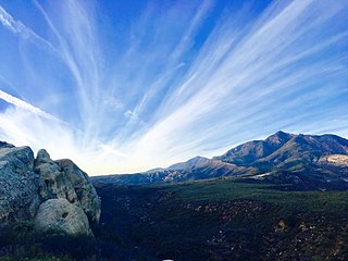
The San Jacinto Mountains are a mountain range in Riverside County, located east of Los Angeles in southern California in the United States. The mountains are named for one of the first Black Friars, Saint Hyacinth, who is a popular patron in Latin America.

The Chiricahua Mountains massif is a large mountain range in southeastern Arizona which is part of the Basin and Range province of the west and southwestern United States and northwest Mexico; the range is part of the Coronado National Forest. The highest point, Chiricahua Peak, rises 9,759 feet (2,975 m) above sea level, approximately 6,000 feet (1,800 m) above the surrounding valleys. The range takes its name from the Chiricahua Apaches native to the region.

The Sierra Madre Oriental is a mountain range in northeastern Mexico. The Sierra Madre Oriental is part of the American Cordillera, a chain of mountain ranges (cordillera) that consists of an almost continuous sequence of mountain ranges that form the western "backbone" of North America, Central America, South America and Antarctica.

Hunter Mountain is in the towns of Hunter and Lexington, just south of the village of Hunter, in Greene County, New York, United States. At approximately 4,040 feet (1,231 m) in elevation, it is the highest peak in the county and the second-highest peak in the Catskill Mountains.

The Kootenai National Forest is a national forest located in the far northwestern section of Montana and the northeasternmost lands in the Idaho panhandle in the United States, along the Canada–US border. Of the 2.2 million acres (8,900 km2) administered by the forest, less than 3 percent is located in the state of Idaho. Forest headquarters are located in Libby, Montana. There are local ranger district offices in Eureka, Fortine, Libby, Trout Creek, and Troy, Montana. About 53 percent of the 94,272-acre (381.51 km2) Cabinet Mountains Wilderness is located within the forest, with the balance lying in neighboring Kaniksu National Forest.

Boise National Forest is a National Forest covering 2,203,703 acres (8,918.07 km2) of the U.S. state of Idaho. Created on July 1, 1908, from part of Sawtooth National Forest, it is managed by the U.S. Forest Service as five units: the Cascade, Emmett, Idaho City, Lowman, and Mountain Home ranger districts.
Los Padres National Forest is a United States national forest in southern and central California. Administered by the United States Forest Service, Los Padres includes most of the mountainous land along the California coast from Ventura to Monterey, extending inland. Elevations range from sea level to 8,847 feet (2,697 m).

Slide Mountain is the highest peak in the Catskill Mountains of the U.S. state of New York. It is located in the town of Shandaken in Ulster County. While the 4,180-foot (1,270 m) contour line on topographic maps is generally accepted as its height, the exact elevation of the summit has never been officially determined by the U.S. Coast and Geodetic Survey, and many informal surveys suggest the mountain may actually top 4,200 feet above sea level.

The Intermountain West, or Intermountain Region, is a geographic and geological region of the Western United States. It is located between the front ranges of the Rocky Mountains on the east and the Cascade Range and Sierra Nevada on the west.

The Watagan Mountains or Watagans or Wattagan Mountains, a mountain range that is part of the Great Dividing Range, is located on the Lower Hunter region of New South Wales, Australia. The range is situated between the Upper Hunter River catchment and the Tuggerah Lakes. The Watagans are a popular tourist location and are close to Newcastle, Sydney and the Central Coast.

Abkhazia is a region in South Caucasus. It is de facto independent republic, but is mostly internationally recognized as part of Georgia. The article deals with the geography and climate of Abkhazia.

The Esmeraldas woodstar is a rare, neotropical species of hummingbird in the family Trochilidae. There are six different species in the woodstar genus. Most of them are poorly studied due to their small size, extremely similar resemblance to each other, and rarity. Esmeraldas woodstars are one of the smallest bird species. They are sexually dimorphic. The main difference between sexes is that males have a bright purple throat. Esmeraldas woodstars are found only on the Pacific coast of west Ecuador in semi-deciduous to evergreen forests. They feed on the nectar of flowering shrubs and trees. The main threat to this species is deforestation. Esmeraldas woodstars are Vulnerable and require habitat protection.

The Boulder Mountains are part of the Rocky Mountains in the western United States. Located in central Idaho, they stretch from a few miles north of Ketchum to north to near Challis, and part of the range is within the Sawtooth National Recreation Area (SNRA) and partially within the Hemingway–Boulders Wilderness. The highest point in the range is Ryan Peak, at 11,714 feet (3,570 m) above sea level.

Colonche is an alcoholic red coloured drink made by Mexicans for thousands of years with tuna, the fruits of "nopal", especially with tuna cardona, the fruits of Opuntia streptacantha.

Pennsylvania State Game Lands Number 58 are Pennsylvania State Game Lands in Columbia County, Pennsylvania, in the United States. They are one of six State Game Lands in Columbia County and Montour County and are the second-largest of those State Game Lands. The game lands have an area of 12,646 acres and are mostly forested. Numerous streams are within the game land's boundaries and several game animals inhabit the area. There is a high level of bird biodiversity. Recreational opportunities in the state game lands include a rifle range and several trails.