English usually refers to:
This is a partial index of Wikipedia articles treating natural languages, arranged alphabetically and with (sub-) families mentioned. The list also includes extinct languages.

Guanacaste is a province of Costa Rica located in the northwestern region of the country, along the coast of the Pacific Ocean. It is bordered by Nicaragua to the north, Alajuela Province to the east, and Puntarenas Province to the southeast. It is the most sparsely populated of all the provinces of Costa Rica. The province covers an area of 10,141 square kilometres (3,915 sq mi) and as of 2010, had a population of 354,154, with annual revenue of $2 million.
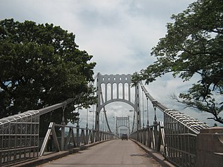
Choluteca is a municipality and the capital city of the Honduran department of the same name. Situated in southern Honduras between El Salvador and Nicaragua, the city is generally considered the regional centre of southern Honduras and is a major transit point on the Pan-American Highway. It has a major bus station and is home to the regional light (ENEE) and water (SANAA) utilities. The city is located on the Choluteca River, near the centre of the department. An arching silver bridge crosses the river into the city.
Teustepe is a municipality in the Boaco department of Nicaragua. It has a population of 26,800 and an extension of 645.73 km2. The capital is the town of Teustepe, 94 km. from Managua with a population of 3,500.
Mangue, Mangué or Mangüé may refer to:
Mangue, also known as Chorotega, is an extinct Oto-Manguean language ancestral to Nicaragua, Honduras and Costa Rica. The ethnic population numbered around 10,000 in 1981. Chorotega-speaking peoples included the Mangue and Monimbo. The dialects were known as: Mangue proper in western Nicaragua, which was further subdivided into Dirian and Nagrandan; Choluteca in the region of Honduras' Bay of Fonseca; and Orotiña in Costa Rica's Nicoya Peninsula.

The official language of Nicaragua is Spanish; however, Nicaraguans on the Caribbean coast speak indigenous languages and also English. The communities located on the Caribbean coast also have access to education in their native languages. Additionally, Nicaragua has four extinct indigenous languages.
The pre-Columbian history of Costa Rica extends from the establishment of the first settlers until the arrival of Christopher Columbus to the Americas.
The extinct Manguean languages were a branch of the Oto-Manguean family. They were Chorotega of Costa Rica and Nicaragua, and Chiapanec of Mexico.
Nicarao was said to be the name of an indigenous chieftain or cacique who presided over a territory in southwestern Nicaragua during the early 16th century. Based on research done by historians in 2002, it was discovered that his real name was Macuilmiquiztli.

Asociación Deportiva Guanacasteca is a Costa Rican football team based in Nicoya, Guanacaste. They currently play in the Costa Rican First Division. Their home stadium is Estadio Chorotega.

The Cacaopera people also known as the Matagalpa or Ulúa., are an indigenous people in what is now El Salvador and Nicaragua.

Indigenous people of Costa Rica, or Native Costa Ricans, are the people who lived in what is now Costa Rica prior to European and African contact and the descendants of those peoples. About 114,000 indigenous people live in the country, comprising 2.4% of the total population. Indigenous Costa Ricans strive to keep their cultural traditions and languages alive.
Matambú is a district of the Hojancha canton, in the Guanacaste province of Costa Rica.

The Kingdom of Nicoya, also called Cacicazgo or Lordship of Nicoya, was an indigenous nation that comprised much of the territory of the current Guanacaste Province, in the North Pacific of Costa Rica. Its political, economic and religious center was the city of Nicoya, located on the peninsula of the same name, which depends on several provinces located on both banks of the Gulf of Nicoya, as well as numerous tributary villages. In the 16th century, prior to the arrival of Europeans, Nicoya was the most important chiefdom of the North Pacific of present-day Costa Rica.
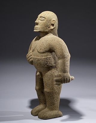
The Huetares were an important indigenous group of Costa Rica, who in the mid-16th century lived in the center of what is now the country. They are also mentioned with the name of güetares or pacacuas. Huetares were the most powerful and best-organized indigenous nation in Costa Rica upon the arrival of the Spaniards. During the 16th century, various chieftains dominated from the Costa Rican Atlantic coast to the Atlantic Slope. The Spanish chronicles mention a myriad of towns and the kings that ruled them, among them the Garabito Empire, located on the Central Atlantic Slope and the Tárcoles River basin, to the Virilla River and the Cordillera Central; the Kingdom of Pacaca, in the current canton of Mora, and the Lordship of el El Guarco, in the current Guarco Valley, in the Cartago Province, to the plains of the Central Caribbean and Chirripó. Their culture belonged to the Intermediate Area, and it stood out mainly for their works in stone, such as metates, sculptures, tables and ceremonial altars; and the non-practice of anthropophagy or cannibalism. Its language, the Huetar language, one of the so-called Chibcha languages, became the Lingua franca of the country. Although this language is extinct, it survives in a large number of place names in Costa Rica such as Aserrí, Tucurrique or Barva.

The empire, domain or lordship of King Garabito was a vast territory controlled by Huetar King Garabito and that extended through most of the Central Valley of Costa Rica from the Virilla River in modern San José to the Atlantic Slope in what is now the north of the country. Garabito's domain transcended the borders of the Western Huetar Kingdom where it had multiple vassal populations such as Coyoche, Abacara, Chucasque, Cobobici, Cobux, Yurustí and Barva, and also included several submissive peoples but not incorporated into their kingdom; the Botos, Tises and Catapas.
Pacaca, also called Pacacua, was a Costa Rican indigenous kingdom of the 16th century, whose inhabitants belonged to the Huetar people and culture and whose main seat was in the current Mora Canton, San José Province, Costa Rica, in the place called today with the name of Tabarcia.