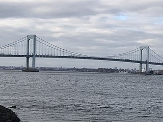
The Throgs Neck Bridge is a suspension bridge in New York City, carrying six lanes of Interstate 295 (I-295) over the East River where it meets the Long Island Sound. The bridge connects the Throggs Neck section of the Bronx with the Bay Terrace section of Queens.
Sunnyside and Sunny Side may refer to:
Interstate 495 (I-495), commonly known as the Long Island Expressway (LIE), is an auxiliary Interstate Highway in the U.S. state of New York. It is jointly maintained by the New York State Department of Transportation (NYSDOT), the New York City Department of Transportation (NYCDOT), MTA Bridges and Tunnels (MTAB&T), and the Port Authority of New York and New Jersey (PANYNJ).
Interstate 295 (I-295) is an Interstate Highway within New York City. Measuring 9.10 miles (14.6 km) in length, I-295 originates at Hillside Avenue in Queens, running north across Queens and over the tolled Throgs Neck Bridge, to Bruckner Interchange, a junction with I-95, I-278, I-678, and the Hutchinson River Parkway in the Bronx. From south to north, I-295 intersects the Grand Central Parkway, I-495, and the Cross Island Parkway in Queens before crossing the Throgs Neck Bridge and splitting with the I-695. In Queens, I-295 is also known as the Clearview Expressway.
New York State Route 878 (NY 878) is a state highway on Long Island and in New York City. The route exists in two sections, which both form the Nassau Expressway. NY 878's western terminus is the Belt Parkway and Conduit Avenue (NY 27) in Ozone Park, within southern Queens. Its southern terminus is immediately before the Village of Atlantic Beach, at the Atlantic Beach Bridge in Lawrence, within southwestern Nassau County. NY 878 is discontinuous between Farmers Boulevard in Queens and the town of Inwood in Nassau County. The two sections are connected to each other by Rockaway Boulevard and Rockaway Turnpike.
Interstate 78 (I-78) is a part of the Interstate Highway System that runs from Union Township, Lebanon County, Pennsylvania, to New York City. In the U.S. state of New York, I-78 extends 0.90 miles (1.45 km). The entirety of I-78 consists of the Holland Tunnel, which crosses under the Hudson River from New Jersey and ends at an exit rotary in Lower Manhattan. The tunnel and its approaches are maintained by the Port Authority of New York and New Jersey (PANYNJ).

Auburndale is an upper-middle-class neighborhood in the northern part of the New York City borough of Queens, between Bayside and Murray Hill.
New York State Route 24 (NY 24) is a 30.84-mile-long (49.63 km) east–west state highway on Long Island in the U.S. state of New York. The highway is split into two segments, with the longest and westernmost of the two extending 18.68 miles (30.06 km) from an interchange with Interstate 295 and NY 25 in the Queens Village section of the New York City borough of Queens to an intersection with NY 110 in East Farmingdale in the Suffolk County town of Babylon. The shorter eastern section, located in eastern Suffolk County, extends 12.16 miles (19.57 km) from an interchange with I-495 in Calverton to an intersection with County Route 80 (CR 80) in Hampton Bays.
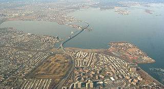
Bay Terrace is a neighborhood in the northeastern section of the New York City borough of Queens. It is often considered part of the larger area of Bayside. Bay Terrace overlooks the East River and the approaches to the Throgs Neck Bridge from the Clearview Expressway and Cross Island Parkway. It is bounded on the west by the Clearview Expressway, on the south by 26th and 28th Avenues, to the east by the Little Neck Bay, and to the north by the East River.

Cunningham Park is a 358-acre (1.4 km2) park in the New York City borough of Queens. The park lies between the Grand Central Parkway to the south and the Long Island Expressway, and is bifurcated by the Clearview Expressway. The park is operated by the New York City Department of Parks and Recreation.
The Queens Community Board 8 is a local government in the New York City borough of Queens, encompassing the neighborhoods of Briarwood, Cunningham Heights, Flushing South, Fresh Meadows, Hillcrest, Hilltop Village, Holliswood, Jamaica Estates, Jamaica Hills, Kew Gardens Hills, Pomonok, and Utopia. It is delimited by the Long Island Expressway to Hillside Avenue and from the Van Wyck Expressway to the Clearview Expressway.
The Queens Community Board 11 is a local government in the New York City borough of Queens, encompassing the neighborhoods of Bayside, Douglaston–Little Neck, Auburndale, East Flushing, Oakland Gardens and Hollis Hills. It is delimited by Utopia Parkway to the west, 26th Avenue and Little Neck Bay to the north, the Nassau County border to the east and Horace Harding Expressway, Clearview Expressway and Grand Central Parkway to the south.
The JFK Expressway is a short freeway connecting the Belt Parkway with John F. Kennedy International Airport in Queens, New York City. It interchanges with the Nassau Expressway near the former proposed south end of the Clearview Expressway. The roadway is the newest expressway in New York City, opened in December 1991.

Clearview Cinemas was a chain of movie theatres within the New York metropolitan area. Most of the Clearview Cinema locations were purchased by Bow Tie Cinemas in April 2013.
Clearview AI is an American facial recognition company, providing software to companies, law enforcement, universities, and individuals. The company's algorithm matches faces to a database of more than three billion images indexed from the Internet, including social media applications. Founded by Hoan Ton-That and Richard Schwartz, the company maintained a low profile until late 2019, when its usage by law enforcement was reported on. Multiple reports identified Clearview's association with far-right personas dating back to 2016, when the company claimed to sever ties with two employees.