Innes National Park is a protected area in the Australian state of South Australia located on the southwest tip of Yorke Peninsula about 300 kilometres (190 mi) west of the state capital of Adelaide. Known as Innes by many, the national park is a popular destination for camping, bushwalking, fishing, surfing and scuba diving.

Lincoln National Park is a protected area in the Australian state of South Australia located about 249 kilometres (155 mi) west of the state capital of Adelaide and about 9.5 kilometres (5.9 mi) south of the municipal seat of Port Lincoln. It consists of a mainland area on the Jussieu Peninsula on the south eastern tip of Eyre Peninsula and a number of nearby islands. The national park contains significant sites of natural, indigenous and early European heritage.

The Eyre Peninsula is a triangular peninsula in South Australia. It is bounded on the east by Spencer Gulf, the west by the Great Australian Bight, and the north by the Gawler Ranges.

The District Council of Lower Eyre Peninsula is a local government area located on Eyre Peninsula in South Australia. The district covers the southern tip of the peninsula, except for the small area taken up by the City of Port Lincoln.
The Whidbey Isles Conservation Park is a protected area in the Australian state of South Australia which consists of seven islands located west-southwest of Coffin Bay, lower Eyre Peninsula. The group, which includes the Four Hummocks group, Perforated Island, Price Island and Golden Island, supports breeding populations of seabirds and marine mammals. Colonies of the endangered Australian Sea-lion and protected New Zealand Fur-seal occur on some of these islands. The conservation park is classified as an IUCN Category Ia protected area.
The Avoid Bay Islands Conservation Park is a protected area in the Australian state of [[South Australia] occupying three islands located west-southwest of Coffin Bay of Eyre Peninsula. The group, which includes Black Rocks and Sudden Jerk Island, supports breeding populations of seabirds and marine mammals. Colonies of the endangered Australian Sea-lion and protected New Zealand Fur-seal occur on some of these islands. The conservation park is classified as an IUCN Category Ia protected area.ref name=CAPAD2016SASum/>
Rocky Island (North) Conservation Park is a protected area in the Australian state of South Australia associated with North Rocky Island which is located off the west coast of Eyre Peninsula in South Australia about 43 kilometres north northwest of Coffin Bay. The conservation park which had been declared as Fauna Conservation Reserve in March 1967, was re-proclaimed in 1972 under the National Parks and Wildlife Act 1972 to ‘conserve seal haulout areas and associated island habitat.’ The conservation park is classified as an International Union for Conservation of Nature (IUCN) Category Ia protected area.
Rocky Island (South) Conservation Park is a protected area in the Australian state of South Australia associated with Rocky Island which is located off the west coast of Eyre Peninsula about 72 kilometres west-southwest of Coffin Bay. The conservation park was proclaimed in 1972 under the National Parks and Wildlife Act 1972 to ‘conserve New Zealand fur seal breeding areas and associated island habitat’. The conservation park is classified as an IUCN Category Ia protected area.

Kellidie Bay Conservation Park is a protected area in the Australian state of South Australia, located on the west coast of Eyre Peninsula immediately east of the town centre in Coffin Bay and immediately adjoining the south coast of Kellidie Bay in the localities of Coffin Bay, Kellidie Bay and Wangary.
Mount Dutton Bay Conservation Park is a protected area located on the west coast of Eyre Peninsula in South Australia on islands located on waters in the sector between the north west to the east of the town of Coffin Bay. The conservation park consists of a number of islands located in the following bays subsidiary to Coffin Bay - Port Douglas, Mount Dutton Bay and Kellidie Bay. Three of the islands are located in Port Douglas, being The Brothers and an unnamed group immediately west of Horse Peninsula and Rabbit Island immediately west of Coffin Bay township. Another island is located at the north end of Mount Dutton Bay, while Goat Island immediately north of Coffin Bay township in the channel connecting Port Douglas to Kellidie Bay. The constituent parts of the conservation park first received protection as Fauna Reserves under the Fauna Conservation Act 1964 during the 1960s. The conservation park is classified as an IUCN Category Ia protected area.

Greenly Island Conservation Park is a protected area associated with Greenly Island located off the west coast of Eyre Peninsula in South Australia about 70 kilometres west of Coffin Bay. It was declared in 1972 under the National Parks and Wildlife Act 1972 ‘to protect the island’s delicate ecology and Australian Sea-lion and New Zealand Fur-seal haul-out areas’ and continuing protected area status for the island which was first declared in 1919. The conservation park is classified as an IUCN Category Ia protected area.
Lincoln Conservation Park is a protected area in the Australian state of South Australia located in the Eyre Peninsula in the gazetted locality of Tulka on land in the Section 490 in the cadastral unit of Hundred of Lincoln about 15 kilometres south west of Port Lincoln.

Coffin Bay Peninsula is a peninsula located at the south west end of Eyre Peninsula in South Australia. It extends in a north westerly direction from its connection to Eyre Peninsula and is bounded by Coffin Bay, Port Douglas and Yangie Bay to the north, the Great Australian Bight to the west and Avoid Bay to the south. Its extremities are Point St Isaac in the north, Point Whidbey in the south west, Point Longnose in the north east and Point Avoid in the south east. Its name is derived from Coffin Bay which was named by Matthew Flinders on 16 February 1802, after Sir Isaac Coffin, 1st Baronet. While parts of its surface have been cleared and used for agricultural purposes in the past, it is currently occupied by the protected area, the Coffin Bay National Park.
Point Whidbey is a headland located at the southern western extremity of both Coffin Bay Peninsula and Avoid Bay on the west coast of Eyre Peninsula in South Australia about 34 kilometres west of the town of Coffin Bay. It was described in 2012 as being “fronted by low cliffs and rises to a round hill, 62 metres high, about 1 mile inland.” It is one of the features named by Matthew Flinders in February 1802 after his friend and Royal Navy officer, Joseph Whidbey. The point is currently located within the boundaries of the protected area, the Coffin Bay National Park.
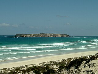
Point Avoid is a headland located at the south eastern extremity of both Coffin Bay Peninsula and Avoid Bay on the west coast of Eyre Peninsula in South Australia about 15 kilometres south west of the town of Coffin Bay. It was described in 2017 as being “fronted on all of its seaward sides by limestone cliffs, about 46 metres high, which change abruptly to sand hills E of its S(outhern) extremity.” It was named by Matthew Flinders on 17 February 1802 to acknowledge the navigational hazards present around its shores. The point is currently located within the boundaries of the protected area, the Coffin Bay National Park.
Little Douglas is a locality in the Australian state of South Australia located on the Eyre Peninsula in the state’s west overlooking the body of water known as Coffin Bay about 293 kilometres (182 mi) west of the state capital of Adelaide and about 42 kilometres (26 mi) south-west of the municipal seat of Cummins.
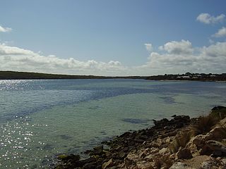
Kellidie Bay is a locality in the Australian state of South Australia located on the Eyre Peninsula in the state’s west overlooking parts of the body of water known as Coffin Bay about 290 kilometres (180 mi) west of the state capital of Adelaide and about 42 kilometres (26 mi) south-west of the municipal seat of Cummins.
This page is based on this
Wikipedia article Text is available under the
CC BY-SA 4.0 license; additional terms may apply.
Images, videos and audio are available under their respective licenses.