The Stour Estuary is a nature reserve in Essex, England, east of Colchester on the estuary of the River Stour, managed by the Royal Society for the Protection of Birds (RSPB).
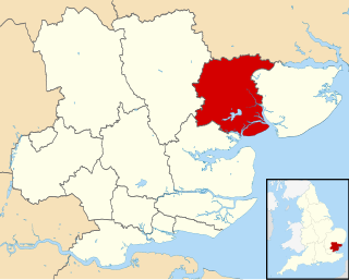
The Borough of Colchester is a local government district and borough in Essex, England, named after its main town, Colchester. The borough covers an area of 125 square miles (320 km2) and stretches from Dedham Vale on the Suffolk border in the north to Mersea Island on the Colne Estuary in the south.

Colchester Castle in Colchester, Essex, England, is an example of a largely complete Norman castle. It is a Grade I listed building.
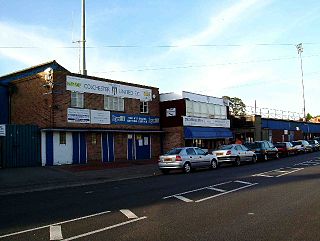
Layer Road was a Football League stadium in Colchester, England. It was only used for football matches and was the home ground of Colchester United before being replaced by the Colchester Community Stadium. The stadium held 6,320 spectators and was built in 1907, originally for use by Colchester Town Football Club. Layer Road has often had up to 17,000 packed into the ground, when Colchester had been on a good FA Cup run, before the capacity was reduced to 6,320. The record attendance at Layer Road is 19,072 for an FA Cup fixture against Reading in November 1948, a match that was abandoned. The ground was also used to host Sudbury Town's FA Cup match against Brentford in 1996, as their Priory Stadium was deemed unfit. One of the unusual features of the ground was at the Layer Road End, where the back of the goal and the netting actually cut back into the stand.

The A120 is an important trunk road in the East of England. It follows the course of Stane Street, a Roman road from Standon, Hertfordshire at its western terminus to Colchester. From Colchester the A120 leads roughly east to the Essex port of Harwich.

Hatfield Broad Oak Priory, or Hatfield Regis Priory, is a former Benedictine priory in Hatfield Broad Oak, Essex, England. Founded by 1139, it was dissolved in 1536 as part of Henry VIII's dissolution of the monasteries.

Colchester High School is a coeducational independent school located in Colchester in Essex, England. The school is owned and operated by the Cognita Group. Colchester High is the only coeducational independent school in Colchester to offer secondary education.

Thomas Lord Audley School is a mixed 11-16 secondary school with academy status for 800 pupils, to the south of Colchester, Essex. It serves a wide catchment area, taking students from the edge of Colchester, small villages and the community of Mersea Island. The school building is modern, with single, double and three-storey accommodation with hard play areas and a playing field. There are seven science laboratories and six technology Suites. The PE facilities include a sports hall, fitness suite and gym. As of 2009, the school also has new drama and music facilities and a new suite of modern language rooms.

Fordstreet or Ford Street is a village on the A1124 road, in the civil parish of Aldham in the Colchester district in Essex, England. It is located on the River Colne and is near the large town of Colchester. Artist Damon Albarn lived there as a child.

Hollytrees Museum is a free to visit, publicly owned museum in the centre of Colchester and close to Colchester Castle. It is situated in an eighteenth-century house ("Hollytrees"), which was used as a private residence until 1929, when it became a museum.
Lossenham Friary was a Carmelite friary in the Weald of Kent in southeast England.

Boston Friary refers to any one of four friaries that existed in Boston, Lincolnshire, England.

In London, the Greyfriars was a Conventual Franciscan friary that existed from 1225 to 1538 on a site at the North-West of the City of London by Newgate in the parish of St Nicholas in the Shambles. It was the second Franciscan religious house to be founded in the country. The establishment included a conventual church that was one of the largest in London; a studium or regional university; and an extensive library of logical and theological texts. It was an important intellectual centre in the early fourteenth century, rivaled only by Oxford University in status. Members of the community at that time included William of Ockham, Walter Chatton and Adam Wodeham. It flourished in the fourteenth and fifteenth century, but was dissolved in 1538 at the instigation of Henry VIII as part of the dissolution of the monasteries. Christ's Hospital was founded in the old conventual buildings, and the church was rebuilt completely by Christopher Wren as Christ Church after the original church was almost completely destroyed in the Great Fire of London. The building currently standing on the site, designed by Arup, is currently occupied by Merrill Lynch International.

Friary Park is a nine hectare formal Edwardian park in Friern Barnet in the London Borough of Barnet.
Colchester Corporation Tramways served the town of Colchester in Essex from 28 July 1904 until 8 December 1929.

Bull Neadow is a 1.4 hectare Local Nature Reserve in Colchester in Essex. It is owned and managed by Colchester Borough Council.

Salary Brook Local Nature Reserve is a 17.1 hectare Local Nature Reserve covering a stretch of Salary Brook and its banks on the south-east outskirts of Colchester in Essex. It is owned and managed by Colchester Borough Council.

Welsh Wood is a 3.2 hectare Local Nature Reserve in Colchester in Essex. It is owned and managed by Colchester Borough Council.

Spring Lane Meadows or Lexden Springs is a 2 hectare Local Nature Reserve in Lexden, a suburb of Colchester in Essex. It is owned and managed by Colchester Borough Council.

Hilly Fields is a 37.5 hectare Local Nature Reserve in Colchester, Essex. It is owned and managed by Colchester Borough Council. It is also a scheduled monument as it is in a late Iron Age site and Roman Camulodunum.


