
Broadway is a road in the U.S. state of New York. Broadway runs from State Street at Bowling Green for 13 mi (21 km) through the borough of Manhattan and 2 mi (3.2 km) through the Bronx, exiting north from the city to run an additional 18 mi (29 km) through the municipalities of Yonkers, Hastings-On-Hudson, Dobbs Ferry, Irvington, and Tarrytown, and terminating north of Sleepy Hollow in Westchester County.
Many closings and cancellations followed the September 11, 2001 attacks, including major landmarks, buildings, restrictions on access to Lower Manhattan, and postponement or cancellation of major sporting and other events. Landmarks were closed primarily because of fears that they may be attacked. At some places, streets leading up to the institutions were also closed. When they reopened, there was heightened security. Many states declared a state of emergency.

Dupont Circle is a traffic circle, park, neighborhood, and historic district in Northwest Washington, D.C. The Dupont Circle neighborhood is bounded approximately by 16th Street NW to the east, 22nd Street NW to the west, M Street NW to the south, and Florida Avenue NW to the north. Much of the neighborhood is listed on the National Register of Historic Places. However, the local government Advisory Neighborhood Commission and the Dupont Circle Historic District have slightly different boundaries.

Washington Union Station is a major train station, transportation hub, and leisure destination in Washington, D.C. Opened in 1907, it is Amtrak's headquarters and the railroad's second-busiest station with annual ridership of just under 5 million and the ninth-busiest in overall passengers served in the United States. The station is the southern terminus of the Northeast Corridor, an electrified rail line extending north through major cities including Baltimore, Philadelphia, New York City, and Boston and the busiest passenger rail line in the nation.

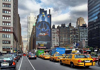
Columbus Circle is a traffic circle and heavily trafficked intersection in the New York City borough of Manhattan, located at the intersection of Eighth Avenue, Broadway, Central Park South, and Central Park West, at the southwest corner of Central Park. The circle is the point from which official highway distances from New York City are measured, as well as the center of the 25 miles (40 km) restricted-travel area for C-2 visa holders.
The IND Eighth Avenue Line is a rapid transit line in New York City, United States, and is part of the B Division of the New York City Subway. Opened in 1932, it was the first line of the Independent Subway System (IND), and the Eighth Avenue Subway name was also applied by New Yorkers to the entire IND system.
59th Street station may refer to:

The D Sixth Avenue Express is a rapid transit service in the B Division of the New York City Subway. Its route emblem, or "bullet", is colored orange, since it uses the IND Sixth Avenue Line in Manhattan.
Eighth Avenue is a major north–south avenue on the west side of Manhattan in New York City, carrying northbound traffic below 59th Street. While the avenue has different names at different points in Manhattan, it is actually one continuous stretch of road.
Ninth Avenue, known as Columbus Avenue between West 59th and 110th Streets, is a thoroughfare on the West Side of Manhattan in New York City. Traffic runs downtown (southbound) along the full stretch from Chelsea to the Upper West Side, except for the lowermost three blocks where traffic runs northbound carrying traffic from Greenwich Street.

Tenth Avenue, known as Amsterdam Avenue between 59th Street and 193rd Street, is a north-south thoroughfare on the West Side of Manhattan in New York City. It carries uptown (northbound) traffic as far as West 110th Street, after which it continues as a two-way street.

110th Street is a street in the New York City borough of Manhattan. It is commonly known as the boundary between Harlem and Central Park, along which it is known as Central Park North. In the west, between Central Park West/Frederick Douglass Boulevard and Riverside Drive, it is co-signed as Cathedral Parkway.

59th Street–Columbus Circle is a New York City Subway station complex shared by the IRT Broadway–Seventh Avenue Line and the IND Eighth Avenue Line. It is the eighth-busiest station complex in the system. It is located at Columbus Circle in Manhattan, where 59th Street, Broadway and Eighth Avenue intersect, and serves Central Park, the Upper West Side, Hell's Kitchen, and Midtown Manhattan. The station is served by the 1, A, and D trains at all times; the C train at all times except late nights; the B train during weekdays until 11:00 p.m.; and the 2 train during late nights.

125th Street is an express station on the IND Eighth Avenue Line of the New York City Subway. Located at the intersection of 125th Street and St. Nicholas Avenue in the Harlem neighborhood of Manhattan, it is served by the A and D trains at all times, by the C train at all times except late nights, and by the B train on weekdays.

Fifth Avenue/53rd Street is a station on the IND Queens Boulevard Line of the New York City Subway. Located at the intersection of Fifth Avenue and 53rd Street in Manhattan, it is served by the E train at all times and the M train weekdays except late nights.
59th Street is a crosstown street in the New York City borough of Manhattan, running from York Avenue/Sutton Place on the East Side of Manhattan to the West Side Highway on the West Side. The three-block portion between Columbus Circle and Grand Army Plaza is known as Central Park South, since it forms the southern border of Central Park. The street is mostly continuous, except between Ninth Avenue/Columbus Avenue and Columbus Circle, where the Time Warner Center is located. While Central Park South is a bidirectional street, most of 59th Street carries one-way traffic.

The M5 and M55 bus routes constitute a public transit corridor in Manhattan, New York City, running along the Fifth / Sixth Avenues / Riverside Drive Line as well as the southern portion of the Broadway Line after the discontinuation of the M6. The routes primarily run along Broadway, Fifth and Sixth Avenues, and Riverside Drive from South Ferry, Lower Manhattan to Washington Heights. The M5 covers the northern portion of the route north of 31st Street, while the M55 operates along the southern portion of the route south of 44th Street. The two routes overlap in Midtown Manhattan. The portion along Broadway south of East 8th Street was originally a streetcar line.

The M12 bus route constitutes a public transit line in Manhattan, New York City. The M12 operates between Columbus Circle and Abingdon Square, serving Manhattan's West Side. It uses 11th and 12th Avenues between 14th and 57th Streets. It was introduced in 2014 to provide better service to the far west side.