Related Research Articles

A geographic information system (GIS) consists of integrated computer hardware and software that store, manage, analyze, edit, output, and visualize geographic data. Much of this often happens within a spatial database, however, this is not essential to meet the definition of a GIS. In a broader sense, one may consider such a system also to include human users and support staff, procedures and workflows, the body of knowledge of relevant concepts and methods, and institutional organizations.

Environmental Systems Research Institute, Inc., doing business as Esri, is an American multinational geographic information system (GIS) software company headquartered in Redlands, California. It is best known for its ArcGIS products. With a 40% market share, Esri is the world's leading supplier of GIS software, web GIS and geodatabase management applications.

The National Geospatial-Intelligence Agency (NGA) is a combat support agency within the United States Department of Defense whose primary mission is collecting, analyzing, and distributing geospatial intelligence (GEOINT) in support of national security. Initially known as the National Imagery and Mapping Agency (NIMA) from 1996 to 2003, it is a member of the United States Intelligence Community.
A GIS file format is a standard for encoding geographical information into a computer file, as a specialized type of file format for use in geographic information systems (GIS) and other geospatial applications. Since the 1970s, dozens of formats have been created based on various data models for various purposes. They have been created by government mapping agencies, GIS software vendors, standards bodies such as the Open Geospatial Consortium, informal user communities, and even individual developers.
A GIS software program is a computer program to support the use of a geographic information system, providing the ability to create, store, manage, query, analyze, and visualize geographic data, that is, data representing phenomena for which location is important. The GIS software industry encompasses a broad range of commercial and open-source products that provide some or all of these capabilities within various information technology architectures.
A Web Map Service (WMS) is a standard protocol developed by the Open Geospatial Consortium in 1999 for serving georeferenced map images over the Internet. These images are typically produced by a map server from data provided by a GIS database.
ArcSDE is a server-software sub-system that aims to enable the usage of Relational Database Management Systems for spatial data. The spatial data may then be used as part of a geodatabase.

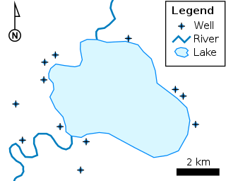
The shapefile format is a geospatial vector data format for geographic information system (GIS) software. It is developed and regulated by Esri as a mostly open specification for data interoperability among Esri and other GIS software products. The shapefile format can spatially describe vector features: points, lines, and polygons, representing, for example, water wells, rivers, and lakes. Each item usually has attributes that describe it, such as name or temperature.

ArcGIS is a family of client, server and online geographic information system (GIS) software developed and maintained by Esri.

Java Unified Mapping Program (JUMP) is a Java based vector and raster GIS and programming framework. Current development continues under the OpenJUMP name.

The Geospatial Data Abstraction Library (GDAL) is a computer software library for reading and writing raster and vector geospatial data formats, and is released under the permissive X/MIT style free software license by the Open Source Geospatial Foundation. As a library, it presents a single abstract data model to the calling application for all supported formats. It may also be built with a variety of useful command line interface utilities for data translation and processing. Projections and transformations are supported by the PROJ library.
ArcGIS Server is the core server geographic information system (GIS) software made by Esri. ArcGIS Server is used for creating and managing GIS Web services, applications, and data. ArcGIS Server is typically deployed on-premises within the organization’s service-oriented architecture (SOA) or off-premises in a cloud computing environment.
ArcMap is the former main component of Esri's ArcGIS suite of geospatial processing programs. Used primarily to view, edit, create, and analyze geospatial data. ArcMap allows the user to explore data within a data set, symbolize features accordingly, and create maps. This is done through two distinct sections of the program, the table of contents and the data frame. In October 2020, it was announced that there are no plans to release 10.9 in 2021, and that ArcMap would no longer be supported after March 1, 2026. Esri is encouraging their users to transition to ArcGIS Pro.
Distributed GIS refers to GI Systems that do not have all of the system components in the same physical location. This could be the processing, the database, the rendering or the user interface. It represents a special case of distributed computing, with examples of distributed systems including Internet GIS, Web GIS, and Mobile GIS. Distribution of resources provides corporate and enterprise-based models for GIS. Distributed GIS permits a shared services model, including data fusion based on Open Geospatial Consortium (OGC) web services. Distributed GIS technology enables modern online mapping systems, Location-based services (LBS), web-based GIS and numerous map-enabled applications. Other applications include transportation, logistics, utilities, farm / agricultural information systems, real-time environmental information systems and the analysis of the movement of people. In terms of data, the concept has been extended to include volunteered geographical information. Distributed processing allows improvements to the performance of spatial analysis through the use of techniques such as parallel processing.
Geographic information systems (GIS) play a constantly evolving role in geospatial intelligence (GEOINT) and United States national security. These technologies allow a user to efficiently manage, analyze, and produce geospatial data, to combine GEOINT with other forms of intelligence collection, and to perform highly developed analysis and visual production of geospatial data. Therefore, GIS produces up-to-date and more reliable GEOINT to reduce uncertainty for a decisionmaker. Since GIS programs are Web-enabled, a user can constantly work with a decision maker to solve their GEOINT and national security related problems from anywhere in the world. There are many types of GIS software used in GEOINT and national security, such as Google Earth, ERDAS IMAGINE, GeoNetwork opensource, and Esri ArcGIS.
Geosoft Incorporated is a software development and services company headquartered in Toronto, Canada. The company provides geophysical and geological software and geospatial server technology for professional geoscientists involved in natural resource exploration and related earth science disciplines.

CARTO is a software as a service (SaaS) spatial analysis platform that provides GIS, web mapping, data visualization, spatial analytics, and spatial data science features. The company is positioned as a Location Intelligence platform due to its tools for geospatial data analysis and visualization that do not require advanced GIS or development experience. As a cloud-native platform, CARTO runs natively on cloud data warehouse platforms overcoming any previous limits on data scale for spatial workloads.

Android Team Awareness Kit (ATAK) is an Android smartphone geospatial infrastructure and military situation awareness app. It allows for precision targeting, surrounding land formation intelligence, situational awareness, navigation, and data sharing. This Android app is a part of the larger TAK family of products. ATAK has a plugin architecture which allows developers to add functionality. This extensible plugin architecture that allows enhanced capabilities for specific mission sets.

FME, also known as Feature Manipulation Engine, is a geospatial extract, transformation and load software platform developed and maintained by Safe Software of British Columbia, Canada. FME was first released in 1996, and evolved out of a successful bid by the founders of Safe Software, Don Murray and Dale Lutz, for a Canadian Government contract to monitor logging activities.
A Geodatabase is a proprietary GIS file format developed in the late 1990s by Esri to represent, store, and organize spatial datasets within a geographic information system. A geodatabase is both a logical data model and the physical implementation of that logical model in several proprietary file formats released during the 2000s. The geodatabase design is based on the spatial database model for storing spatial data in relational and object-relational databases. Given the dominance of Esri in the GIS industry, the term "geodatabase" is used by some as a generic trademark for any spatial database, regardless of platform or design.