Continental Stress Class

Last updated

Continental Stress Class is a method of describing the landscape health of biogeographic regions in Australia. There are six Continental Stress Classes with Class 1 containing the most stressed regions and Class 6 the least stressed and therefore most healthy. The classification takes into account indicators of landscape health such as the extent, condition, connectivity, and rate of clearing of native vegetation; changes to soil and hydrological conditions; the presence of feral plants and animals; the presence of threatened species and ecological communities; and threats such as dryland salinity; and fire regime.

Biogeography The study of the distribution of species and ecosystems in geographic space and through geological time

Biogeography is the study of the distribution of species and ecosystems in geographic space and through geological time. Organisms and biological communities often vary in a regular fashion along geographic gradients of latitude, elevation, isolation and habitat area. Phytogeography is the branch of biogeography that studies the distribution of plants. Zoogeography is the branch that studies distribution of animals.

Australia Country in Oceania

Australia, officially the Commonwealth of Australia, is a sovereign country comprising the mainland of the Australian continent, the island of Tasmania, and numerous smaller islands. It is the largest country in Oceania and the world's sixth-largest country by total area. The neighbouring countries are Papua New Guinea, Indonesia, and East Timor to the north; the Solomon Islands and Vanuatu to the north-east; and New Zealand to the south-east. The population of 26 million is highly urbanised and heavily concentrated on the eastern seaboard. Australia's capital is Canberra, and its largest city is Sydney. The country's other major metropolitan areas are Melbourne, Brisbane, Perth, and Adelaide.

Continental Stress Classes were first introduced by Gethin Morgan in 2001, in the report Landscape Health In Australia: A rapid assessment of the relative condition of Australia's bioregions and subregions. [1] Morgan gave a class to each of the Interim Biogeographic Regionalisation for Australia (IBRA) subregions, as follows:

Interim Biogeographic Regionalisation for Australia biogeographic regionalisation of Australia developed by the Australian Government

The Interim Biogeographic Regionalisation for Australia (IBRA) is a biogeographic regionalisation of Australia developed by the Australian Government's Department of Sustainability, Environment, Water, Population and Communities. It was developed for use as a planning tool, for example for the establishment of a National Reserve System.

Avon Wheatbelt Bioregion

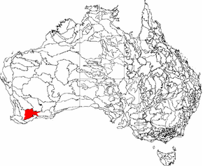
The Avon Wheatbelt is an Australian bioregion in Western Australia and part of the larger Southwest Australia savanna ecoregion.

Victoria (Australia) State in Australia

Victoria is a state in south-eastern Australia. Victoria is Australia's smallest mainland state and its second-most populous state overall, making it the most densely populated state overall. Most of its population lives concentrated in the area surrounding Port Phillip Bay, which includes the metropolitan area of its state capital and largest city, Melbourne, Australia's second-largest city. Victoria is bordered by Bass Strait and Tasmania to the south, New South Wales to the north, the Tasman Sea, to the east, and South Australia to the west.

The classification is now used by a range of federal and state government agencies in Australia.

Related Research Articles

Nearctic realm one of the eight terrestrial ecozones constituting the Earths land surface

The Nearctic is one of the eight biogeographic realms constituting the Earth's land surface.

A bioregion is an ecologically and geographically defined area that is smaller than an ecozone, but larger than an ecoregion or an ecosystem, in the World Wildlife Fund classification scheme. There is also an attempt to use the term in a rank-less generalist sense, similar to the terms "biogeographic area" or "biogeographic unit".

Wellesley Islands locality in Queensland, Australia

The Wellesley Islands are a group of islands off the coast of north Queensland, Australia, in the Gulf of Carpentaria. They were named by Matthew Flinders in honour of Richard Wellesley, 1st Marquess Wellesley. The largest island in the group is Mornington Island. Two small islands in the group form the Manowar and Rocky Islands Important Bird Area because of their importance for breeding seabirds. The South Wellesley Islands and the Forsyth Islands are in the same area and all are the local government area of the Shire of Mornington.

The Natural Heritage Trust (NHT) was set up by the Australian Government in 1997 to help restore and conserve Australia's environment and natural resources. Since then, considerable numbers of community groups and organisations have received funding for environmental and natural resource management projects.

The South West Slopes is a region predominantly in New South Wales, Australia. It covers the lower inland slopes of the Great Dividing Range extending from north of Cowra through southern NSW into western Victoria. More than 90% of the region is in the state of New South Wales and it occupies about 10% of that state.

Esperance Plains biogeographic region of Australia

Esperance Plains, also known as Eyre Botanical District, is a biogeographic region in southern Western Australia on the south coast between the Avon Wheatbelt and Hampton regions, and bordered to the north by the Mallee region. It is a plain punctuated by granite and quartz outcrops and ranges, with a semi-arid Mediterranean climate and vegetation consisting mostly of mallee-heath and proteaceous scrub. About half of the region has been cleared for intensive agriculture. Recognised as a bioregion under the Interim Biogeographic Regionalisation for Australia (IBRA), it was first defined by John Stanley Beard in 1980.

Western Mallee

Western Mallee is an Interim Biogeographic Regionalisation for Australia (IBRA) subregion in southern Western Australia. It is a sparsely populated subregion with an area of about 47,000 square kilometres, roughly centred on the town of Newdegate. Largely cleared for intensive agriculture, it still retains patches of native vegetation, but these are under environmental stress from threats such as rising salinity, and are poorly managed.

Eastern Mallee

Eastern Mallee is an Interim Biogeographic Regionalisation for Australia (IBRA) subregion in southern Western Australia.

In the state of New South Wales, Australia, there are many areas which are commonly known by regional names. Regions are areas that share similar characteristics. These characteristics may be natural such as the Murray River, the coastline, or the Snowy Mountains. Alternatively, the characteristics may be cultural, such as a viticulture land use. New South Wales is divided by numerous regional boundaries, based on different characteristics. In many cases boundaries defined by different agencies are coterminous.

The Integrated Marine and Coastal Regionalisation of Australia (IMCRA), formerly the Interim Marine and Coastal Regionalisation for Australia, is a biogeographic regionalisation of the oceanic waters of Australia's Exclusive Economic Zone (EEZ). As of 2008, the most recent version is IMCRA Version 4.0.

Einasleigh Uplands

The Einasleigh Uplands is an interim Australian bioregion, with vegetation consisting of savanna and woodland located on a large plateau in inland Queensland, Australia.

In the Australian state of Tasmania, there are many areas which are commonly known by regional names. Regions are areas that share similar characteristics. These characteristics may be natural such as the Furneaux Islands, the coastline, or the Central Highlands. Alternatively, the characteristics may be cultural, such as a viticulture land use. Tasmania is divided by numerous regional boundaries, based on different characteristics. In many cases boundaries defined by different government agencies are coterminous and are often cited by the Australian and local media that tend to distinguish between North West, West Coast, Southern, and East Coast.

South Eastern Highlands Region in Australia

The South Eastern Highlands is an interim Australian bioregion in eastern Australia, that spans parts of the states and territories of New South Wales, the Australian Capital Territory, and Victoria. The bioregion comprises 8,375,961 hectares and is approximately 3,860 kilometres (2,400 mi) long. The Australian Alps as well as the South West Slopes bound the region from the south and west; and to the northeast, the Sydney Basin bioregion, as well as the bioregion of the South East Corner, to the east.

In South Australia, one of the states of Australia, there are many areas which are commonly known by regional names. Regions are areas that share similar characteristics. These characteristics may be natural such as the Murray River, the coastline, desert or mountains. Alternatively, the characteristics may be cultural, such as common land use. South Australia is divided by numerous sets of regional boundaries, based on different characteristics. In many cases boundaries defined by different agencies are coterminous.

Cape York Peninsula (biogeographic region) Region in Queensland, Australia

Cape York Peninsula, an interim Australian bioregion, is located in Queensland.

Central Mackay Coast Region in Queensland, Australia

Central Mackay Coast, an interim Australian bioregion, is located in Queensland, and comprises 1,464,208 hectares.

Marine ecoregions of the South African exclusive economic zone Geographical regions of similar ecological characteristics

The marine ecoregions of the South African exclusive economic zone are a set of geographically delineated regions of similar ecological characteristics on a fairly broad scale, covering the exclusive economic zone along the South African coast. There were originally five inshore bioregions over the continental shelf and four offshore bioregions covering the continental slope and abyssal regions.

Biogeographic regions of Europe

The biogeographic regions of Europe are biogeographic regions defined by the European Environment Agency. They were initially limited to the European Union member states, but later extended to cover all of Europe west of the Urals, including all of Turkey. The map of biogeographic regions is deliberately simplified and ignores local anomalies. It is intended primarily as a framework for coordinating and reporting overall results of conservation efforts.

References

  1. Morgan, Gethin (2001). "Landscape Health In Australia: A rapid assessment of the relative condition of Australia's bioregions and subregions". Environment Australia and National Land and Water Resources Audit. Archived from the original on June 29, 2004. Retrieved 2007-02-23.