
AlleghanyCounty is a county located in the U.S. state of North Carolina. As of the 2010 census, the population was 11,155. Its county seat is Sparta.

Camp Verde is a town in Yavapai County, Arizona, United States. As of the 2010 census, the population of the town is 10,873.

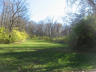
Denning is an isolated town in Ulster County, New York, USA. The population was 551 at the 2010 census. The town is named after an early landowner, William Denning. Denning is located in the western part of the county, deep inside the Catskill Mountains. The location of the town in the Catskill State Park accounts in part for its low population.

Whitewater State Park is a state park of Minnesota, United States, preserving a stretch of the Whitewater River surrounded by rocky bluffs. It is located in Winona County in the southeastern blufflands area of the state. The 2,700-acre (11 km2) park features scenic overlooks and trout fishing in the spring-fed Whitewater River and Trout Run Creek. It has about 300,000 visitors annually, and is located 7 miles (11 km) north of St. Charles on Minnesota State Highway 74, which runs through the park.

Courthouse and Jail Rocks are two rock formations located near Bridgeport in the Nebraska Panhandle.

Cumberland Mountain State Park is a state park in Cumberland County, Tennessee, in the southeastern United States. The park consists of 1,720 acres (7.0 km2) situated around Byrd Lake, a man-made lake created by the impoundment of Byrd Creek in the 1930s. The park is set amidst an environmental microcosm of the Cumberland Plateau and provides numerous recreational activities, including an 18-hole Bear Trace golf course.

Ward Charcoal Ovens State Historic Park is an area designated for historic preservation and public recreation located 20 miles (32 km) south of the town of Ely in White Pine County, Nevada. The 700-acre (280 ha) state park protects beehive-shaped charcoal ovens constructed in the latter half of the 19th century.

Palisades State Park is a state park of South Dakota, USA, featuring cliffs and rock formations eroded out of pink Sioux Quartzite. The park is located just south of Garretson, 10 miles (16 km) off Interstate 90. At only 157 acres (64 ha), it is South Dakota's second-smallest state park.
The Benham Mound is a Native American mound in the southwestern part of the U.S. state of Ohio. Located in modern Amberley Village in Hamilton County, the mound is an archaeological site.

The Elkins Coal and Coke Company Historic District is a historic industrial site near the crossroads village of Bretz in Preston County, West Virginia. It is the site of the last major coke manufacturing facility to use beehive ovens, and was a major industrial site in northern West Virginia in the first half of the 20th century. Surviving elements include a row of 140 beehive ovens. The site was declared a National Historic Landmark in 1983.

Gainestown is an unincorporated community on the Alabama River in Clarke County, Alabama, United States. It was named for George Strother Gaines. Gaines established an Indian trading post here in 1809.

Desolation Canyon is a remote canyon on the Green River in the eastern Utah, United States that is listed on the National Register of Historic Places (NRHP). It is said to be one of the most remote areas in the lower 48.

The Dunlap coke ovens are the remnants of a coke production facility near Dunlap, in the U.S. state of Tennessee. Built in the early 1900s, the facility consists of five batteries of 268 beehive ovens, which operated under various companies until the early 1920s. The ovens are now listed on the National Register of Historic Places, and are maintained by the Sequatchie Valley Historical Society as part of Dunlap Coke Ovens Park.

Italian Community Bake Oven is a historic community bake oven located at Little Falls in Herkimer County, New York. It was built about 1891 and is abandoned. The utilitarian structure consists of a large rectangle of stone masonry outer walls enclosing the brick bake oven. The dimensions are approximately 16 feet wide, 20 feet deep, and 6 feet high. It was built to furnish large quantities of bread for Italian immigrant railroad workers in a work camp during 1891–1893.

The Bullskin Creek Site is an archaeological site in the southwestern portion of the U.S. state of Ohio. Located near Felicity in Clermont County, the site appears to have been a base camp for nomads during the Late Archaic period. The site comprises three loci: two significant areas of various debris and a large midden that underlies everything else. From these components, which cover an area of approximately 400 feet (120 m) by 600 feet (180 m), collectors and archaeologists have recovered hundreds of artifacts, including stone tools, weapons, and bone tools. Because the site is located in a farm field, it has frequently been cultivated, and the plow has brought at least five burials to the surface from a cemetery on the edge of the site. Among the types of features found at the site are ovens, trash pits, and postmolds. Bodies at the site were generally adorned with red ochre and buried in a flexed position.

Jackson-Washington State Forest is a state forest in Jackson and Washington Counties, Indiana, near the town of Brownstown. The forest includes over 18,000 acres (7,300 ha), most of which was bought by the state in the 1930s and 1950s. Jackson-Washington State Forest offers camping, fishing, hunting, archery, and trails for hiking, horseback riding, and cycling.

Clover Creek is an unincorporated community in Highland County, Virginia, United States. Clover Creek is located 10 miles (16 km) south-southeast of Monterey, Virginia on State Route 678. The community is situated in the Bullpasture Valley along the path of the Bullpasture River. Beginning in 1897 with a decision by the United States Board on Geographic Names, the community was officially referred to as the single-word "Clovercreek"; however, in 1970, the board modified the community's name to the current two-word "Clover Creek". During the French and Indian War, a British fort named Fort George was built near Clover Creek in 1754 consisting of a wooden stockade 90 feet (27 m) square. The fort was never directly attacked, though arrows were at one point launched against the fort from a distance leaving no damage. George Washington may have visited the fort while traveling in the area, marking the only time Washington visited the region which is now known as Highland County.

Howard's Covered Bridge is a historic covered bridge outside of Smithonia, Georgia in Oglethorpe County, Georgia. It was added to the National Register of Historic Places on July 1, 1975. The bridge is located 3 miles southeast of Smithonia on SR S2164. The bridge was built in 1905 in a Town lattice design and is 168 feet long. The span travels over Big Clouds Creek. The site is marked by a historical marker posted by the Georgia Historical Society. The bridge was named for the pioneer family that settled in the area in the late 1700s. It was built with convict labor and is fastened with wooden trunnels. The timber used was transported on the Smith and Dunlap Railroad, connecting James Monroe Smith 's farm with the Georgia Railroad at Dunlap, Georgia.

The Osage Creek Bridge is a historic bridge in southern Benton County, Arkansas. The bridge formerly carried County Road 71 across Osage Creek, about 4.5 miles (7.2 km) north of Tontitown, but it has been closed. It is a single-span iron Pratt through truss structure, with a span of 124 feet (38 m), resting on concrete abutments. It has a lattice guardrail on one side, a feature that rarely survives on bridges of this type. The bridge was built in 1911 by an unknown builder, and is one of about 60 Pratt truss bridges in the state.

The Bridge designated NEHBS No. AP00-252 near Royal, Nebraska built in 1911 was listed on the National Register of Historic Places in 1992. It brought a township road over an unnamed stream, about 6.8 miles (10.9 km) northeast of Royal. The bridge was fabricated by the Lackawanna Steel Co. and built by the Western Bridge & Construction Co. of Omaha, Nebraska at cost of $1,149. It was a Kingpost pony truss bridge with span length of 30 feet (9.1 m), total length of 32 feet (9.8 m), and roadway width of 16 feet (4.9 m).


