Coppabella, New South Wales

Last updated

Harden County Harden NSW.PNG
Harden County

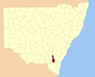
Coppabella, New South Wales is a rural locality of Hilltops Council and a civil parish of Harden County, New South Wales. [1] [2] [3]

Hilltops Council Local government area in New South Wales, Australia

Hilltops Council is a local government area in the South West Slopes region of New South Wales, Australia. This area was formed on the 12 May 2016 from the merger of Boorowa Council, Harden Shire and Young Shire. The local government area covers much the same area as the Hilltops wine region.

Lands administrative divisions of Australia

Lands administrative divisions of Australia are the cadastral divisions of Australia for the purposes of identification of land to ensure security of land ownership. Most states term these divisions as counties, parishes, hundreds, and other terms. The eastern states of Queensland, New South Wales, Victoria and Tasmania were divided into counties and parishes in the 19th century, although the Tasmanian counties were renamed land districts in the 20th century. Parts of South Australia (south-east) and Western Australia (south-west) were similarly divided into counties, and there were also five counties in a small part of the Northern Territory. However South Australia has subdivisions of hundreds instead of parishes, along with the Northern Territory, which was part of South Australia when the hundreds were proclaimed. There were also formerly hundreds in Tasmania. There have been at least 600 counties, 544 hundreds and at least 15,692 parishes in Australia, but there are none of these units for most of the sparsely inhabited central and western parts of the country.

The parish located at 34°44′54″S 148°30′04″E is on Coppabella and Juggion Creeks and the Hume Highway transverses to the southern boundary.

Civil parish Territorial designation and lowest tier of local government in England

In England, a civil parish is a type of administrative parish used for local government, they are a territorial designation which is the lowest tier of local government below districts and counties, or their combined form, the unitary authority. Civil parishes can trace their origin to the ancient system of ecclesiastical parishes which historically played a role in both civil and ecclesiastical administration; civil and religious parishes were formally split into two types in the 19th century and are now entirely separate. The unit was devised and rolled out across England in the 1860s.

Hume Highway highway in New South Wales and Victoria

The Hume Highway, inclusive of the sections now known as the Hume Freeway and Hume Motorway, is one of Australia's major inter-city national highways, running for 840 kilometres (520 mi) between Melbourne in the southwest and Sydney in the northeast. Upgrading of the route from Sydney's outskirts to Melbourne's outskirts to dual carriageway was completed on 7 August 2013.

Related Research Articles

Cowley County, New South Wales Cadastral in New South Wales, Australia

Cowley County is one of the 141 Cadastral divisions of New South Wales. It contains the locality of Cavan. It was originally bordered on the north, east and part of the south by the Murrumbidgee River, and on the west by the Goodradigbee River. A large part of the county was transferred to the Commonwealth to make the Australian Capital Territory in 1909, with the remaining part the area to the north-west of the ACT as far north as the Burrinjuck Dam, and thin strips of land along the western, southern and south-eastern borders of the ACT.

Nubba is a locality and former railway station on the Main South railway line in New South Wales, Australia, located midway between Wallendbeen and Harden. The station was open between 1882 and 1975 and has now been demolished. At the 2006 census, Nubba had a population of 281 people.

Napier is a locality in the Riverina district of New South Wales, Australia and also a civil parish of Buccleuch County, New South Wales.

Illalong is a rural locality just off the Burley Griffin Way in south New South Wales.

Peppercorn, New South Wales is a civil parish of Buccleuch County in Snowy Valleys Council, New South Wales.

Clive, New South Wales is a civil parish of Buccleuch County in New South Wales, Australia.

Baloo, New South wales is a rural locality in the Snowy Mountains of New South wales and a civil Parish of the Buccleuch County.]].

Blowering, New South Wales

Blowering, New South wales is a rural locality in the Snowy Mountains of New South wales and a civil Parish of Buccleuch County.

Bogong, New South Wales is a wilderness area in the Snowy Mountains of Australia.

Boraig, New South Wales is a rural locality in the Snowy Mountains, west of Canberra, Australia, and is also a civil Parish of Buccleuch County.

Birrema, New South Wales

Birrema, New South Wales is a civil parish of Harden County, New South Wales.

Childowla, New South Wales is a civil parish of Buccleuch County, New South Wales.

Currawong, New South Wales, is rural locality of Hilltops Council and is a civil parish of Harden County, New South Wales.

Bobbara, New South Wales

Bobbara, New South Wales is a rural locality just off the Burley Griffin Way in south New South Wales.

Cowcumbala, New South Wales

Cowcumbala, New South Wales is a rural locality and civil parish of Harden County, New South Wales.

Cumbamurra, New South Wales

Cumbamurra, New South Wales is a civil parish of Harden County, New South Wales.

Murrimboola, New South Wales New South Wales, Australia

Murrimboola, New South Wales is a rural locality and civil parish of Harden County, New South Wales. The parish is at Harden, New South Wales, on Currawong Creek.

Bramina is a rural locality of the Snowy Mountains and a civil parish of Buccleuch County, New South Wales.

Cromwell Parish is a rural locality of the Snowy Mountains and a civil parish of Buccleuch County, New South Wales.

The Parish of Yarara is a civil parish of Cowley County, New South Wales. The parish is between the Murrumbidgee River and the Australian Capital Territory border and is heavily forested. It lies to the west of Michelago, but is cut off from it by the Murrumbidgee and is only accessible by road from Tharwa or Williamsdale. It forms part of the current locality of Clear Range, which had a population of 36 at the 2016 census.

References

  1. Robert McLean, The New atlas of Australia : the complete work containing over one hundred maps and full descriptive geography of New South Wales, Victoria, Queensland, South Australia and Western Australia, together with numerous illustrations and copious indices (Sydney :J. Sands, [1886) Map 11.
  2. "Harden County". Geographical Names Register (GNR) of NSW. Geographical Names Board of New South Wales. OOjs UI icon edit-ltr-progressive.svg
  3. County of Cowley and Co. Buccleuch New South Wales, 1871 map, County of Cowley and Co. Buccleuch New South Wales, 1871 map.