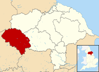
Craven is a local government district of North Yorkshire, England centred on the market town of Skipton. In 1974, Craven District was formed as the merger of Skipton urban district, Settle Rural District and most of Skipton Rural District, all in the West Riding of Yorkshire. The population of the Local Authority area at the 2011 Census was 55,409. It comprises the upper reaches of Airedale, Wharfedale, Ribblesdale, and includes most of the Aire Gap and Craven Basin.

Cross Hills is a village in the Craven district of North Yorkshire, England that is situated halfway between Skipton and Keighley. The village is at the centre of a built-up area that includes the adjoining settlements of Glusburn, Kildwick, Eastburn and Sutton-in-Craven. Cross Hills is the newer part of the civil parish now called Glusburn and Cross Hills, historically known as Glusburn.
Bowland at its most general most often refers to:
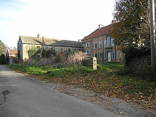
Kildwick, or Kildwick-in-Craven, is a village and civil parish of the district of Craven in North Yorkshire, England. It is situated between Skipton and Keighley and had a population of 191 in 2001, rising slightly to 194 at the 2011 census. Kildwick is a landmark as where the major road from Keighley to Skipton crosses the River Aire. The village's amenities include a primary school, church and public house.

Keighley is a constituency in West Yorkshire created in 1885 represented in the House of Commons of the UK Parliament since 2019 by Robbie Moore of the Conservative Party.

Airton is a small village and civil parish in the Craven district of North Yorkshire, England, situated 10 miles (16 km) north-west of Skipton. The village had a population of 175 according to the 2001 Census, increasing to 228 at the 2011 Census.

Appletreewick is a village and civil parish in the Craven district of North Yorkshire, England, 12 miles (19 km) north-east of Skipton, 7 miles (11 km) from Skipton railway station and 16 miles (25.7 km) from Leeds Bradford International Airport.

Buckden is a village and civil parish in the Craven district of North Yorkshire, England. Historically part of the West Riding of Yorkshire, Buckden is situated in the Yorkshire Dales National Park, and on the east bank of the River Wharfe in Wharfedale. The civil parish includes the hamlet of Cray and the whole of Langstrothdale. According to the 2011 Census the parish had a population of 187.
Burrill with Cowling is a civil parish in the Hambleton District of North Yorkshire, England, including the villages of Burrill and Cowling. It is only a 5-minute walk between the 2 small villages, which are 1 mile west of Bedale. It is a small parish surrounded by sparsely populated countryside and contains mainly detached and semi-detached houses. The closest city is Ripon 17 miles (27 km) and it is 234 miles from London. Burrill with Cowling is accessible by road from the A1(M) 3.1 miles to the east and the nearest railway station is 15 miles away in Northallerton.
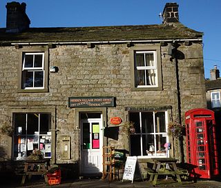
Hebden is a village and civil parish in the Craven District of North Yorkshire, England, and one of four villages in the ecclesiastical parish of Linton. It lies near Grimwith Reservoir and Grassington, in Wharfedale in the Yorkshire Dales National Park. In 2011 it had a population of 246.
Glusburn is a village and electoral ward in Craven in North Yorkshire, England. Historically part of the West Riding of Yorkshire, the village is situated on the edge of the Yorkshire Dales, sits on the A6068 Kildwick to Hapton road, and is conjoined to the village of Sutton-in-Craven at the south.

Cowling is a village, electoral division and civil parish in the Craven district of North Yorkshire, England. It is situated on the borders with the adjacent counties of West Yorkshire, and Lancashire.
The 1999 Craven District Council election took place on 6 May 1999 to elect members of Craven District Council in North Yorkshire, England. One third of the council was up for election and the Conservative party gained overall control of the council from no overall control.

The 2007 Craven District Council election took place on 3 May 2007 to elect members of Craven District Council in North Yorkshire, England. One third of the council was up for election and the council stayed under no overall control.

Wainman's Pinnacle, originally built as a folly, is a stone obelisk in Sutton-in-Craven, North Yorkshire, though it tends to be referred to as ‘Cowling Pinnacle’ and could also be seen as being a part of the village of Cowling. It has been a grade II listed building in the National Heritage List for England since 23 October 1984. Wainman’s Pinnacle is situated upon Earl Crag and is often associated with Lund’s Tower as they are both locally known as the Salt and Pepper Pots.

Earl Crag is a gritstone crag and climbing area in Craven, North Yorkshire, England. It is home to Lund's Tower, Wainman's Pinnacle, and The Hitching Stone, all of which are near Cowling.
This page is based on this
Wikipedia article Text is available under the
CC BY-SA 4.0 license; additional terms may apply.
Images, videos and audio are available under their respective licenses.