See also
| This page lists people with the surname Crisfield. If an internal link intending to refer to a specific person led you to this page, you may wish to change that link by adding the person's given name(s) to the link. |
Crisfield is a surname. Notable people with the surname include:
| This page lists people with the surname Crisfield. If an internal link intending to refer to a specific person led you to this page, you may wish to change that link by adding the person's given name(s) to the link. |

Crisfield is a town in Somerset County, Maryland, United States, located on the Tangier Sound, an arm of the Chesapeake Bay. The population was 2,726 at the 2010 census. It is included in the Salisbury, Maryland-Delaware Metropolitan Statistical Area. Crisfield has the distinction of being the southernmost incorporated city in Maryland.

John Woodland Crisfield was a U.S. Congressman from Maryland, representing the sixth district from 1847 to 1849 and the first district from 1861 to 1863. The city of Crisfield, Maryland, is named after him. Politically he was a strong supporter of the Union during American Civil War, opposing moves towards Maryland's secession. However he supported the institution of slavery and worked to prevent its abolition in Maryland.
Tawes is a surname. It is also applied to some buildings.

Maryland Route 358 is a state highway in the U.S. state of Maryland. Known as Jacksonville Road, the state highway runs 1.13 miles (1.82 km) from MD 413 in Crisfield north to the end of state maintenance near Alfred J. Lawson Road. MD 358 connects Crisfield with Janes Island State Park and Crisfield Municipal Airport. MD 358 was constructed on the south side of Crisfield in the mid-1920s. What is now MD 358 north of MD 413 was originally MD 475, which was built in the early 1930s. MD 358 was extended north through Crisfield in the 1940s, taking over MD 475. The portion of MD 358 south of MD 413 was later returned to the city of Crisfield and Somerset County.
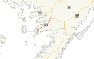
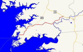
Maryland Route 413 is a 14.61-mile (23.51 km) state highway in Somerset County in the U.S. state of Maryland. The route runs from a dead end at Crisfield's city dock, which is located on the Tangier Sound, northeast to U.S. Route 13 in Westover. It is the main highway leading into Crisfield, and is known as Crisfield Highway for much of its length. The highway travels through mostly rural areas of farms and woods as well as the communities of Hopewell, Marion Station, and Kingston. It is a two-lane undivided road for most of its length; a portion of the road in Crisfield is a four-lane road that follows a one-way pair. MD 413 is part of two scenic routes: Chesapeake Country Scenic Byway and the Beach to Bay Indian Trail, both are Maryland Scenic Byways.

Maryland Route 380 is a state highway in the U.S. state of Maryland. The state highway runs 1.56 miles (2.51 km) from Ape Hole Road at Lawsonia north to Main Street at the city limit of Crisfield in southwestern Somerset County. MD 380, which is the southernmost state highway in Maryland, provides access to a suburban area south of Crisfield. The state highway was built in the mid-1930s.
Maryland Route 667 is a state highway in the U.S. state of Maryland. The highway runs 17.61 miles (28.34 km) from Chesapeake Avenue in Crisfield east to U.S. Route 13 in West Pocomoke. MD 667 forms the old alignment of MD 413 from Crisfield to Hudson Corner in southern Somerset County. The highway has a curvaceously course through the villages of Hopewell and Marion Station while MD 413 passes them on a straight course. The portion of MD 667 between Hudson Corner and West Pocomoke serves the community of Rehobeth. This segment, which was built as Maryland Route 406, serves as a shortcut allowing traffic between Crisfield and Pocomoke City to avoid Westover at the junction of MD 413 and US 13. Portions of MD 667 are part of the Beach to Bay Indian Trail.
WBEY-FM is a radio station broadcasting a Country music format. Licensed to Crisfield, Maryland, United States, the station is currently owned by GSB Media, LLC, and features programming from ABC Radio, WestwoodOne, Maryland News Network, and United Stations Radio Network.

Crisfield Academy and High School, also once known as simply Crisfield High School (CHS), is a public high school in the city of Crisfield in Somerset County, Maryland, United States. It is located in the Somerset County Public Schools district and handles five grades: 8th and 9th grade are handled in an "academy" section of the school, while grades 10 through 12 are handled as high school. The school is on North Somerset Avenue, between the intersections of Potomac Street and Mercury Lane, and is close to Maryland Route 413. It has the distinction of being the southernmost high school in the state of Maryland.

Crisfield Municipal Airport is a public airport located 3 miles (4.8 km) from Crisfield in Somerset County, Maryland, United States. Crisfield is located near the center of the Delmarva Peninsula in the heart of Bay Country. The Atlantic Ocean is 28 miles (45 km) to the east and the Chesapeake Bay just a few miles to the west. The Crisfield-Somerset County Airport is a joint venture of Somerset County and the City of Crisfield.
The J. Tawes Historical Museum is located on the Somers Cove Marina, Crisfield, Maryland, United States. The museum focuses on the history of the Lower Shore region, including the local people, towns and industry.
Somerset County Public Schools is a U.S. public school system serving the residents of Somerset County, Maryland.
Cedar Island Wildlife Management Area is a Wildlife Management Area in Somerset County, Maryland near Crisfield. The area is almost 3,000 acres (1,200 ha) in extent on Tangier Sound in Chesapeake Bay. The area was primarily established to protect black duck habitat and is notable for its concentration of the species.
Somers Cove Marina is a marina owned by the state of Maryland and governed by a seven-member Commission. It is located in Crisfield, Somerset County. 37°58.6 N, 75°51.9 W
Kingston is an unincorporated community in Somerset County, Maryland, United States. A small community at the head of navigation of the Big Annemessex River, it is located on Maryland Route 413 at the intersection of Kingston Lane. A very rural community far from any urban development, it is quite small in population, the land dominated by agricultural fields and tree farms.
Marion Station, also known as Marion, is an unincorporated community in Somerset County, Maryland, United States. It is located at the northern intersection of Maryland Route 413 and Maryland Route 667. After the arrival of the Pennsylvania Railroad arm known as the "Eastern Shore Railroad" toward Crisfield in 1866, Marion was locally hailed as the "strawberry capital of the world". After the trains stopped coming it has gone into decline, with some sources even hailing it as a ghost town.
Crisfield Historic District is a national historic district at Crisfield, Somerset County, Maryland, United States. It consists of a cohesive collection of houses, churches, and commercial buildings dating primarily from about 1870 to 1930. They reflect the rapid growth of the town as the center of the booming Chesapeake Bay oyster industry during that period. The district encompasses much of Crisfield's main residential and commercial areas, locally known as "uptown." The Crisfield Armory is located within the district boundaries.
Michael Anthony Crisfield was a British mathematician and structural analyst who became a leading figure in non-linear computational mechanics. He has died of cancer aged 59.
Crosfield is a surname. Notable people with the surname include:
WBYC-LP is a Variety formatted broadcast radio station licensed to Crisfield, Maryland, serving Crisfield and Hopewell in Maryland. WBYC-LP is owned and operated by The Somerset County Arts Council.