
A cave or cavern is a natural void in the ground, specifically a space large enough for a human to enter. Caves often form by the weathering of rock and often extend deep underground. The word cave can also refer to much smaller openings such as sea caves, rock shelters, and grottos, though strictly speaking a cave is exogene, meaning it is deeper than its opening is wide, and a rock shelter is endogene.
Lanzarote is a Spanish island, the northernmost and easternmost of the autonomous Canary Islands in the Atlantic Ocean. It is located approximately 125 kilometres off the north coast of Africa and 1,000 kilometres from the Iberian Peninsula. Covering 845.94 square kilometres, Lanzarote is the fourth-largest of the islands in the archipelago. With 149183 inhabitants, it is the third most populous Canary Island, after Tenerife and Gran Canaria. Located in the centre-west of the island is Timanfaya National Park, one of its main attractions. The island was declared a biosphere reserve by UNESCO in 1993. The island's capital is Arrecife.

Mount Teide is a volcano on Tenerife in the Canary Islands, Spain. Its summit is the highest point in Spain and the highest point above sea level in the islands of the Atlantic.

Kazumura Cave is a lava tube and has been surveyed at 40.7 miles long and 3,614 feet deep making it the longest and deepest lava tube in the world. The cave is located on the island of Hawaiʻi on the eastern slope of Kīlauea. Kīlauea is the most recently active volcano on the Big Island. The ʻAilāʻau lava flow that contains Kazumura Cave originated from the Kīlauea Iki Crater about 500 years ago.

Santa Brígida is a town and a municipality in the northeastern part of the island of Gran Canaria in the Province of Las Palmas of the Canary Islands. Its population is 18,791 (2013), and the area is 23.81 km². It is situated in the mountains, 13 km southwest of Las Palmas.

Malpaís de Güímar or Badlands of Guimar consist of a volcanic cone, subsidiary cones, and several basaltic lava flows in the Güímar municipality on the island of Tenerife, in the Canary Islands, Spain. They total in area about 290 hectares. The lava flows are quite recent, with the typical ʻaʻā type less than 10,000 years old. The large cone is called Montaña Grande and reaches a height of 276 m (906 ft).
Malpaís is a term used in the Southwestern United States, Spain, Mexico, and other Spanish-speaking regions for a rough and barren landscape that consists of relict and largely uneroded lava fields exhibiting recognizable lava flows, volcanic cones, and other volcanic landforms. This type of volcanic landscape is extremely rough and difficult to traverse. It is characteristic of an arid environment because in more humid climates, lava fields are quickly destroyed by weathering and erosion.
Túnel de la Atlántida is the world's longest known volcanic submarine lava tube located in the Canary Islands off the coast of North Africa. It is the underwater portion of the Cueva de los Verdes lava tube at Haría, Las Palmas. The 5,000-foot long tube formed some 20,000 years ago when the Monte Corona volcano erupted on the island of Lanzarote. The erupted molten rock flowed across the land and into the ocean.
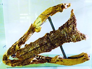
Gallotia goliath is an extinct giant lizard species from the island of Tenerife of the Canary Islands, Spain. This reptile lived before the arrival of humans and is believed to have grown to at least 0.9 metres (3.0 ft) long. It was described by the German herpetologist Robert Mertens. Fossils of this lizard have been found in volcanic caves, where they often appear with those of other animals, like the Tenerife giant rat.
Cueva del Viento is the largest lava tube system in Europe, and the fifth largest in the world, behind a series of lava tubes in Hawaii. It is also considered the most complex volcanic tube in the world, due to its morphology of several levels and passages.

The Gruta das Torres, is a lava cave, a geological formation of volcanic origin formed from the flow and cooling of subterranean magma rivers. This formation is located outside the parish of Criação Velha, in the municipality of Madalena, on the western flanks of the island of Pico. The cave system formed from a series of pāhoehoe lava flows which originating from the Cabeço Bravo parasitic cone about 500 to 1500 years ago. The caves are a group of interconnected lava tubes between 0.5–22 metres (2–72 ft) width, created from both pāhoehoe and ʻaʻā types of lavas generated during different geological periods. It has a height between 1.1 and 15 metres (3.6–49 ft) and is located at an elevation of 300 metres (980 ft). With an estimated length of over 5.2 km (3.2 mi) it is the longest lava cave in the Azores. Access to the cave was managed by the Mountaineering Association. Starting in 2011, AZORINA, SA took over the management and organization of the cave.
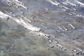
The 2011-2012 El Hierro eruption occurred just off the island of El Hierro, the smallest and farthest south and west of the Canary Islands, in the Atlantic Ocean off the coast of Africa. The island is also the youngest in the volcanic chain. The October 2011 - March 2012 eruption was underwater, with a fissure of vents located approximately 2 km to the south of the fishing village of La Restinga on the southern coast of the island. As of June 2012, increased seismicity to the north-west of the vent suggests another phase in the area's volcanic activity - comprising just deep-seated magma movements with associated earthquakes and deformation of the island at this June 2012 stage - is under way. A second phase of eruptive activity has not yet occurred, and it does not necessarily follow that it will occur.

Tanganasoga is the main volcano of El Hierro's El Golfo area in the Canary Islands, consisting of a cinder cone. The volcano is part of a much larger shield volcano system.

Pico de Malpaso is the highest point on the island of El Hierro in the Canary Islands, Spain.

The Guayadeque ravine, in Spanish Barranco de Guayadeque, is a ravine-type valley located on the Spanish municipalities of Ingenio and Agüimes, in the province of Las Palmas on Grand Canary island, off the coast of Morocco.

The Four Doors site, also known as mount Bermeja, is a complex of caves in the south of the municipality of Telde, Grand Canary.
The El Maipés necropolis is an ancient burial site near Agaete on the Spanish island of Grand Canary, province of Las Palmas in the Canary Islands of the west coast of Africa.
A lava balloon is a gas-filled bubble of lava that floats on the sea surface. It can be up to several metres in size. When it emerges from the sea, it is usually hot and often steaming. After floating for some time it fills with water and sinks again.


