
The Culgoa National Park is a protected national park that is located in the north-west region of New South Wales, in eastern Australia. The 35,239-hectare (87,080-acre) national park is located approximately 660 kilometres (410 mi) northwest of Sydney. The nearest town is Brewarrina, 120 kilometres (75 mi) away. The park's northern boundary is defined by part of the state border between New South Wales and Queensland.
The Culgoa Floodplain National Park is a protected national park that is located in the South West region of Queensland in eastern Australia. The 42,859-hectare (105,910-acre) national park is situated at the western extent of Hebel in the Shire of Balonne and in the east of Jobs Gate in the Paroo Shire, approximately 630 kilometres (390 mi) west of Brisbane. The park occupies the former pastoral and grazing property of Byra Station. The park's southern boundary is defined by part of the state border between Queensland and New South Wales.

The Darling River is the third-longest river in Australia, measuring 1,472 kilometres (915 mi) from its source in northern New South Wales to its confluence with the Murray River at Wentworth. Including its longest contiguous tributaries it is 2,844 km (1,767 mi) long, making it the longest river system in Australia. The Darling River is the outback's most famous waterway.
The Culgoa River is a river that is part of the Darling catchment within the Murray–Darling basin and is located in South West Queensland.

The Balonne River, part of the Murray-Darling Basin system, is a short yet significant part of the inland river group of South West Queensland, Australia.

Barwon River, a perennial river that is part of the Murray–Darling basin, is located in the north-west slopes and Orana regions of New South Wales, Australia.

Hebel is a rural town and locality in the Shire of Balonne, Queensland, Australia. It is on the border of Queensland and New South Wales. In the 2021 census, the locality of Hebel had a population of 62 people.

Dirranbandi is a rural town and locality in the Shire of Balonne, Queensland, Australia. The locality is on the border of Queensland with New South Wales. In the 2021 census, the locality of Dirranbandi had a population of 610 people.
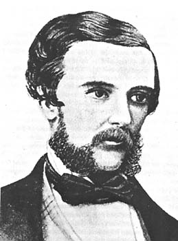
Edmund Besley Court Kennedy J. P. was an explorer in Australia in the mid nineteenth century. He was the Assistant-Surveyor of New South Wales, working with Sir Thomas Mitchell. Kennedy explored the interior of Queensland and northern New South Wales, including the Thomson River, the Barcoo River, Cooper Creek, and Cape York Peninsula. He died in December 1848 after being speared by Aboriginal Australians in far north Queensland near Cape York.

The Warrego River is an intermittent river that is part of the Darling catchment within the Murray–Darling basin, which is located in South West Queensland and in the Orana region of New South Wales, Australia. The Warrego River is the northernmost tributary of the Darling River.

The Shire of Balonne is a local government area in South West Queensland, Australia, over 500 kilometres (310 mi) from the state capital, Brisbane. It covers an area of 31,104 square kilometres (12,009.3 sq mi), and has existed as a local government entity since 1879. It is headquartered in its main town, St George.
The Kooma are a contemporary aggregation of Indigenous Australian peoples descending from tribes living in the border region of Queensland and New South Wales. They are descendants of the Koamu.

Narran County is one of the 141 cadastral divisions of New South Wales. It is bounded by the Culgoa River on the west, the Narran River in the east, the Queensland border in the north, and the Barwon River in the south. It includes Goodooga and the area to the north of Brewarrina.
Birrie River, a perennial river that is part of the Upper Darling catchment within the Murray–Darling basin, is located in the north-west slopes region of New South Wales, Australia.

The Mulga Lands are an interim Australian bioregion of eastern Australia consisting of dry sandy plains with low mulga woodlands and shrublands that are dominated by Acacia aneura (mulga). The Eastern Australia mulga shrublands ecoregion is coterminous with the Mulga Lands bioregion.

South West Queensland is a remote region in the Australian state of Queensland which covers 319,808 km2 (123,479 sq mi). The region lies to the south of Central West Queensland and west of the Darling Downs and includes the Maranoa district and parts of the Channel Country. The area is noted for its cattle grazing, cotton farming, opal mining and oil and gas deposits.
The Muruwari, also spelt Murawari, Murawarri, Murrawarri and other variants, are an Aboriginal Australian people of the state of New South Wales and the southwestern area of Queensland.
Jobs Gate is a rural locality in the Shire of Paroo, Queensland, Australia. It is on the border of Queensland and New South Wales. In the 2021 census, Jobs Gate had "no people or a very low population".