
Titchwell Marsh is an English nature reserve owned and managed by the Royal Society for the Protection of Birds (RSPB). Located on the north coast of the county of Norfolk, between the villages of Titchwell and Thornham, about 8 km (5.0 mi) east of the seaside resort of Hunstanton, its 171 hectares include reed beds, saltmarshes, a freshwater lagoon and sandy beach, with a small woodland area near the car park. This internationally important reserve is part of the North Norfolk Coast Site of Special Scientific Interest (SSSI) and the Norfolk Coast Area of Outstanding Natural Beauty (AONB), and is also protected through Natura 2000, Special Protection Area (SPA) and Ramsar listings.

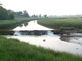
The River Tawe is a 30 miles (48 km) long river in South Wales. Its headwaters flow initially east from its source below Llyn y Fan Fawr south of Moel Feity in the Black Mountains, the westernmost range of the Brecon Beacons National Park, before the river turns south and then southwest to its estuary at Swansea. Its main tributaries are the right bank Upper and Lower Clydach Rivers and the Afon Twrch. The total area of the catchment is some 246 km2 (95 sq mi). The Tawe passes through a number of towns and villages including Ystradgynlais, Ystalyfera, Pontardawe, and Clydach and meets the sea at Swansea Bay below Swansea. The Tawe Valley is more commonly known as the Swansea Valley.

RSPB Dearne Valley Old Moor is an 89-hectare (220-acre) wetlands nature reserve in the Dearne Valley near Barnsley, South Yorkshire, run by the Royal Society for the Protection of Birds (RSPB). It lies on the junction of the A633 and A6195 roads and is bordered by the Trans Pennine Trail long-distance path. Following the end of coal mining locally, the Dearne Valley had become a derelict post-industrial area, and the removal of soil to cover an adjacent polluted site enabled the creation of the wetlands at Old Moor.

Clydach is both a village and a community in Swansea, Wales, within the Clydach ward and the Llangyfelach parish. It is located 6 miles (9.7 km) northeast of Swansea city centre. In 2011, the population was 7,503. Welsh is the first language of 24 per cent of the population and both Welsh and English language schools are available. The village lies close to the M4 motorway which can be accessed via the bypass or old road via Ynystawe. The community includes part of the village of Glais.

The Swansea Canal was a canal constructed by the Swansea Canal Navigation Company between 1794 and 1798, running for 16.5 miles (26.6 km) from Swansea to Hen Neuadd, Abercraf in South Wales. It was steeply graded, and 36 locks were needed to enable it to rise 373 feet (114 m) over its length. The main cargos were coal, iron and steel, and the enterprise was profitable.

The Lower Clydach River is a river in South Wales which rises on the slopes of Mynydd y Betws west of Cwmgors and flows for around 10 km through Cwm Clydach to its confluence with the River Tawe at Clydach. It runs through the RSPB's Cwm Clydach Nature Reserve just to the north of Clydach. - 51.69581°N 3.8992°W.
The River Clyst is a river of Devon, England. The name derives from Old English, and translates as Clean-stream. The river lends its name to several settlements on its route, Clyst Honiton, Clyst St Lawrence, Clyst St George, and Broadclyst. The William part of Clyst William derives from the Old English of aewelm, which means river source.
Craig-cefn-parc is a village near Clydach, outside Swansea, Wales. It falls within the Mawr ward of Swansea. The name means "park ridge rock". Cwm Clydach RSPB nature reserve is located at the south of the village, near the New Inn Public House, at the boundary between Craig-cefn-parc and Clydach. Craig-cefn-parc is famous for its mining history with several large drift mines employing hundreds of men. In the heart of the Lower Clydach River are some of the old coal houses, there is also a coal tram located in the centre of the village to commemorate its mining history. Craig Cefn Parc school was closed in 2019. A small memorial garden was created lower down in the village for a place to reflect and sit for a while. The village has a small store, a community building and playing fields. In 2020 funding was obtained for a children's park and play area.
The Clydach Gorge is a steep-sided valley in south-east Wales down which the River Clydach flows to the River Usk. It runs for 5.6 kilometres (3.5 mi) from the vicinity of Brynmawr in Blaenau Gwent eastwards and northeastwards to Gilwern in Monmouthshire. The Gorge was one of the first locations in the region to be industrialised though it still retains its natural environment. It has long been an important transport corridor between Abergavenny and the lowlands of Monmouthshire and the northeastern quarter of the South Wales Coalfield. It is now exploited by the A465 Heads of the Valleys trunk road which runs between Abergavenny and Swansea and which serves the Heads of the Valleys sub-region.
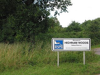
Highnam Wood is a nature reserve located in Gloucestershire and established by the RSPB to protect bird species in the region. A two-kilometre nature trail passes through the park, giving tourists a view of Britain's rarest breeding woodpecker species, the Lesser Spotted Woodpecker. Marsh Tit, Nightingale, Song Thrush, and Spotted Flycatchers also frequent the park.
Middleton Lakes RSPB reserve is a 160 hectares nature reserve, formally opened on 19 May 2011, created and run by the Royal Society for the Protection of Birds at Middleton, Warwickshire, England, just south of Tamworth. The Northern part of the reserve lies in Staffordshire, yet the reserve is only a few minutes from the outskirts of Birmingham.

The Afon Sawdde is a river in the county of Carmarthenshire, Wales. For most of its course it flows through the Brecon Beacons National Park and Fforest Fawr Geopark.

Rye Meads is a 58.5-hectare (145-acre) biological Site of Special Scientific Interest (SSSI) in Rye House, Hoddesdon, Hertfordshire. It is one of series of wetlands and reservoirs situated along the River Lea, to the north-east of London. It is part of the Lea Valley Ramsar site and a Special Protection Area.
Cwm Clydach National Nature Reserve is a 24.8 hectares area of steeply sloping valley-side on Clydach Gorge, 2 miles (3.2 km) east of Brynmawr, southeast Wales. It is protected for its ancient semi-natural beech woods, designated by the Nature Conservancy Council.
The Upper Clydach River runs from a poorly drained area south of Cwmgors and flows south and southeast through Cwm Gors for about 7 km to join the River Tawe at Pontardawe - 51.71775°N 3.84873°W. Each of the rivers bearing the name 'Clydach' in South Wales is thought to derive from an earlier Celtic word 'klou' or 'kleu' together with the suffix '-ach' which is of Irish origin. The sense is of a 'strong-flowing', 'washing' or stony river.
Cwm Clydach may refer to:
The Neath & District League is a football league in South Wales. The league consists of four divisions, named The Premier Division, Division One, Two and Three. The Premier League is a feeder to the West Wales Premier League, and therefore sits at level 5 of the Welsh football league system.

Geltsdale & Glendue Fells is a Site of Special Scientific Interest in the North Pennines, England. The site has an area of 8059 ha, partly in Cumbria and partly in Northumberland.
Cwm Clydach is a community and electoral ward to the northwest of Tonypandy in Rhondda Cynon Taf, Wales. The community and ward covers the valley of the Nant Clydach, which includes the cojoined villages of Clydach Vale and Blaenclydach.