
Crickhowell is a town and community in southeastern Powys, Wales, near Abergavenny, and is in the historic county of Brecknockshire.

Google Maps is a web mapping platform and consumer application offered by Google. It offers satellite imagery, aerial photography, street maps, 360° interactive panoramic views of streets, real-time traffic conditions, and route planning for traveling by foot, car, bike, air and public transportation. As of 2020, Google Maps was being used by over one billion people every month around the world.

Bwlch is a small village and an electoral ward in the community of Cwmdu and District, Powys, south Wales. The settlement is strung out along the A40 road which crosses a low col above the Usk Valley at this point on its route between Brecon and Crickhowell.

Llangynidr is a village, community and electoral ward in Powys, Wales, about 4 miles (6.4 km) west of Crickhowell and 9 miles (14.5 km) south-east of Brecon. The River Usk flows through the village as does the Monmouthshire and Brecon Canal. It is in the historic county of Brecknockshire.
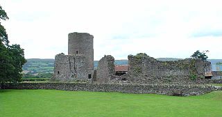
Tretower Castle is a Grade I-listed ruined castle in the village of Tretower in the county of Powys, Wales. It was built around the beginning of the twelfth century as a motte and bailey castle and this was probably replaced mid-century by a stone shell keep. The castle was enlarged in the early thirteenth century, but later fell into ruin.

Cockett is the name of an electoral ward in the City and County of Swansea, Wales, UK. The ward is coterminous with the Cockett community. It elects three councillors.

Cwmbwrla is the name of an electoral ward in the City and County of Swansea, Wales, including the suburb of the same name.
Cwmdu is a suburban district of the City and County of Swansea, Wales. The western part falls within the Cockett ward and the eastern part falls within the Cwmbwrla ward. Cwmdu approximates to the settlement around Middle Road between Cwmbwrla and Gendros. The neighboring districts are Gendros, Townhill and Cockett.
Gendros is a suburban district of the City and County of Swansea, Wales falling within the Cockett ward. Gendros approximates to the settlement northwest of Carmarthen Road between Cwmdu and Penlan. Other areas surrounding Gendros are Blaen-y-Maes, Ravenhill, Cwmbwrla, Cockett, Fforestfach and Mayhill and Townhill. Its post code begins with SA5.

Cwmdu or Llanfihangel Cwmdu is a small village in the community of Cwmdu and District, situated in the heart of the Black Mountains in Powys, Wales. Its name is derived from the Welsh language "Cwm Du", which means 'Black Valley'. It is located on the A479 Talgarth to Tretower road. Nearby towns include Crickhowell and Abergavenny. The population of the community, Llanfihangel Cwmdu with Bwlch and Cathedine, which includes Cwmdu and nearby villages Bwlch, and Tretower. Cathedine is actually in the neighbouring community of Llangors. as of the 2011 UK Census was 1026. It is in the historic county of Brecknockshire.
Ysgol Gyfun Gymraeg Llangynwyd is a Welsh-medium secondary school for pupils aged between 11 and 18. The school is based in the village of Llangynwyd in the borough of Bridgend, Wales. The school opened on 3 September 2008 on the site of the former Maesteg Comprehensive Upper School in Llangynwyd. It is the only secondary school in the borough of Bridgend to use the Welsh language as the primary medium of education.

The A479, officially also known as the Glanusk Park (Crickhowell)—Llyswen Trunk Road, is a trunk road in Wales. It connects Crickhowell to Llyswen via the Rhiangoll valley and Talgarth, running through the Brecon Beacons National Park.

Mynydd Llangorse is a hill on the western edge of the Black Mountains in the Brecon Beacons National Park in Powys, south Wales. It lies two miles east of Llangors and its lake and 5 miles south of Talgarth. Its summit at 515m overtops the location 600m to the south at which a trig point is sited by 9m. The broad spur of Cefn Moel extends south towards the village of Bwlch whilst a spur to the southeast forms Pen Tir which reaches just over 450m above sea level. It is a Marilyn with a prominence of 161 metres.
Tretower is a hamlet in the community of Cwmdu and District, in the southern part of the county of Powys in Wales. It lies on the A479 road within the Brecon Beacons National Park at the foot of the Black Mountains just off the Usk Valley. Tretower is frequented by tourists visiting the impressive Tretower Court and the nearby ruins of Tretower Castle, both of which are now managed by Cadw. Cadw own the Court whilst ownership of the Castle lies with the owner of Tyllys Farm in the centre of the village.

Garth is a village in Bridgend County Borough, Wales. Garth is situated to the east of the town of Maesteg, and lies at the northernmost end of the Llynfi Valley. During the 19th century Garth was an industrial coal-mining village which contained its own colliery, the Garth Merthyr Colliery.
Semi-submersible may refer to a self-propelled vessel, such as:
Jammu and Kashmir may refer to:

Cwmdu railway station served the hamlet of Cwmdu, in the historical county of Glamorganshire, Wales, from 1913 to 1932 on the Port Talbot Railway.
This page is based on this
Wikipedia article Text is available under the
CC BY-SA 4.0 license; additional terms may apply.
Images, videos and audio are available under their respective licenses.