
USS Block Island (CVE-21/AVG-21/ACV-21) was a Bogue-class escort carrier for the United States Navy during World War II. She was the first of two escort carriers named after Block Island Sound off Rhode Island and was the only American carrier sunk in the Atlantic during the war.

Villalmanzo is a village and municipality of the province of Burgos, in the autonomous community of Castile and León, Spain.
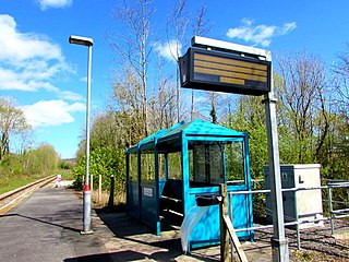
Cynghordy railway station serves the rural community of Cynghordy near Llandovery, Carmarthenshire, Wales. The station is on the Heart of Wales Line 46+3⁄4 miles (75 km) north east of Swansea and is located at street level at the end of a gravel track off a lane that is just off the main A483 road.

Çınar is a district of Diyarbakır Province of Turkey. Its population is 74,207 according to Turkish government statistics as of 2018.
The Ram Range is a mountain range of the Canadian Rockies located in David Thompson Country, Canada. The range extends southeast from Abraham Lake to the Ram River. It is bounded on the southwest by Whiterabbit Creek.

Breidden Hill is an extinct volcanic hill in Powys, Wales, near the town of Welshpool. It is immediately surrounded by the villages of Trewern, Middletown, Criggion, Crew Green and Llandrinio. The peak of the hill reaches to 367 metres (1,204 ft). Footpaths which lead up to the summit provide excellent 360 degree views over Powys and over the border with England to the Shropshire Plain.

Tordómar is a municipality and town located in the province of Burgos, Castile and León, Spain. According to the 2004 census (INE), the municipality has a population of 351 inhabitants.

The Afon Twymyn is a river in Powys, Mid Wales.
Skrzypki Duże is a village in the administrative district of Gmina Bielsk Podlaski, within Bielsk County, Podlaskie Voivodeship, in north-eastern Poland. It lies approximately 11 kilometres (7 mi) west of Bielsk Podlaski and 44 km (27 mi) south of the regional capital Białystok.

Charnwood Lodge is a 134.2-hectare (332-acre) biological and geological Site of Special Scientific Interest in Charnwood Forest, east of Coalville in Leicestershire. It is a national nature reserve, and contains two Geological Conservation Review sites. It is managed by the Leicestershire and Rutland Wildlife Trust.

The Afon Brân is a tributary of the River Towy in mid Wales. Its headwaters rise in Irfon Forest in the northeastern corner of Carmarthenshire as the Cynnant Fawr and Afon Lwynor and the river assumes the name of Afon Brân at their confluence to the north of the village of Cynghordy. Its major tributary is the Afon Gwydderig which joins it at Llandovery. Other tributaries include the Nant Bargod, Cynnant Fach, Afon Gwyddon, Nant Hirgwm, Nant Cwm-neuadd, Bawddwr and Afon Crychan with its own minor tributary the Afon Dulais.
Soolu is a village in Lääne-Nigula Parish, Lääne County, in western Estonia.

Christoffersen Island is a small island immediately west of the southern end of Powell Island in the South Orkney Islands of Antarctica. The name appears on a chart by Norwegian whaling captain Petter Sorlle, who made a running survey of these islands in 1912–13.
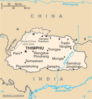
This is a list of the extreme points of Bhutan.
Sardarabad Rural District is a rural district (dehestan) in the Central District of Shushtar County, Khuzestan Province, Iran. At the 2006 census, its population was 23,930, in 4,464 families. The rural district has 13 villages.
Gaer Fawr is an Iron Age hill fort located near Llanilar, Ceredigion, Wales; the Ordnance Survey grid reference is SN648718.
This page is based on this
Wikipedia article Text is available under the
CC BY-SA 4.0 license; additional terms may apply.
Images, videos and audio are available under their respective licenses.
