
Grand Canyon National Park, located in northwestern Arizona, is the 15th site in the United States to have been named as a national park. The park's central feature is the Grand Canyon, a gorge of the Colorado River, which is often considered one of the Wonders of the World. The park, which covers 1,217,262 acres of unincorporated area in Coconino and Mohave counties, received more than six million recreational visitors in 2017, which is the second highest count of all American national parks after Great Smoky Mountains National Park. The Grand Canyon was designated a World Heritage Site by UNESCO in 1979. The park celebrated its 100th anniversary on February 26, 2019.

The Grand Canyon is a steep-sided canyon carved by the Colorado River in Arizona, United States. The Grand Canyon is 277 miles (446 km) long, up to 18 miles (29 km) wide and attains a depth of over a mile.

A canyon, or gorge, is a deep cleft between escarpments or cliffs resulting from weathering and the erosive activity of a river over geologic time scales. Rivers have a natural tendency to cut through underlying surfaces, eventually wearing away rock layers as sediments are removed downstream. A river bed will gradually reach a baseline elevation, which is the same elevation as the body of water into which the river drains. The processes of weathering and erosion will form canyons when the river's headwaters and estuary are at significantly different elevations, particularly through regions where softer rock layers are intermingled with harder layers more resistant to weathering.

Grand Canyon Village is a census-designated place (CDP) located on the South Rim of the Grand Canyon, in Coconino County, Arizona, United States. Its population was 2,004 at the 2010 Census. Located in Grand Canyon National Park, it is wholly focused on accommodating tourists visiting the canyon. Its origins trace back to the railroad completed from Williams, to the canyon's South Rim by the Santa Fe Railroad in 1901. Many of the structures in use today date from that period. The village contains numerous landmark buildings, and its historic core is a National Historic Landmark District, designated for its outstanding implementation of town design.
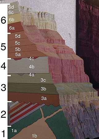
The geology of the Grand Canyon area includes one of the most complete and studied sequences of rock on Earth. The nearly 40 major sedimentary rock layers exposed in the Grand Canyon and in the Grand Canyon National Park area range in age from about 200 million to nearly 2 billion years old. Most were deposited in warm, shallow seas and near ancient, long-gone sea shores in western North America. Both marine and terrestrial sediments are represented, including lithified sand dunes from an extinct desert. There are at least 14 known unconformities in the geologic record found in the Grand Canyon.

The Colorado Plateau, also known as the Colorado Plateau Province, is a physiographic and desert region of the Intermontane Plateaus, roughly centered on the Four Corners region of the southwestern United States. This province covers an area of 336,700 km2 (130,000 mi2) within western Colorado, northwestern New Mexico, southern and eastern Utah, northern Arizona, and a tiny fraction in the extreme southeast of Nevada. About 90% of the area is drained by the Colorado River and its main tributaries: the Green, San Juan, and Little Colorado. Most of the remainder of the plateau is drained by the Rio Grande and its tributaries.

The Havasupai people are an American Indian tribe who have lived in the Grand Canyon for at least the past 800 years. Havasu means "blue-green water" and pai "people".

The known human history of the Grand Canyon area stretches back 10,500 years, when the first evidence of human presence in the area is found. Native Americans have inhabited the Grand Canyon and the area now covered by Grand Canyon National Park for at least the last 4,000 of those years. Ancestral Pueblo peoples, first as the Basketmaker culture and later as the more familiar Pueblo people, developed from the Desert Culture as they became less nomadic and more dependent on agriculture. A similar culture, the Cochimi also lived in the canyon area. Drought in the late 13th century likely caused both groups to move on. Other people followed, including the Paiute, Cerbat, and the Navajo, only to be later forced onto reservations by the United States Government.
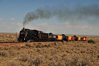
The Grand Canyon Railway is a heritage railroad which carries passengers between Williams, Arizona, and the South Rim of Grand Canyon National Park.
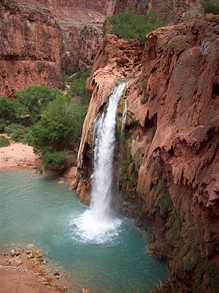
Havasu Falls is a waterfall of Havasu Creek, located in the Grand Canyon, Arizona, United States. It is within Havasupai tribal lands.

Grand Canyon University (GCU) is a private for-profit Christian university in Phoenix, Arizona. Based on student enrollment, Grand Canyon University was the largest Christian university in the world in 2018, with 20,000 attending students on campus and 70,000 online.
Grand Canyon Airlines is a 14 CFR Part 135 air carrier headquartered on the grounds of Boulder City Municipal Airport in Boulder City, Nevada, United States. It also has bases at Grand Canyon National Park Airport and Page Municipal Airport, both in Arizona. It operates sightseeing tours and charter service over and around the Grand Canyon. Its headquarters and main operation center is Grand Canyon National Park Airport and Boulder City Municipal Airport. The company slogan is With Grand Canyon Airlines, Your Memories are Cleared for Takeoff!

The Havasupai Indian Reservation is a Native American reservation for the Havasupai people, surrounded entirely by the Grand Canyon National Park, in Coconino County in Arizona, United States. It is considered one of America's most remote Indian reservations. The reservation is governed by a seven-member tribal council, led by a chairman who is elected from among the members of the council. The capital of the reservation is Supai, situated at the bottom of Cataract Canyon, one of the tributary canyons of the Grand Canyon. Havasupai is a combination of the words Havasu and pai, thus meaning "people of the blue-green waters".
The Colville people, are a Native American people of the Pacific Northwest. The name Colville comes from association with Fort Colville, named after Andrew Colvile of the Hudson's Bay Company. Okanagan: sx̌ʷyʔiɬpx) Earlier, outsiders often called them Scheulpi, Chualpay, or Swhy-ayl-puh; the French traders called them Les Chaudières in reference to Kettle Falls. The neighboring Coeur d'Alene called them Sqhwiyi̱'ɫpmsh and the Spokane knew them as Sxʷyelpetkʷ.
Tom Mooney is an Australian former professional rugby league footballer who played in the 1970s. He played in Sydney's New South Wales Rugby Football League premiership as a wing for the Manly-Warringah and South Sydney clubs. Mooney won the 1976 and 1978 premierships with Manly.

Grand Canyon Scenic Airlines is an American regional airline based in Paradise, Nevada, United States. It operates sightseeing flights from Boulder City Municipal Airport in Boulder City, Nevada. Scenic has been owned by Grand Canyon Airlines since 2008.
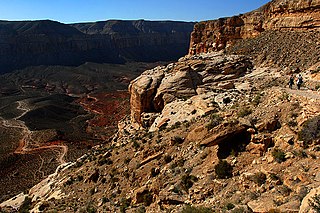
Havasupai Trail is the main trail to Supai, Arizona, and to Havasu Falls. There are other trails, such as the Topocoba, Moqui and Kirby trails. However, these other trails are not maintained. As far back as 1976, they were described as ranging from "in poor repair" to "primitive, dangerous foot trails." Special permission is required to use any such trail.

Havasu Creek is a stream in the U.S. state of Arizona associated with the Havasupai people. It is a tributary to the Colorado River, which it enters in the Grand Canyon.

The Surprise Canyon Formation is a geologic formation that consists of clastic and calcareous sedimentary rocks that fill paleovalleys and paleokarst of Late Mississippian (Serpukhovian) age in Grand Canyon. These strata outcrop as isolated, lens-shaped exposures of rocks that fill erosional valleys and locally karsted topography and caves developed in the top of the Redwall Limestone. The Surprise Canyon Formation and associated unconformities represent a significant period of geologic time between the deposition of the Redwall Limestone and the overlying Supai Group.

The Redwall Limestone is a resistant cliff-forming unit of Mississippian age that forms prominent, red-stained cliffs in the Grand Canyon, ranging in height from 500 feet (150 m) to 800 feet (240 m).
