Dagamtenga Peulh | |
|---|---|
 Dagamtenga Peulh Location within Burkina Faso, French West Africa | |
| Coordinates: 11°52′33.56″N0°22′15.46″W / 11.8759889°N 0.3709611°W | |
| Country | |
| Province | Kouritenga |
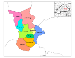
| Department | Dialgaye |
| Elevation | 312 m (1,024 ft) |
| Population (2006) | |
• Total | 180 |
| Time zone | UTC+0 (GMT) |
Dagamtenga Peulh, also called Dagemtenga 2, [1] is a commune in the Dialgaye Department of Kouritenga Province in the Centre-Est region of Burkina Faso. It had a population of 180 in 2006. [2] [3]