A statistician is a person who works with theoretical or applied statistics. The profession exists in both the private and public sectors.
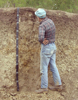
Soil science is the study of soil as a natural resource on the surface of the Earth including soil formation, classification and mapping; physical, chemical, biological, and fertility properties of soils; and these properties in relation to the use and management of soils.

Science education is the teaching and learning of science to school children, college students, or adults within the general public. The field of science education includes work in science content, science process, some social science, and some teaching pedagogy. The standards for science education provide expectations for the development of understanding for students through the entire course of their K-12 education and beyond. The traditional subjects included in the standards are physical, life, earth, space, and human sciences.
The University of California, Santa Barbara is a public land-grant research university in Santa Barbara County, California, United States. Tracing its roots back to 1891 as an independent teachers' college, UCSB joined the University of California system in 1944. It is the third-oldest undergraduate campus in the system, after UC Berkeley and UCLA.
A Bachelor of Applied Science is an undergraduate academic degree of applied sciences.

Yang Chen-Ning or Chen-Ning Yang, also known as C. N. Yang or by the English name Frank Yang, is a Chinese theoretical physicist who made significant contributions to statistical mechanics, integrable systems, gauge theory, and both particle physics and condensed matter physics. He and Tsung-Dao Lee received the 1957 Nobel Prize in Physics for their work on parity non-conservation of weak interaction. The two proposed that the conservation of parity, a physical law observed to hold in all other physical processes, is violated in the so-called weak nuclear reactions, those nuclear processes that result in the emission of beta or alpha particles. Yang is also well known for his collaboration with Robert Mills in developing non-abelian gauge theory, widely known as the Yang–Mills theory.

Alexei Alexeyevich Abrikosov was a Soviet, Russian and American theoretical physicist whose main contributions are in the field of condensed matter physics. He was the co-recipient of the 2003 Nobel Prize in Physics, with Vitaly Ginzburg and Anthony James Leggett, for theories about how matter can behave at extremely low temperatures.

Joseph Hooton Taylor Jr. is an American astrophysicist and Nobel Prize laureate in Physics for his discovery with Russell Alan Hulse of a "new type of pulsar, a discovery that has opened up new possibilities for the study of gravitation."

VictorFrederick "Viki" Weisskopf was an Austrian-born American theoretical physicist. He did postdoctoral work with Werner Heisenberg, Erwin Schrödinger, Wolfgang Pauli, and Niels Bohr. During World War II he was Deputy Division Leader of the Theoretical Division of the Manhattan Project at Los Alamos, and he later campaigned against the proliferation of nuclear weapons.

David Allan Bromley was a Canadian-American physicist, academic administrator and science advisor to President George H. W. Bush. His field of research was the study of low-energy nuclear reactions and structure using heavy ion beams.

The Center for Astrophysics | Harvard & Smithsonian (CfA), previously known as the Harvard–Smithsonian Center for Astrophysics, is an astrophysics research institute jointly operated by the Harvard College Observatory and Smithsonian Astrophysical Observatory. Founded in 1973 and headquartered in Cambridge, Massachusetts, United States, the CfA leads a broad program of research in astronomy, astrophysics, Earth and space sciences, as well as science education. The CfA either leads or participates in the development and operations of more than fifteen ground- and space-based astronomical research observatories across the electromagnetic spectrum, including the forthcoming Giant Magellan Telescope (GMT) and the Chandra X-ray Observatory, one of NASA's Great Observatories.
The Atlantic Oceanographic and Meteorological Laboratory (AOML), a federal research laboratory, is part of the National Oceanic and Atmospheric Administration's (NOAA) Office of Oceanic and Atmospheric Research (OAR), located in Miami in the United States. AOML's research spans tropical cyclone and hurricanes, coastal ecosystems, oceans and human health, climate studies, global carbon systems, and ocean observations. It is one of seven NOAA Research Laboratories (RLs).

Louis Agricola Bauer was an American geophysicist, astronomer and magnetician.

Robert P. Kirshner is an American astronomer, Chief Program Officer for Science for the Gordon and Betty Moore Foundation, and the Clownes Research Professor of Science at Harvard University. Kirshner has worked in several areas of astronomy including the physics of supernovae, supernova remnants, the large-scale structure of the cosmos, and the use of supernovae to measure the expansion of the universe.

Busch Campus is one of the five sub-campuses at Rutgers University's New Brunswick/Piscataway area campus, and is located entirely within Piscataway, New Jersey, US. Academic facilities and departments centered on this campus are primarily those related to the natural sciences: physics, pharmacy, engineering, psychology, mathematics and statistics, chemistry, geology, and biology. The Rutgers Medical School was also built on this campus in 1966, but four years later in 1970 was separated by the state and merged with the New Jersey Medical School and other health profession schools in Newark and New Brunswick to create the College of Medicine and Dentistry of New Jersey. Rutgers and the medical school, renamed Robert Wood Johnson Medical School in 1986, continued to share the land and facilities on the campus in a slightly irregular arrangement. On July 1, 2013, Robert Wood Johnson Medical School was officially merged back into Rutgers University, along with most of the other schools of UMDNJ, with the exception of the UMDNJ-School of Osteopathic Medicine.

The Physics of Star Trek is a 1995 non-fiction book by the theoretical physicist Lawrence M. Krauss. It is the third book by Krauss, who later wrote a follow-up titled Beyond Star Trek in 1997.

The Astronomy and Astrophysics Decadal Survey is a review of astronomy and astrophysics literature produced approximately every ten years by the National Research Council of the National Academy of Sciences in the United States. The report surveys the current state of the field, identifies research priorities, and makes recommendations for the coming decade. The decadal survey represents the recommendations of the research community to governmental agencies on how to prioritize scientific funding within astronomy and astrophysics. The editing committee is informed by topical panels and subcommittees, dedicated conferences, and direct community input in the form of white papers summarizing the state of the art in each subdiscipline. The most recent report, Astro2020, was released in 2021.

The Planetary Science Decadal Survey is a serial publication of the United States National Research Council produced for NASA and other United States Government Agencies such as the National Science Foundation. The documents identify key questions facing planetary science and outlines recommendations for space and ground-based exploration ten years into the future. Missions to gather data to answer these big questions are described and prioritized, where appropriate. Similar decadal surveys cover astronomy and astrophysics, earth science, and heliophysics.
Craig E. Manning is a professor of geology and geochemistry in the Department of Earth, Planetary, and Space Sciences at the University of California, Los Angeles, where he served as department chair between 2009 and 2012. Manning's research interests include water chemistry, thermodynamics, gas chemistry, geochemistry, igneous petrology, and metamorphic petrology.
Judith L. Lean is an Australian-American solar and climate scientist. She is a senior scientist at the United States Naval Research Laboratory. Lean is a three time recipient of the NASA Group Achievement Award and an elected member and fellow of several academic societies.