
In astronomy, declination is one of the two angles that locate a point on the celestial sphere in the equatorial coordinate system, the other being hour angle. Declination's angle is measured north or south of the celestial equator, along the hour circle passing through the point in question.
Right ascension is the angular distance of a particular point measured eastward along the celestial equator from the Sun at the March equinox to the point in question above the earth. When paired with declination, these astronomical coordinates specify the location of a point on the celestial sphere in the equatorial coordinate system.

A compass is a device that shows the cardinal directions used for navigation and geographic orientation. It commonly consists of a magnetized needle or other element, such as a compass card or compass rose, which can pivot to align itself with magnetic north. Other methods may be used, including gyroscopes, magnetometers, and GPS receivers.

An azimuth is an angular measurement in a spherical coordinate system. More specifically, it is the horizontal angle from a cardinal direction, most commonly north.
The equatorial coordinate system is a celestial coordinate system widely used to specify the positions of celestial objects. It may be implemented in spherical or rectangular coordinates, both defined by an origin at the centre of Earth, a fundamental plane consisting of the projection of Earth's equator onto the celestial sphere, a primary direction towards the vernal equinox, and a right-handed convention.
The horizontal coordinate system is a celestial coordinate system that uses the observer's local horizon as the fundamental plane to define two angles: altitude and azimuth. Therefore, the horizontal coordinate system is sometimes called as the az/el system, the alt/az system, or the alt-azimuth system, among others. In an altazimuth mount of a telescope, the instrument's two axes follow altitude and azimuth.

North is one of the four compass points or cardinal directions. It is the opposite of south and is perpendicular to east and west. North is a noun, adjective, or adverb indicating direction or geography.

In navigation, bearing or azimuth is the horizontal angle between the direction of an object and north or another object. The angle value can be specified in various angular units, such as degrees, mils, or grad. More specifically:
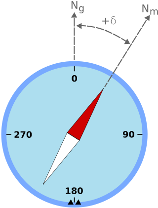
Magnetic declination, or magnetic variation, is the angle on the horizontal plane between magnetic north and true north. This angle varies depending on position on the Earth's surface and changes over time.
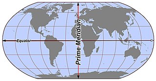
In geography and geodesy, a meridian is the locus connecting points of equal longitude, which is the angle east or west of a given prime meridian. In other words, it is a line of longitude. The position of a point along the meridian is given by that longitude and its latitude, measured in angular degrees north or south of the Equator. On a Mercator projection or on a Gall-Peters projection, each meridian is perpendicular to all circles of latitude. A meridian is half of a great circle on Earth's surface. The length of a meridian on a modern ellipsoid model of Earth has been estimated as 20,003.93 km (12,429.87 mi).
The solar azimuth angle is the azimuth of the Sun's position. This horizontal coordinate defines the Sun's relative direction along the local horizon, whereas the solar zenith angle defines the Sun's apparent altitude.
In a spherical coordinate system, a colatitude is the complementary angle of a given latitude, i.e. the difference between a right angle and the latitude. Here Southern latitudes are defined to be negative, and as a result the colatitude is a non-negative quantity, ranging from zero at the North pole to 180° at the South pole.
An astrocompass is a navigational tool for determining the direction of true north through the positions of various astronomical bodies.

Magnetic dip, dip angle, or magnetic inclination is the angle made with the horizontal by the Earth's magnetic field lines. This angle varies at different points on the Earth's surface. Positive values of inclination indicate that the magnetic field of the Earth is pointing downward, into the Earth, at the point of measurement, and negative values indicate that it is pointing upward. The dip angle is in principle the angle made by the needle of a vertically held compass, though in practice ordinary compass needles may be weighted against dip or may be unable to move freely in the correct plane. The value can be measured more reliably with a special instrument typically known as a dip circle.
Position resection and intersection are methods for determining an unknown geographic position by measuring angles with respect to known positions. In resection, the one point with unknown coordinates is occupied and sightings are taken to the known points; in intersection, the two points with known coordinates are occupied and sightings are taken to the unknown point.

The north magnetic pole, also known as the magnetic north pole, is a point on the surface of Earth's Northern Hemisphere at which the planet's magnetic field points vertically downward. There is only one location where this occurs, near the geographic north pole. The geomagnetic north pole is the northern antipodal pole of an ideal dipole model of the Earth's magnetic field, which is the most closely fitting model of Earth's actual magnetic field.
An azimuth compass is a nautical instrument used to measure the magnetic azimuth, the angle of the arc on the horizon between the direction of the sun or some other celestial object and the magnetic north. This can be compared to the true azimuth obtained by astronomical observation to determine the magnetic declination, the amount by which the reading of a ship's compass must be adjusted to obtain an accurate reading. Azimuth compasses were important in the period before development of the reliable chronometers needed to determine a vessel's exact position from astronomical observations.

Vertical declining dials are sundials that indicate local apparent time. Vertical south dials are a special case: as are vertical north, vertical east and vertical west dials. The word declining means that the wall is offset from one of these 4 cardinal points. There are dials that are not vertical, and these are called reclining dials.

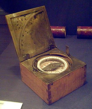
Burt's solar compass or astronomical compass is a surveying instrument that makes use of the Sun's direction instead of magnetism. William Austin Burt invented his solar compass in 1835. The solar compass works on the principle that the direction to the Sun at a specified time can be calculated if the position of the observer on the surface of the Earth is known, to a similar precision. The direction can be described in terms of the angle of the Sun relative to the axis of rotation of the planet.