
Frankfurt is a metropolis and the largest city of the German federal state of Hesse, and its 746,878 (2017) inhabitants make it the fifth-largest city of Germany after Berlin, Hamburg, Munich, and Cologne. On the River Main, it forms a continuous conurbation with the neighbouring city of Offenbach am Main, and its urban area has a population of 2.3 million. The city is at the centre of the larger Rhine-Main Metropolitan Region, which has a population of 5.5 million and is Germany's second-largest metropolitan region after the Rhine-Ruhr Region. Since the enlargement of the European Union in 2013, the geographic centre of the EU is about 40 km (25 mi) to the east of Frankfurt's central business district. Like France and Franconia, the city is named after the Franks. Frankfurt is the largest city in the Rhine Franconian dialect area.
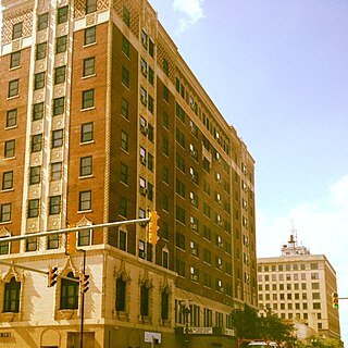
Gary is a city in Lake County, Indiana, United States, 25 miles (40 km) from downtown Chicago, Illinois. Gary is adjacent to the Indiana Dunes National Park and borders southern Lake Michigan. Gary was named after lawyer Elbert Henry Gary, who was the founding chairman of the United States Steel Corporation. The city is known for its large steel mills, and as the birthplace of the Jackson 5 music group.

Kottayam is one of the 14 districts in the state of Kerala, India. Though the district is 65 km south to Kochi, it is located in an area with biggest diameter and population. It is the only district having no border with either the Arabian Sea or the other states.
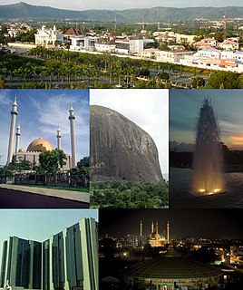
Abuja is the capital city of Nigeria located in the centre of the country within the Federal Capital Territory (FCT). It is a planned city and was built mainly in the 1980s, replacing the country's most populous city of Lagos as the capital on 12 December 1991. Abuja's geography is defined by Aso Rock, a 400-metre (1,300 ft) monolith left by water erosion. The Presidential Complex, National Assembly, Supreme Court and much of the city extend to the south of the rock. Zuma Rock, a 792-metre (2,598 ft) monolith, lies just north of the city on the expressway to Kaduna.

The Loop, one of Chicago's 77 designated community areas, is the central business district in the downtown area of the city. It is home to Chicago's commercial core, City Hall, and the seat of Cook County. Bounded on the north and west by the Chicago River, on the east by Lake Michigan, and on the south by Roosevelt Road, it is the second largest commercial business district in the United States after Midtown Manhattan and contains the headquarters of many locally and globally important businesses as well as many of Chicago's most famous attractions.

A central business district (CBD) is the commercial and business center of a city. In larger cities, it is often synonymous with the city's "financial district". Geographically, it often coincides with the "city centre" or "downtown", but the two concepts are separate: many cities have a central business district located away from its commercial or cultural city centre or downtown.
A federal district is a type of administrative division of a federation, usually under the direct control of a federal government and organized sometimes with a single municipal body. Federal districts often include capital districts, and they exist in various countries worldwide.

Kumamoto Prefecture is a prefecture of Japan located on the island of Kyushu. The capital is the city of Kumamoto.

Quezon City is the most populous city in the Philippines. It was founded by and named after Manuel L. Quezon, the 2nd President of the Philippines, to eventually replace Manila as the national capital. The city was proclaimed as such in 1948. However, since practically all government buildings are still in Manila, many functions of national government remained there. Quezon City held the status as the official capital until 1976 when a presidential decree was issued to designate Manila as the capital and Metro Manila as the seat of government.

New Taipei City is a special municipality and the most populous city in Taiwan. Located in northern Taiwan, the city includes a substantial stretch of the island's northern coastline and surrounds the Taipei Basin, making it the second largest special municipality by area, behind Kaohsiung. New Taipei City is bordered by Keelung to the northeast, Yilan County to the southeast, and Taoyuan to the southwest. It completely surrounds Taipei. Banqiao District is its municipal seat and biggest commercial area. Until 2010, the area that roughly corresponds to the present New Taipei City was known as Taipei County.
A Postal Index Number (PIN), or sometimes redundantly a PIN code, is a code in the post office numbering or postal code system used by India Post, the Indian postal entity. The code is six digits long.
The term district, in the context of China, is used to refer to several unrelated political divisions in both ancient and modern China.

The Kansas City metropolitan area is a 14 county metropolitan area anchored by Kansas City, Missouri, and straddling the border between the U.S. states of Missouri and Kansas. With a population of 2,104,509, it ranks as the second largest metropolitan area centered in Missouri. Alongside Kansas City, the area includes a number of other cities and suburbs, the largest being Overland Park, Kansas; Kansas City, Kansas; Olathe, Kansas; and Independence, Missouri; each over 100,000 in population. The Mid-America Regional Council (MARC) serves as the Council of Governments and the Metropolitan Planning Organization for the area.

The provinces of Peru are the second-level administrative subdivisions of the country. They are divided into districts. There are 196 provinces in Peru, grouped into 25 regions except for the Lima Province which does not belong to any region. This makes an average of seven provinces per region. The region with the fewest provinces is Callao (one) and the region with the most is Ancash (twenty).

The districts of Peru are the third-level country subdivisions of Peru. They are subdivisions of the provinces, which in turn are subdivisions of the larger regions or departments. There are 1,838 districts in total.

New York's 11th congressional district is a congressional district for the United States House of Representatives in New York City. The 11th district includes all of Staten Island and parts of southern Brooklyn, including the neighborhoods of Bay Ridge, Bath Beach, Dyker Heights, south western Gravesend, western Sheepshead Bay, and parts of southern Bensonhurst.

Thanjavur District is one of the 32 districts of the state of Tamil Nadu, in southeastern India. Its headquarters is Thanjavur. The district is located in the delta of the Cauvery River and is mostly agrarian. As of 2011, Thanjavur district had a population of 2,405,890 with a sex-ratio of 1,035 females for every 1,000 males.

Seoul, officially the Seoul Special City, is the capital and largest metropolis of South Korea. With surrounding Incheon metropolis and Gyeonggi province, Seoul forms the heart of the Seoul Capital Area. Seoul is ranked as the fourth largest metropolitan economy in the world and is larger than London and Paris.
Boston, Massachusetts is home to a large number of listings on the National Register of Historic Places. This list encompasses those locations that are located south of the Massachusetts Turnpike. See National Register of Historic Places listings in northern Boston for listings north of the Turnpike. Properties and districts located elsewhere in Suffolk County's other three municipalities are also listed separately.
The Perry County 32 School District is located in Perry County, Missouri and the City of Perryville, Missouri. It serves more than 2,300 students in the School District.


