Other uses
- The Devil's Chair , a 2007 British film
| This disambiguation page lists articles associated with the title Devil's Chair. If an internal link led you here, you may wish to change the link to point directly to the intended article. |
The Devil's Chair are urban legends about funerary or memorial sculpture in cemeteries.
Devil's Chair may also refer to:
| This disambiguation page lists articles associated with the title Devil's Chair. If an internal link led you here, you may wish to change the link to point directly to the intended article. |
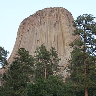
Devils Tower is a butte, possibly laccolithic, composed of igneous rock in the Bear Lodge Ranger District of the Black Hills, near Hulett and Sundance in Crook County, northeastern Wyoming, above the Belle Fourche River. It rises 1,267 feet above the Belle Fourche River, standing 867 feet from summit to base. The summit is 5,112 feet above sea level.
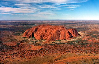
A monolith is a geological feature consisting of a single massive stone or rock, such as some mountains, or a single large piece of rock placed as, or within, a monument or building. Erosion usually exposes the geological formations, which are often made of very hard and solid igneous or metamorphic rock.

Devils Postpile National Monument is a National Monument located near Mammoth Mountain in eastern California. The monument protects Devils Postpile, an unusual rock formation of columnar basalt. It encompasses 798 acres (323 ha) and includes two main tourist attractions: the Devils Postpile formation and Rainbow Falls, a waterfall on the Middle Fork of the San Joaquin River. In addition, the John Muir Trail and Pacific Crest Trail merge into one trail as they pass through the monument. Excluding a small developed area containing the monument headquarters, visitor center and a campground, the National Monument lies within the borders of the Ansel Adams Wilderness.
Quartzite is a hard, non-foliated metamorphic rock which was originally pure quartz sandstone. Sandstone is converted into quartzite through heating and pressure usually related to tectonic compression within orogenic belts. Pure quartzite is usually white to grey, though quartzites often occur in various shades of pink and red due to varying amounts of iron oxide (Fe2O3). Other colors, such as yellow, green, blue and orange, are due to other minerals.

The Stiperstones is a distinctive hill in the county of Shropshire, England. It is a quartzite ridge. The quartzite rock formed some 480 million years ago. During the last Ice Age the summit stood out above the glaciers and was subject to constant freezing and thawing which shattered the quartzite into a mass of jumbled scree surrounding several residual rocky tors. At 536 metres (1,759 ft) above sea level it is the second-highest hill in the county, surpassed only by Brown Clee Hill. Stiperstones' 8-kilometre (5 mi) summit ridge is crowned by several rugged, jagged outcrops of rock silhouetted against the sky.

The Shropshire Hills area, in the English county of Shropshire, is designated as an Area of Outstanding Natural Beauty (AONB). It is located in the south of the county, extending to its border with Wales. Designated in 1958, the area encompasses 802 square kilometres (310 sq mi) of land primarily in south-west Shropshire, taking its name from the upland region of the Shropshire Hills. The A49 road and Welsh Marches Railway Line bisect the area north-south, passing through or near Shrewsbury, Church Stretton, Craven Arms and Ludlow.

Devil's Lake State Park is a state park located in the Baraboo Range in eastern Sauk County, just south of Baraboo, Wisconsin. Devil's Lake State Park is the largest state park in Wisconsin. It is around thirty-five miles northwest of Madison, and is on the western edge of the last ice-sheet deposited during the Wisconsin drift. This 9,217-acre (3,730 ha) state park is known for its 500-foot-high (150 m) quartzite bluffs along the 360-acre (150 ha) Devil's Lake, which was created by a glacier depositing terminal moraines that plugged the north and south ends of the gap in the bluffs during the last ice age approximately 12,000 years ago. The sand at the bottom of Devil's Lake is thought to be deposited by glaciers.

Devil's Millhopper Geological State Park is a Florida State Park located in the north-westernmost part of Gainesville, Florida, off County Road 232, northwest of the University of Florida.
Shropshire's Geology is very diverse and most geological periods of time, and most rock types, can be found within the county. There is also a large amount of mineral wealth in the county, including lead, barytes, limestone, coal and iron, which helped the area develop the industrial revolution west of Clee Hill and, later, in the Ironbridge Gorge area. Quarrying is still active, with limestone for cement manufacture and concrete aggregate, sandstone, greywacke and dolerite for road aggregate, and sand and gravel for aggregate and drainage filters. Groundwater is an equally important economic resource.
Prof William Whitehead Watts FRS HFRSE FGS FMS LLD was a British geologist.

Cueva del Milodón Natural Monument is a Natural Monument located in the Chilean Patagonia, 24 km (15 mi) northwest of Puerto Natales and 270 km (168 mi) north of Punta Arenas.
Đavolja varoš is a peculiar rock formation, located in south Serbia on the Radan Mountain on the territory of the village of Đake in the municipality Kuršumlija.
The Devil's Throat is an underwater cave formation near the island of Cozumel, Mexico, at Punta Sur in the Arrecifes de Cozumel National Park; it starts at approximately 80 feet (24 m) of depth and opens up at approximately 135 ft (41 m) - right at the edge of recreational dive limits.

Devil's Punchbowl, elevation 4,750 ft, is a tilted sandstone formation on the northern slopes of the San Gabriel Mountains, in Los Angeles County, California.

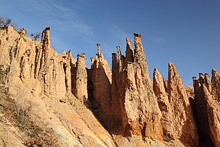
A stone run is a rock landform resulting from the erosion of particular rock varieties caused by freezing-thawing cycles in periglacial conditions during the last Ice Age.

Columnar jointing is a geological structure where sets of intersecting closely spaced fractures, referred to as joints, result in the formation of a regular array of polygonal prisms, or columns. Columnar jointing occurs in many types of igneous rocks and forms as the rock cools and contracts. Columnar jointing can occur in cooling lava flows and ashflow tuffs (ignimbrites), as well as in some shallow intrusions.

The term devil's chair in folklore is frequently attached to a class of funerary or memorial sculpture common in the United States during the nineteenth century and often associated with legend tripping. Nineteenth-century graveyards sometimes included carved chairs for the comfort of visitors. In this function, the object was known as a "mourning chair," and cemeteries have since provided benches for similar purposes, most often movable units of the type used in parks, but also specimens in the tradition of the carved chairs.

Neuquén Basin is a sedimentary basin covering most of Neuquén Province in Argentina. The basin originated in the Jurassic and developed through alternating continental and marine conditions well into the Tertiary. The basin bounds to the west with the Andean Volcanic Belt, to the southeast with the North Patagonian Massif and to the northeast with the San Rafael Block and to the east with the Sierra Pintada System. The basin covers an area of approximately 120,000 square kilometres (46,000 sq mi). One age of the SALMA classification, the Colloncuran, is defined in the basin, based on the Collón Curá Formation, named after the Collón Curá River, a tributary of the Limay River.
The Mercia Mudstone Group is an early Triassic lithostratigraphic group which is widespread in Britain, especially in the English Midlands – the name is derived from the ancient kingdom of Mercia which corresponds to that area. It is frequently encountered in older literature as the Keuper Marl or Keuper Marl Series.