Ventnor is a seaside resort town and civil parish established in the Victorian era on the southeast coast of the Isle of Wight, England, eleven miles (18 km) from Newport. It is situated south of St Boniface Down, and built on steep slopes leading down to the sea. The higher part is referred to as Upper Ventnor ; the lower part, where most amenities are located, is known as Ventnor. Ventnor is sometimes taken to include the nearby and older settlements of St Lawrence and Bonchurch, which are covered by its town council. The population is 5,567 according to the 2021 Census

Blackgang Chine is the oldest amusement park in the United Kingdom, having opened in 1843. Named after a now-destroyed chine in the soft Cretaceous cliffs, it is about 6 miles from Ventnor at the southern tip of the Isle of Wight just below St Catherine's Down. Blackgang Chine are owned by the Dabell family. Blackgang Chine is home to many lands of imagination, including Pirate Cove, Restricted Area 5, Fairy Land and Village, and Cowboy Town. Owing to the unstable land on which the park is situated, landslides occur frequently, meaning that attractions have been moved further inland to safer ground on several occasions.

St Lawrence is a village and former civil parish, now in the parish of Ventnor, on the south coast of the Isle of Wight, in southern England. It is located to the west of the town of Ventnor, in the Undercliff, which is subject to landslips. The Undercliff lies between the original high cliff and the sea, formed over thousands of years, since the last Ice Age, from accumulated landslips. Several rocky coves can be accessed from the coastal path, which affords fine views of some prominent Victorian villas, set in a wooded landscape below the great rock wall of the original sea cliff: Woody Bay, Mount Bay and Orchard Bay. The area of the parish was around 329 acres (133 ha) in size. In 1931 the parish had a population of 329. On 1 April 1933 the parish was abolished and merged with Ventnor.
The Undercliff is the name of several areas of landslip on the south coast of England. They include ones on the Isle of Wight; on the Dorset-Devon border near Lyme Regis; on cliffs near Branscombe in East Devon; and at White Nothe, Dorset. All arose from slump of harder strata over softer clay, giving rise to irregular landscapes of peaks, gullies and slipped blocks, that have become densely vegetated due to their isolation and change of land use. The Kent coast at Folkestone and Sandgate also has similar undercliff areas.

St Boniface Down is a chalk down near Ventnor, on the Isle of Wight, England. Its summit, 241 metres (791 ft), is the highest point on the island, with views on a clear day stretching over 70 miles from Beachy Head to the east, Walbury Hill to the north, the Isle of Portland to the west and the French coast of Normandy to the south. It is 1 kilometre (0.6 mi) north of the town. There is reputed to be a wishing well on its southern slope, which requires the wisher to climb up from the south without looking back. In 1545, a French invasion force attempted this against a force of the Isle of Wight Militia commanded by Sir John Fyssher – which allegedly included several women archers – and were routed. In 1940, the radar station was bombed by Ju 87 Stuka dive bombers, which is reconstructed in the film "The Battle of Britain". The top is surmounted by a round barrow.

Bonchurch is a small village in the civil parish of Ventnor, to the east of the town of Ventnor, now largely connected to the latter by suburban development, on the southern part of the Isle of Wight, England. One of the oldest settlements on the Isle of Wight, it is situated on The Undercliff adjacent to the Bonchurch Landslips Site of Special Scientific Interest. The main village is backed by a cliff to the north, with the Upper Bonchurch section on the clifftop halfway up St Boniface Down on the main A3055 road.

Yaverland is a village and former civil parish, now in the parish of Sandown, on the Isle of Wight, England. It is just north of Sandown on Sandown Bay. It has about 200 houses. About 1⁄3 of a mile away from the village is the Yaverland Manor and Church. Holotype fossils have been discovered here of Yaverlandia and a pterosaur, Caulkicephalus. The White Air extreme sports festival was held annually at Yaverland pay and display car park between 1997 and 2008, but moved to Brighton for 2009.
Chale Green is a hamlet on the B3399 road about a mile inland from the village of Chale on the Isle of Wight. Administratively it is part of Chale.

The A3055 is an A-Class Road on the Isle of Wight in Southern England. It forms the Southern portion of the circular around-the-Island A-class loop, the northern section being the A3054. The stretch along the south-west coast of the Island is formed by the Military Road.

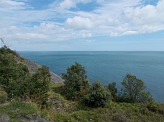
Monks Bay is situated on the southern coast of the Isle of Wight, England just to the east of the village of Bonchurch, it is around 1⁄3 mile (0.54 km) in length. It is popular with visitors and is one of the natural highlights of the town, which has hosted such figures as Charles Dickens. The bay is also a good site for local flora, and it has a row of houses which look out to the English Channel.
Blackgang is a village on the south-western coast of the Isle of Wight, England. It is best known as the location of the Blackgang Chine amusement park which sits to the south of St Catherine's Down.
Puckaster is a hamlet on the Isle of Wight, England. Puckaster is on the southern coast of the Isle of Wight, south of Niton, between St Catherine's Point and Binnel.
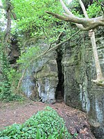
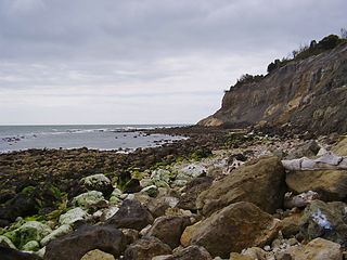
Bonchurch Landslips is a 28.2-hectare (70-acre) site of special scientific interest which is located north-east of Ventnor, Isle of Wight. A wooded coastal landslip zone, the site was notified in 1977 for both its biological and geological features.

The Isle of Wight Coastal Path is a circular long-distance footpath of 70 miles (113 km) around the Isle of Wight, UK. It follows public footpaths and minor lanes, with some sections along roads.

Luccombe Chine is a geological feature and visitor attraction south of the village of Luccombe on the Isle of Wight, England. A wooded coastal ravine, one of a number of such chines on the island created by stream erosion of soft Cretaceous rocks, it leads from the clifftop to Luccombe Bay.
Steel Bay is a bay on the south-east coast of the Isle of Wight, England. It lies to the east of the village of Bonchurch. It faces south-east towards the English Channel and has a one-half-mile (0.80 km) shoreline. It stretches from Bordwood Ledge in the north to Dunnose headland in the south. The bay is remote and has no established access. It is best viewed from Dunnose which can be accessed by scrambling over The Landslip, which is close to the Isle of Wight Coastal Path in the woods to the east of Upper Bonchurch. The bay has a large intertidal reef with outlying rocks, which can be a danger for marine traffic.
The Undercliff, Isle of Wight, England is a tract of semi-rural land, around 5 miles (8.0 km) long by 0.25–0.5 miles (0.40–0.80 km) wide, skirting the southern coast of the island from Niton to Bonchurch. Named after its position below the escarpment that backs this coastal section, its undulating terrain comprises a mix of rough pasture, secondary woodland, parkland, grounds of large isolated houses, and suburban development. Its sheltered south-facing location gives rise to a microclimate considerably warmer than elsewhere on the island. Although inhabited, the Undercliff is an area prone to landslips and subsidence, with accompanying loss of property over time. Settlements along the Undercliff, from west to east, are: lower Niton, Puckaster, St Lawrence, Steephill, the town of Ventnor, and Bonchurch.

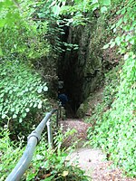
The Chink is a scenic rock cleft between Bonchurch and Luccombe, Isle of Wight, with steps descending from St Boniface Down to the Bonchurch Landslips below.
The footpaths of Gibraltar provide access to key areas of the Upper Rock Nature Reserve, a refuge for hundreds of species of flora and fauna which in some cases are found nowhere else in Europe. The reserve occupies the upper part of the Rock of Gibraltar, a long and narrow mountain that rises to a maximum height of 424 metres (1,391 ft) above sea level, and constitutes around 40 per cent of Gibraltar's total land area. The unusual geology of the Rock of Gibraltar – a limestone peak adjoining a sandstone hinterland – provides a habitat for plants and animals, such as the Gibraltar candytuft and Barbary partridge, which are found nowhere else in mainland Europe. For many years, the Upper Rock was reserved exclusively for military use; it was fenced off for military purposes, but was decommissioned and converted into a nature reserve in 1993.

The Axmouth to Lyme Regis Undercliffs, also often referred to in the singular as the Undercliff, is a 5-mile (8.0 km) long landscape feature, National Nature Reserve and Site of Special Scientific Interest that connects Seaton and Axmouth with Lyme Regis on the south-west coast of England. Like its namesake on the Isle of Wight, this feature arose as a result of landslips, where a slump of harder strata over softer clay gave rise to irregular landscapes of peaks, gullies and slipped blocks. Because of the resulting difficulty of access and change of land use, the undercliff has become densely vegetated, and has become a rare and unusual habitat for plants and birds.