
Iguazú Falls or Iguaçu Falls are waterfalls of the Iguazu River on the border of the Argentine province of Misiones and the Brazilian state of Paraná. Together, they make up the largest waterfall system in the world. The falls divide the river into the upper and lower Iguazu. The Iguazu River rises near the heart of the city of Curitiba. For most of its course, the river flows through Brazil; however, most of the falls are on the Argentine side. Below its confluence with the San Antonio River, the Iguazu River forms the border between Argentina and Brazil.

Hatra was an ancient city in Upper Mesopotamia located in present-day eastern Nineveh Governorate in northern Iraq. The ruins of the city lie 290 km (180 mi) northwest of Baghdad and 110 km (68 mi) southwest of Mosul. It is considered the richest archaeological site from the Parthian Empire known to date.

The Niokolo-Koba National Park is a World Heritage Site and natural protected area in southeastern Senegal, near the Guinea border. It is served by Niokolo-Koba Airport, an unpaved airstrip.
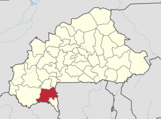
Poni is one of the 45 provinces of Burkina Faso, located in its Sud-Ouest Region.

Castle Island is part of the chain which makes up Bermuda. It is located in St. George's Parish, in the northeast of the territory.
Galathea National Park is a national park located in the Union Territory of Andaman and Nicobar Islands, India. It is located on the island of Great Nicobar in the Nicobar Islands, which lie in the eastern Indian Ocean.
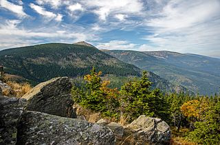
Giant Mountains National Park is a National Park in the Giant Mountains in the Sudetes in southwestern Poland, along the border with the Czech Republic.
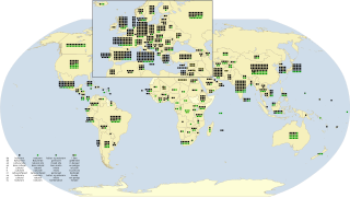
As of July 2024, there are a total of 1,223 World Heritage Sites located across 168 countries, of which 952 are cultural, 231 are natural, and 40 are mixed properties. The countries have been divided by the World Heritage Committee into five geographical regions: Africa, the Arab States, Asia and the Pacific, Europe and North America, and Latin America and the Caribbean. With 60 selected areas, Italy is the country with the most sites, followed by China with 59, and Germany with 54.

The Sibelius Monument by Eila Hiltunen is dedicated to the Finnish composer Jean Sibelius (1865–1957). The monument is located in Sibelius Park in the Töölö district of Helsinki, Finland.

Johnston's genet is a genet species native to the Upper Guinean forests. As it is threatened by deforestation and conversion of rainforest to agriculturally and industrially used land, it is listed as Near Threatened on the IUCN Red List.

Waterton Lake (Paahtómahksikimi) is a mountain lake in southern Alberta, Canada, and northern Montana, United States. The lake is composed of two bodies of water, connected by a shallow channel known locally as the Bosporus. The two parts are referred to as Middle Waterton Lake, and Upper Waterton Lake, the latter of which is divided by the Canada–United States border with Canada containing about two thirds of the lake while the southern third falls in the United States. The Boundary Commission Trail ends at the lake as the last border marker was placed there on 8 August 1874. The United States Geological Survey gives the geocoordinates of 49°03′00″N113°54′03″W for Upper Waterton Lake. Lower Waterton Lake is north of Middle Waterton Lake and is separated by a channel known as the Dardanelles.

The Ciénaga Grande de Santa Marta is the largest of the swampy marshes located in Colombia between the Magdalena River and the Sierra Nevada de Santa Marta. It has an area of 4,280 square kilometres (1,650 sq mi) and belongs to the outer delta system of the Madgalena River. It is separated from the Caribbean Sea by a narrow, sandy artificial spit built in the 1950s, on which is situated coastal route 90 from Barranquilla to Santa Marta. The marsh's large lagoon is connected to the Caribbean Sea via a narrow strait located between the town of Pueblo Viejo and the city of Ciénaga.
Kédougou department is one of the 46 departments of Senegal, located in the Kédougou region, formerly part of the Tambacounda region.

Villamaría is a town and municipality in the Colombian Department of Caldas. Located in the Colombian coffee growing axis, it was made part of the "Coffee Cultural Landscape" UNESCO World Heritage Site in 2011.
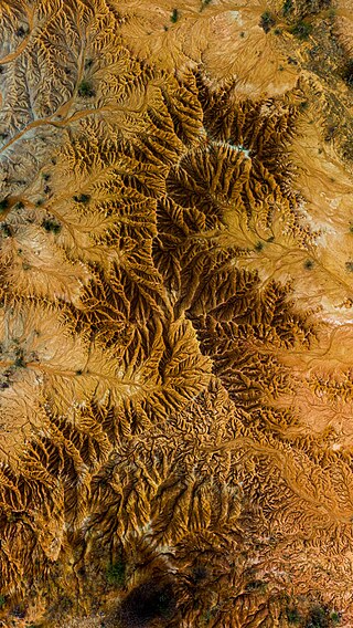
The Tatacoa Desert is the second largest arid zone in Colombia after the Guajira Peninsula. It occupies more than 330 square kilometers. This region is located north of Huila Department, 38 km from the city of Neiva and 15 km (9 mi) from Natagaima in Tolima. It is renowned as a rich deposit of fossils and a tourist destination. The Tatacoa Desert has two distinctive colors: ochre in the area of Cuzco and gray in the Los Hoyos area.

Niagassola is a town and sub-prefecture in the Siguiri Prefecture in the Kankan Region of north-eastern Guinea. It is located near the border with Mali. It has no electricity and three water pumps.
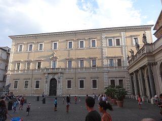
The Palazzo San Callisto is a Baroque palace in the Trastevere neighborhood of Rome and one of the extraterritorial Properties of the Holy See. The original Palazzo is located in the Piazza di Santa Maria in Trastevere, the later extensions have their entrance in Piazza di San Callisto. The entire complex is one of the areas of the Holy See regulated by the 1929 Lateran Treaty signed with the Kingdom of Italy. As such it has extraterritorial status.

Mount Arrowsmith Biosphere Region (MABR) is a UNESCO Biosphere Reserve located on the east coast of Vancouver Island in British Columbia, Canada. It was designated in 2000 by UNESCO to protect a large second-growth coast Douglas fir ecosystem in the watersheds of the Little Qualicum and Englishman Rivers from being developed.
Nahá–Metzabok Biosphere Reserve is a biosphere reserve in southeastern Mexico. It is located in the state of Chiapas, on the northeastern flank of the Chiapas Highlands. The reserve protects montane rain forests, pine and oak forests, and natural lakes.
